Home > Historic Landscapes > Black Mountain and Mynydd Myddfai > |

254 CILMAENLLWYD 
GRID REFERENCE: SN 668200
AREA IN HECTARES: 258.30
Historic Background
A small character area within the foothills of the Black Mountain, once
forming part of Maenor Llys which occupied the eastern part of Iscennen
commote. Iscennen, unlike the rest of Cantref Bychan within which it lay,
remained nominally independent of Anglo-Norman rule until 1284 when it
was acquired by John Giffard, and in 1340 it became a member of the Duchy
of Lancaster (Rees 1953, xv-xvi). Part of Area 254 may, like neighbouring
Area 197, have formed part of the estate of the Maerdref of Carreg Cennen
(see Area 198); a settlement is marked (as 'Penthill' ) at Penhill Farm
on Rees' map of 14th century south Wales (Rees 1932). However, the bulk
of the area, around the large, central farm of Cilmaenllwyd, appears to
have belonged to the Premonstratensians of Talley Abbey (Rees 1932). The
holding had fallen to the Lloyds, a recusant family, by the 17th century,
when horse races were held nearby (Jones 1987, 34); it was later let to
tenants. In the western part of the area are a group of narrow fields
which may represent former open fields; the reminder of the enclosures,
however, are large and fairly regular, and may be Post-Medieval in origin.
There has been little recent development.
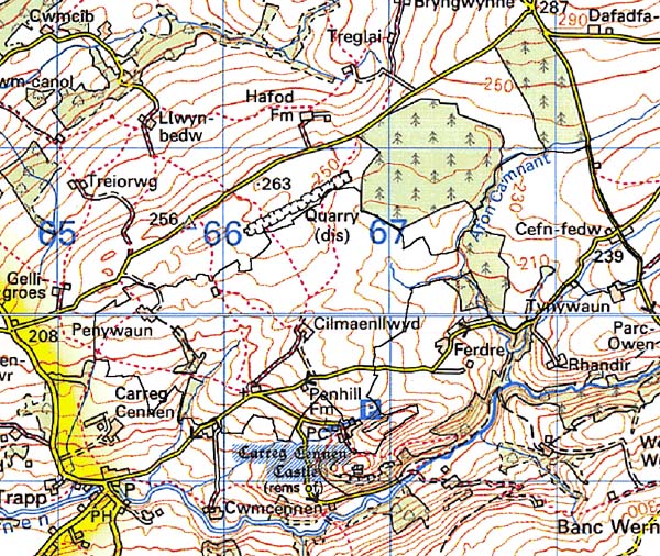
Base map reproduced from the OS map with
the permission of Ordnance Survey on behalf of The Controller of Her Majesty's
Stationery Office, © Crown Copyright 2001.
All rights reserved. Unauthorised reproduction infringes
Crown Copyright and may lead to prosecution or civil proceedings. Licence
Number: GD272221
Description and essential historic
landscape components
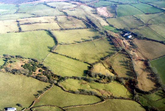
This character area lies on fairly gentle south- and southwest-facing
slopes between 180 m and 240 m. It comprises dispersed farms and other
dwellings situated in medium-sized irregular and regular fields. The fields
are defined by earth, and stone and earth banks, topped with hedges. Apart
from alongside roads and tracks hedges are not generally in good condition,
and are either derelict or have many gaps. Wire fences provide stock-proof
boundaries. There are very few hedgerow trees, and this, coupled with
just a few small deciduous woods, lends an open appearance to much of
the landscape. Most of the farmland is improved pasture, though there
are isolated pockets of rough grazing and rushy ground. Transport links
are purely local - lanes and tracks. Farmhouses are stone-built, three-storey,
and three-bayed, 19th century and generally in the vernacular tradition.
Smaller stone-built 19th century cottages in the vernacular tradition
are also present. 19th century farm outbuildings are of stone, and generally
of one or two ranges. Most farms have modern agricultural buildings.
Recorded archaeology is limited to the Medieval settlement at Penhill, a mill site and dwellings.
There are no listed buildings.
Cilmaenllwyd is not an easy character area to define as many of the neighbouring areas share similar landscape components. Thus there tends to be a zone of change between this area and its neighbours.