Home > Historic Landscapes > Black Mountain and Mynydd Myddfai > |

235 MAES-GWASTAD 
GRID REFERENCE: SN 727290
AREA IN HECTARES: 500.30
Historic Background
An area southeast of the River Tywi which once formed part of Perfedd
commote of Cantref Bychan, which was invaded by the Anglo-Normans advancing
from the east under Richard Fitz Pons who established a caput at Llandovery
in 1110-16 (Rees n.d.). It was acquired soon after by the Clifford lords
of Brecon as the Lordship of Llandovery. However, there were many episodes
of Welsh rule and the area retained native tenurial customs until the
end of the Medieval period when it was incorporated into modern Carmarthenshire.
Most of this character area formed part of the patria of Llangadog which
was acquired by the Bishops of St Davids in the later 13th century (Rees
1932). Medieval settlement and formalised land-division is suggested from
place-name evidence in other areas that lay within the patria (eg. Area
207), and similarly the names within Area 235 suggest the presence of
former open field strips, possibly belonging to the emerging borough of
Llangadog (Area 206), and a quillet of such enclosed strips appears to
lie at the north end of the area. The motte-and-bailey castle at Castell
Meurig 1.5 km southeast of Llangadog appears to belong to the early, initial
phase of Anglo-Norman campaign. It was captured 'by catapults and slings'
by Prince Maelgwn ap Rhys in 1203 (Jones 1952, 82) after which it may
have become disused; at any rate, it appears not to have influenced any
subsequent settlement. The area's Post-Medieval history, during which
the Lordship of Llandovery was held by the Vaughans of Golden Grove and
later the Earls of Cawdor (James n.d., 87), was dominated by the gentry
house at Glansevin which had been the home of the Lloyd family since the
16th century and was assessed at 8 hearths in 1670 (Jones 1987, 78). The
dwelling itself, which is now a hotel, lies in Area 228 but the home farm
and mill lie in this character area. Glansevin-issa, just to the north,
is mentioned in 1634 when it was mortgaged for £100 to become part of
the Dirleton estate in Area 201 (ibid.). The A4069 between Llangadog and
Llandovery, which forms the northwestern edge of the character area, follows
the line of a turnpike begun in 1779 (Lewis 1971, 43). Recent development,
however, has been slight; a very small nucleation has developed around
the 19th century non-conformist chapel at Sardis, off of the main route,
whilst the northwest corner of the area, where it runs into Llangadog
(Area 206), has seen some 20th century development.
Base map reproduced from the OS map with
the permission of Ordnance Survey on behalf of The Controller of Her Majesty's
Stationery Office, © Crown Copyright 2001.
All rights reserved. Unauthorised reproduction infringes
Crown Copyright and may lead to prosecution or civil proceedings. Licence
Number: GD272221
Description and essential historic
landscape components
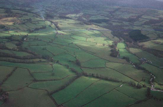
Maes-gwastad character area occupies the wide valley floor of the Afon
Brân to the east of Llangadog. It is relatively flat and lies between
c. 60 m and 80 m above sea level. It is essentially a landscape of improved
pasture fields and dispersed farms. Fields are medium- to large-sized
and vary from the fairly regular to the irregular. Some are strip-shaped,
indicating enclosure from an open field system. Boundaries are universally
of earth banks topped with hedges. Hedges are very well maintained. The
area has an open appearance owing to the fact that there are few hedgerow
trees and very little woodland. The A4069 is a former turnpike; other
routes are local lanes and tracks. The settlement pattern is one of dispersed
farms. Farmhouses are stone-built, generally 19th century, two-storey
and three-bays, with examples in the vernacular tradition as well as the
more polite 'Georgian' style. 19th century outbuildings associated with
the farms are substantial, as are modern agricultural buildings.
The recorded archaeology is dominated by the scheduled earthworks of the large, well preserved motte-and-bailey castle at Castell Meurig. There are also Iron Age or Roman finds, the enclosed Medieval open fields, and two unknown earthworks.
There are some distinctive buildings, but none are listed, including Glansevin Bridge, home farm and mill, Glansevin-issa, a Sunday school, and further mills and bridges.
This is not an easy area to define, as the neighbouring character areas share similar traits. However, the generally more wooded character and smaller field size of bordering areas provide sufficient differences to draw a reasonably hard-edged boundary to this area.