Home > Historic Landscapes > Black Mountain and Mynydd Myddfai > |

234 CEFNTELYCH 
GRID REFERENCE: SN 799322
AREA IN HECTARES: 257.90
Historic Background
A small area on the western fringes of the Brecon Beacons, formerly within
Maenor Myddfai, Cwmwd Perfedd, of the former Cantref Bychan, which was
invaded by the Anglo-Normans under Richard Fitz Pons who established a
caput at Llandovery in 1110-16 (Rees n.d.). It was acquired soon after
by the Clifford lords of Brecon as the Lordship of Llandovery but reverted
to Welsh rule until 1282 when it was acquired by John Giffard (James n.d.,
87). It retained native tenurial customs until the end of the Medieval
period when it was incorporated within modern Carmarthenshire. The lordship
was later held by the Audleys, and in the Post-Medieval period by the
Vaughans of Golden Grove and the Earls of Cawdor (James n.d., 87). Cefntelych
ridge is now enclosed with large, fairly regular fields which were established
by 1840 (Myddfai tithe map). They may be later Post-Medieval rather than
earlier, and the ridge may have been unenclosed for much of the historic
period. It is crossed by the Roman road following the upland route from
Llandovery (Alabum) to Brecon (Cicutio), as a result of which the region
(including neighbouring Area 240), exhibits a number of Roman military
sites (James 1982, 9), such as a marching camp and a practice camp at
Allt-y-hafod-fawr. There has been no subsequent development within the
character area apart from one small informal holding.
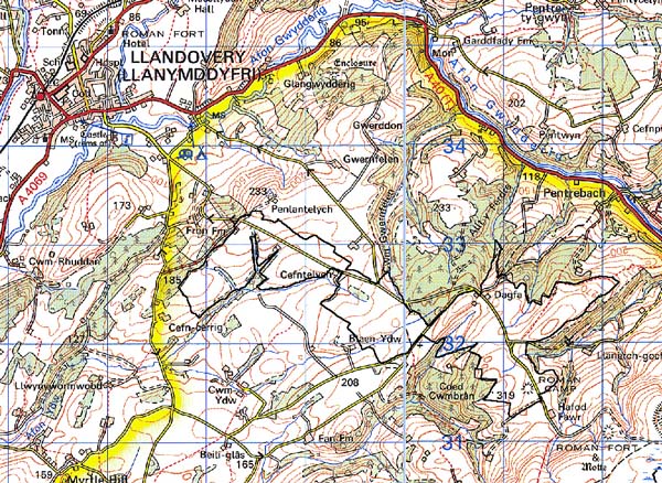
Base map reproduced from the OS map with
the permission of Ordnance Survey on behalf of The Controller of Her Majesty's
Stationery Office, © Crown Copyright 2001.
All rights reserved. Unauthorised reproduction infringes
Crown Copyright and may lead to prosecution or civil proceedings. Licence
Number: GD272221
Description and essential historic
landscape components
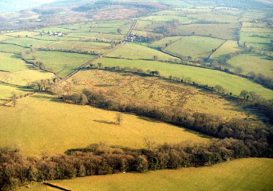
This relatively small character area comprises a northwest to southeast
ridge between 180 m and 270 m. Apart from a single small farm with a 19th
century farmhouse in the vernacular tradition and a small range of outbuildings,
there are no settlements in the area. A straight lane - the course of
a Roman road - runs along the ridge. Essentially this is a landscape of
medium- to large-sized fairly regular fields which are divided by earth
banks topped with hedges. Apart from alongside roads and tracks, hedges
are in poor condition and are either derelict or overgrown. There are
few distinctive hedgerow trees, and this factor combined with the lack
of woodland and the derelict hedges lends an open feel to the landscape.
Land-use is almost entirely improved pasture.
Archaeology is dominated by the Roman road, practice camp and marching camp which survive as earthworks and provide time-depth to the landscape. There is also a possible inscribed stone
There are few buildings within the area and none are distinctive.
The character area to the west, shares many historic components with this area - here there is a zone of change rather than a hard-edged border. Elsewhere to the south and west the heavily wooded aspect and smaller fields of neighbouring area provide a reasonably clear boundary. A conifer plantation lies to the east.