Home > Historic Landscapes > Black Mountain and Mynydd Myddfai > |

211 BLAENSAWDDE 
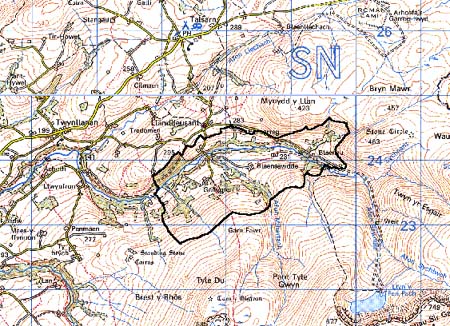
GRID REFERENCE: SN 783236
AREA IN HECTARES: 311.40
Historic Background
A small area occupying the northern fringe of the Black Mountain.
It once lay within Perfedd commote - specifically Maenor Llanddeusant
- of Cantref Bychan, which was invaded by the Anglo-Normans advancing
from the east under Richard Fitz Pons who established a caput at Llandovery
in 1110-16 (Rees n.d.). It was acquired soon after by the Clifford lords
of Brecon as the Lordship of Llandovery, but there were many episodes
of Welsh rule and the area retained native tenurial customs until the
end of the Medieval period when it was incorporated into modern Carmarthenshire.
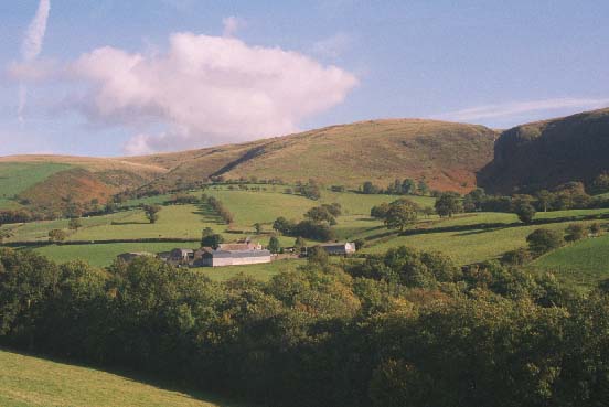
The character area lies on the edge of unenclosed moorland and comprises
several different 'landscapes' upon a north-facing slope, including a
number of fertile pockets of land. A number of different regimes would
be feasible; Blaensawdde Farm is a good example of a holding spread down
the slope and containing just such a landscape variety, whose origins
are at least early Post-Medieval. It lies centrally within the area and
is 'an excellent example of the traditional Welsh gentry house', linked
in popular culture with the legend of the fairy maiden of Llyn-y-fan Fach
(Jones 1987, 11). It became the centre of an estate which, at its height
in the early 19th century, comprised 15 farms in Llanddeusant parish including
Gorsddu, and much of Area 211(Beckley 1991, 39-40). An estate map from
1744 shows a pattern of enclosure identical to that of today (ibid.),
suggesting that the landscape had been established when the present farmsteads
were built in the 17th century. Two sheepfolds on the periphery of the
area, probably from the 18th century, demonstrate the continuing importance
of pastoralism within the economy.
Base map reproduced from the OS map with
the permission of Ordnance Survey on behalf of The Controller of Her Majesty's
Stationery Office, © Crown Copyright 2001.
All rights reserved. Unauthorised reproduction infringes
Crown Copyright and may lead to prosecution or civil proceedings. Licence
Number: GD272221
Description and essential historic
landscape components
This relatively small but nevertheless distinct character area consists
of enclosed land in the upper Sawdde valley; bordered on three sides by
open moorland of the Black Mountain. The valley floor lies at approximately
22 0m; the upper limit of enclosure is above 300m. The whole of the character
area is enclosed into small- and medium-sized irregular fields. The boundary
between enclosed land of this area and unenclosed moorland is very sharp
- there does not appear to be any abandoned fields or dwellings on the
moorland fringe as is common in other parts of upland Wales. Banks with
hedges provide the main boundary type. Hedges at higher altitudes are
in poor condition and many have gone or are derelict. At lower levels
they tend either to be overgrown or very well maintained. Wire fences
supplement the hedges. Many hedges have distinctive hedgerow trees. These
trees together with stands of ancient deciduous woods on the lower valley
sides and pockets of scrubby blackthorn and hawthorn on the fringes of
the moorland, lend a wooded appearance to the landscape. Agricultural
land-use is predominantly improved pasture, but there are considerable
tracts of rough, rushy ground on north-facing slopes towards the western
end of the area. The settlement pattern is of dispersed farms. Farmsteads
on the south side of the valley are located high up on gentle north-facing
slopes and consist of large, two-storey, stone-built farmhouses of 17th-
to 19th-century date, constructed with a degree of architectural consideration.
Stone-built buildings on these farms, including Blaensawdde and Gorsddu,
are similarly substantial, and situated in a semi-arrangement with the
house. These farms also possess a large range of modern agricultural buildings.
Farmsteads on the north side of the river, including Cwmsawdde, tend to
be located lower down in the valley and are generally more modest, consisting
of 19th century two-storey houses in the vernacular tradition, with stone-built
outbuildings compacted into a single range.
Recorded archaeology is limited to dwellings and cottages.
There is a high percentage of distinctive buildings for such a small area, some of them with early components. Blaensawdde is a 17th century house with a complex history of developmental from a conventional two-unit range into a building with a cruciform plan; some of the fine interior still remains, including a post-and-panel partition, while the farm buildings include a barn and byre range dated 1834. The origins of Gorsddu are early 17th-century, although it was altered in the early 19th century, and it comprises a house and outbuildings in line under a single roof. Cwmsawdde is an early-19th century vernacular farmhouse with a barn, cowhouse and stable. In addition there are two sheepfolds. To the south, east and north, the open moorland of the Black Mountain provides a sharp border to this area. To the west, along the Sawdde valley, a hard-edged border does not exist and this area fades into its neighbour.