|

221 CRAIG Y BWCH 
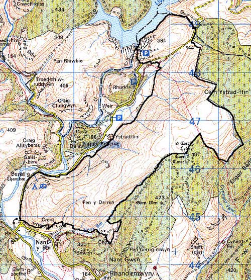
GRID REFERENCE: SN 791468
AREA IN HECTARES: 731.60
Historic Background
An area in the foothills of the Cambrian Mountains east of the headwaters
of the River Tywi, formerly lying within Cwmwd Hirfryn of Cantref Bychan,
which was invaded by the Anglo-Normans under Richard Fitz Pons who established
a caput at Llandovery in 1110-16 (Rees n.d.). It was acquired soon after
by the Clifford lords of Brecon as the Lordship of Llandovery. However,
it retained native tenurial customs until the end of the Medieval period.
Area 221 lay within the Manor of Nant-y-bai, which had been granted as
a grange to the Cistercians of Strata Florida, probably by Gruffydd ap
Rhys in c.1200. It was an upland grange, probably operated by tenant farmers
primarily concerned with the mountain pasturing of animals (Sambrook and
Page 1995, 18). The manor of Nant-y-bai remained together after the Dissolution
as the Ystrad-ffin estate (Carmarthenshire Record Office, Lort Muniments
17/678). It appears to have been unenclosed during the historic period,
as it is today, and is depicted as open pasture on the earliest historic
maps. There is physical evidence for former use, however; Bronze Age round
barrows provide time-depth and evidence for former human occupation of
this upland area. There are also a number of former longhuts, characteristic
of upland settlement in southwest Wales during the transitional, early
Post-Medieval - modern period, and former cottages from the 18th- and
early 19th-century (Sambrook and Ramsey, 1999). The area is also characterised
by evidence for former lead mining which may have begun under the Cistercians
(Williams 1990, 58). It was definitely being undertaken in this area by
the late 13th-century, the crown taking the 'eleventh foot' of the ore
in taxation (Rees 1968); mining ceased from the mid 19th-century. The
presence of coal is noted in the place-name 'Nant-y-glo' and quarries
are also present. The area has no recent settlement, but the weir and
overflow for Llyn Brianne reservoir, constructed at the northern edge
of the area during the 1960s, has had a profound effect on the landscape.
Base map reproduced from the OS map with the permission
of Ordnance Survey on behalf of The Controller of Her Majesty's Stationery
Office, © Crown Copyright 2001.
All rights reserved. Unauthorised reproduction infringes Crown Copyright
and may lead to prosecution or civil proceedings. Licence Number: GD272221
Description and essential historic landscape components
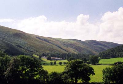
Craig y Bwch character area lies on the eastern side of the upper
Tywi valley. From the valley floor at approximately 200 m, the valley
sides rise steeply to over 400 m, and then continue to rise onto an undulating
plateau at over 470 m. The area is unenclosed. Valley sides are craggy,
and the plateau is wet and boggy. Bracken lies on the steep slopes. The
plateau is dominated by rough grazing interspersed with pockets of improved
land. Quarries and mines, with tramways leading diagonally down the valley
side, provide one of the few distinctive man-made features of the landscape.
Recorded archaeology provides time-depth represented by Bronze Age round barrows, while there are longhuts, former cottages and dwellings, and lead mine features from the Post-Medieval period.
The only standing structure is the late 20th century Llyn Brianne weir which deserves note.
Craig y Bwch is a distinctive character area. It is bounded to the west and south by enclosed farmland of the floor of the Tywi valley, to the east and northeast by an extensive upland forestry plantation, and to the north by Llyn Brianne reservoir.