|

204 FELINDRE 
GRID REFERENCE: SN 699275
AREA IN HECTARES: 69.86
Historic Background
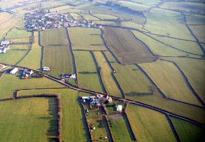
A small area to the south-east of the River Tywi lying immediately to the west of Carreg-Sawdde Common (Area 205). It was once part of Perfedd commote of Cantref Bychan, which was, with the exception of Iscennen, invaded by the Anglo-Normans advancing from the east under Richard Fitz Pons who established a caput at Llandovery in 1110-16 (Rees n.d.). It was acquired soon after by the Clifford lords of Brecon as the Lordship of Llandovery. However, Cantref Bychan was subject to episodes of Welsh rule until 1276 when it was granted - to be reunited with Iscennen - to the Gloucestershire knight John Giffard (Rees 1953, xv) and retained native tenurial customs until the end of the Medieval period. Carreg-Sawdde represents an area of remnant common within what may formerly have been an extensive tract of unenclosed grazing. However, by the 14th century Felindre was a demesne estate of the Lordship of Llandovery (Rees 1924, 100), presumably named from a pre-existing corn mill, and within which agriculture was practised; 15 bond men - the only bond tenants of the lordship - farmed 18 acres in 1317 (ibid.). Like the maerdref at Ferdre, Carreg Cennen (Area 198), Felindre had its own court and was administered by a reeve. In 1383 it was granted an annual fair by the successor to the Gifford Lords of Llandovery, Nicholas d'Audley (ibid.), which was still being held in 1601 (Sambrook and Page 1995, 22). However, the system of small, axial, regular rectangular fields which form a distinctive block to the west of the village may result from 18th century squatting on the edge of the common, rather than a fossilisation of Medieval strip fields; moreover the fields occupy a total of 172.60 acres. The system was in place - and Felindre was a nucleated settlement - by 1839 when the tithe map of Llangadog parish shows a landscape identical to the present.
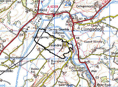
Base map reproduced from the OS map with the permission
of Ordnance Survey on behalf of The Controller of Her Majesty's Stationery
Office, © Crown Copyright 2001.
All rights reserved. Unauthorised reproduction infringes Crown Copyright
and may lead to prosecution or civil proceedings. Licence Number: GD272221
Description and essential historic landscape components
Felindre is a small character area that lies on a terrace on the south side of the Tywi and west of the Sawdde at approximately 45 m OD, a few metres above the flood plains of the rivers. It consists of a small nucleation of dwellings at Felindre, and several dispersed small-holdings/farms. Felindre is a mixture of 19th- and 20th-century dwellings. Several stone-built small-holdings, in the vernacular tradition, are dispersed outside the nucleation and most have a small range of outbuildings associated with them. A distinctive but small enclosed strip field system is associated with the settlement. Earth banks with hedges comprise the boundaries to these fields. Hedges are generally well maintained and some have distinctive trees, but a few have gaps opening up in them. Wire fences support all hedges. There is no woodland in this area, and almost all ground is under improved pasture.
Recorded archaeology relates to the settlement and includes the present Post-Medieval watermill and the village with a pigsty and a smithy.
There are no distinctive buildings. Felindre itself has 19th century stone-built dwellings, in the vernacular style, intermixed with 20th century dwellings in a variety of styles and materials. The farmhouses of the several small-holdings dispersed outside the nucleation are stone-built, of 19th century date, in the vernacular tradition and generally of two storeys with slate roofs.
The strip field system and nucleated settlement make this a very distinctive character area. It stands in contrast to unenclosed common to the east, the Tywi flood plain to the north, and areas of dispersed farms and irregular fields to the south and west.