|

196 YSTRAD TYWI: LLANDEILO - LLANGADOG 
GRID REFERENCE: SN 662250
AREA IN HECTARES: 769.40
Historic Background
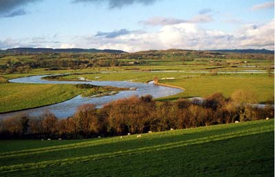
A long, narrow area stretching from Llandeilo in the west to Llangadog in the east, which lies in the fertile alluvial floodplain of the River Tywi and includes a short stretch of one of its tributaries, the Afon Dulais. The valley was the major historic route corridor into West Wales and the Roman road from Carmarthen to Llandovery, which forms the north-western edge of this character area, was constructed along the interface between the alluvium and the solid geology of the north side of the Tywi, and was more-or-less followed by a later turnpike and the present A40(T) - see also Area 182. The River Tywi in this area is particularly active and subject to constant and radical course change across its valley floor, cutting and re-cutting its way through the alluvium and leaving behind a complex of meanders and ox-bow lakes (Ludlow 1999, 21). Evidence from maps, documents and aerial photography suggests that the course has changed greatly even since the Post-Medieval period. The Roman road was therefore directed along the higher ground just off of the valley floor, and settlement on the floodplain itself has always been minimal; there are now no farms or dwellings within the area. However, the landscape had been enclosed, in the present pattern of regular fields, by the time the tithe surveys were conducted in the second quarter of the 19th century; the process was probably undertaken during the 18th century. Earlier and prehistoric environments and settlement patterns of the Tywi Valley are among 'the least known' (Cadw/ICOMOS 1998, 28), but the interface between the floodplain and higher ground would have been an important area of activity for early human communities in the region, providing easy access to the resources of the river and its associated wetlands whilst providing a dry occupation site. Ad hoc archaeological work has suggested that there are glacially deposited raised areas of ground on the valley floor (ibid.), and peat deposits have been noted between the alluvium and the underlying geology elsewhere within the Tywi Valley, for example at Abergwili and Pensarn, near Carmarthen (Page 1994, 4,9). Here they were thought either to represent 'islands' in the floodplain, or a drying of the floodplain, while Bronze Age stray find sites, and possible round barrows, testify to prehistoric activity within the area. During the Medieval period the river formed one of the major boundaries of Carmarthenshire, separating Cantref Mawr on the north bank from Cantref Bychan on the south bank (Rees, 1932). As such, the landscape area has experienced a chequered history of tenure and was troubled by warfare until the end of the 13th century. Cantref Mawr, unlike Cantref Bychan which was subject to 12th century conquest and reconquest, remained an independent Welsh lordship until 1284 (Rees 1953, xv). There never appears to have been a bridge across the Tywi between Llandeilo and Llangadog, but a possible ford, and perhaps a Medieval battle site, are suggested by the name 'Rhyd-y-Saeson' near Llangadog. A turnpike, established in 1763-71 (Lewis, 1971, 43) more-or-less followed the line of the Roman road although the course through Cwm-Ifor was straightened under Thomas Telford in the 1820s (Carmarthenshire Record Office, Cawdor Maps 172) with the subsequent development of the village. The entire area is crossed by the former LNWR main West Wales railway line which was opened, as the 'Vale of Towy Line', by the Llanelly Railway and Dock Company in 1858 (Gabb, 1977, 76).
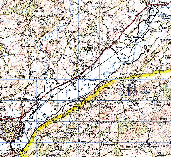
Base map reproduced from the OS map with the permission
of Ordnance Survey on behalf of The Controller of Her Majesty's Stationery
Office, © Crown Copyright 2001.
All rights reserved. Unauthorised reproduction infringes Crown Copyright
and may lead to prosecution or civil proceedings. Licence Number: GD272221
Description and essential historic landscape components
The flood plain of the River Tywi between Llandeilo and Llangadog rises a little over 20 m over 9 km. It averages 1.5 km in width. This stretch of the Tywi, unlike the lower section between Carmarthen and Llandeilo (Area 182), has an active erosion and deposition cycle over long stretches of its course, with shifting meanders. In these locations the marshy, scrubby and rough ground is present. Elsewhere the floodplain has been divided into a rather loose pattern of medium- to large-sized irregular and regular fields of improved pasture by hedges without banks and earth banks topped with hedges. The former are planted on the valley floor presumably to facilitate flood-water drainage. The condition of these enclosures varies considerably. In certain locations, particularly close to the river, hedges are virtually redundant and wire fences run along the earth banks. In other areas hedges are well maintained and in good condition. Many hedges possess distinctive hedgerow trees. There is no woodland and no settlement in this character area. The wooded nature of the valley, however, was commented upon by early writers including Leland in the 1530s (Smith 1906), who appears to be describing the floodplain. The railway line which runs along the floodplain on a low embankment is a distinctive landscape element.
Recorded archaeology is limited but includes Bronze Age finds and possible round barrow sites near Llandeilo and Cwm-Ifor. Other later features include road and rail bridges, stations and other railway furniture. The importance of buried deposits within the floodplain cannot, however, be overstressed.
There are no distinctive buildings.
The loose field systems and lack of settlement and woodland on the flood plain of the Tywi provides a distinct character area and stands in contrast to the surrounding area of occupied land (Areas 191, 201, 202, 204, 205 and 225).