|

186 ABERGWILI 
GRID REFERENCE: SN 438209
AREA IN HECTARES: 12.24
Historic Background
The built-up area of the former borough of Abergwili. It is clear that Abergwili has pre-Conquest origins. It developed along the Roman road from Carmarthen to Llandovery, whose course was roughly followed by the modern A40(T) until the village was bypassed in 1999. It was a possession of the Bishops of St Davids, maybe as the result of a pre-Conquest grant, while the church, which is also dedicated to St David, is probably a pre-Conquest foundation (Ludlow 1998). In addition, Abergwili is named in an early 11th-century source as the site of a battle (Jones 1952, 12). It was certainly in episcopal hands by 1220 when Rhys Grug was bound to restore 'all the lands at Abergwili' to the Bishop (James 1980, 19), but part of the church was granted to Carmarthen Priory in 1267. Organised settlement dates to 1283-7 when the college at Llangadog was moved to Abergwili under Bishop Thomas Bek (ibid.), constituted for 22 prebendaries, 4 priests, 4 choristers and 2 clerks (Lewis, 1833). In 1334 Bishop Henry Gower added a precentor, chancellor and treasurer and the college had an annual revenue of £42 in 1536 (Ludlow 1998). Borough status was conferred on the settlement which remained small. In 1326 there were only 25 burgages (Soulsby 1983, 69) and it is unlikely that the settlement extended beyond its present confines. However, there was a market every Friday and at least one annual fair (ibid.). The college was again moved under Bishop Thomas Barlow in 1541, to Brecon, and the buildings, which were arranged around a cloister some 150 m east of the church, were converted into a palace for the Bishop. This survived various alterations and additions until 1903 when it was consumed by fire, and rebuilt (Soulsby 1983, 69 n.). The pre-1999 A40(T) route was turnpiked in 1763-71 (Lewis, 1971, 41) and the area is bounded to the north by the former LNWR main West Wales railway line which was opened, as the 'Vale of Towy Line', by the Llanelly Railway and Dock Company in 1858 (Gabb, 1977, 76). Twentieth century development includes the new Bishops Palace, constructed on the site of the stables in 1972 when the old palace was acquired by Carmarthenshire County Council to house its County Museum, a primary school and council housing, while the construction of the Carmarthen Eastern Bypass (A40) in 1999 along the northern edge of the area will reduce traffic through Abergwili and may have an economic impact.
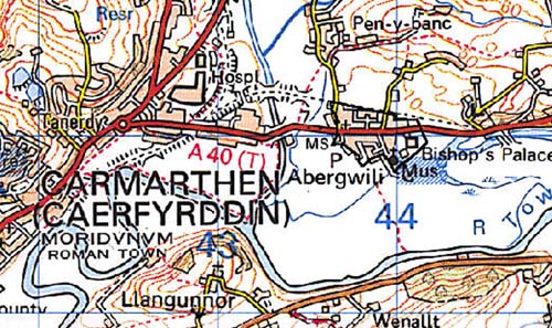
Base map reproduced from the OS map with the permission
of Ordnance Survey on behalf of The Controller of Her Majesty's Stationery
Office, © Crown Copyright 2001.
All rights reserved. Unauthorised reproduction infringes Crown Copyright
and may lead to prosecution or civil proceedings. Licence Number: GD272221
Description and essential historic landscape components
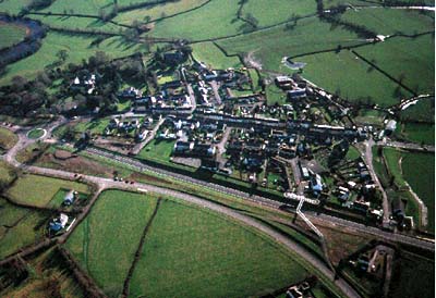
Abergwili is a compact nucleation within the Tywi floodplain just above the level of the alluvium, the core of which is a single property row each side of the A40(T) road which follows the line of the Roman road through the Tywi Valley. The south-western quarter of the area is occupied by St David's Church, with a large yard, and by the former Bishop's Palace with its park, now open to the public. Of the properties, those immediately north of the church appear to represent medieval burgage plots. There has been 20th century infill but the embankment of the former LNWR railway line forms a barrier to development to the north.
Recorded archaeology is mainly represented by built features but includes a possible round barrow to the north-west of the area.
Buildings in the historic core either side of the A40(T) are small houses of rather poor quality, and in their present form largely from the 18th- and 19th-century, and mainly terraced; however, earlier features have been noticed in a number of examples. The church was rebuilt in 1840-43 (Ludlow 1998) and is a Grade B listed building, while the old Bishops Palace is Grade II listed, thought to have been rebuilt much in its pre-1903 form. Also in the area are a former turnpike tollhouse, Abergwili railway station, a chapel, the school, the old vicarage and a council estate,and late 20th-century housing in a variety of styles and materials.
This is a well-defined landscape area distinct from the farmland on all sides.