|

179 LLANGYNOG - LLANGAIN 
GRID REFERENCE: SN 355152
AREA IN HECTARES: 4058.00
 Historic Background
A large area which was formerly divided between the lordships of Llansteffan
(Penrhyn commote) and Carmarthen (Derllys commote, specifically Maenor
Gain). This area was re-organised under manorial tenure between 1109 when
Carmarthen Castle was founded (James 1980, 23), and 1146 with the establishment
of the castle at Llansteffan (Avent 1991, 168-72). Llangynog may be an
important pre-Conquest religious centre with its circular churchyard and
associated large cropmark enclosures in neighbouring fields (Ludlow 1998),
but is now represented by a 19th-20th century dispersed settlement lying
1 km from the church, which was formerly a chapelry of Llansteffan parish.
Llanllwch - the demesne manor of Carmarthen - lay to the north (Area 181),
and some of the neighbouring land within Area 179 may also have been held
as demesne; within the manor itself significant areas of former ridge
and furrow have been noted. The presence of arable is recorded at Alltycnap
at the very north end of the area which, as 'le Cnap', belonged to the
Augustinian Priory of St John at Carmarthen (James 1980, 42). The name
'Parc-y-splots' immediately to the south indicates the former practise
of ridge and furrow. Maenor Gain appears to have been coterminous with
the present parish of Llangain which, however, is a Post-Medieval creation.
St Cain (Keyne), Llangain was formerly a chapelry belonging to Carmarthen
Priory but may represent a pre-Conquest foundation (Ludlow 1998). Between
1115 and 1147 a ploughland ie. 120 acres at 'Egliskein' (Llangain) was
granted to Carmarthen Priory by the lord of the manor Alfred Drue (Jones
1991, 4). The present village, however, is entirely later Post-Medieval
in origin (Jones 1991, 3). It has been suggested that the caput of the
manor was either at Green Castle, a 16th- or early 17th-century mansion-house
site overlooking the Tywi estuary associated with a landing-place, or
at a small motte-and-bailey that formerly existed nearby (ibid.). An area
held as common land lay immediately south of Alltycnap (James 1980, 42)
and four further areas of common had largely been enclosed by the early
19th-century (Llansteffan, Llangynog and Llangain tithe maps), the enclosure
around Glog-ddu and Llwyn-gwyn probably as a result of squatter settlement.
A large portion of the northern part of the area is labelled 'Forest'
by Rees (1932) but within the area lay Cwrt Malle, a moated site held
of Maenor Gain, granted to Robert de Malley, a former deputy Justiciar
of South Wales, in 1312 (James 1988, 108). It later passed to the Philipps
of Picton Castle. Substantial holdings dating from at least the 17th century
are known to have existed at Cwrt Hir, Gilfach ap Rosser, Maes Gwyn, Pant-yr-athro,
Pilroath, Wern Corngam and Wern-ddu (Jones 1987), but none of the present
farms retain earlier features and did not form large estates. Cored Roth
is the site of a Medieval fish-weir and watermill (Rees 1932), the latter
later becoming a woollen factory (Jones 1991, 3). Otherwise there was
little industry, and only scattered 19th- and 20th-century settlement.
Llangain is the only substantial settlement cluster, and the fringes of
its very small historic village core have experienced extensive housing
development in recent years. To the south at Pant-yr-athro is a holiday
complex.
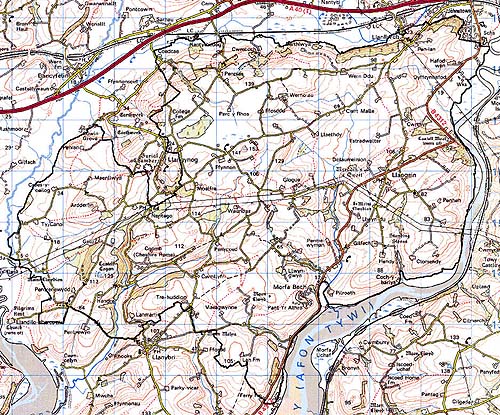
Base map reproduced from the OS map with the permission
of Ordnance Survey on behalf of The Controller of Her Majesty's Stationery
Office, © Crown Copyright 2001.
All rights reserved. Unauthorised reproduction infringes Crown Copyright
and may lead to prosecution or civil proceedings. Licence Number: GD272221
Description and essential historic landscape components
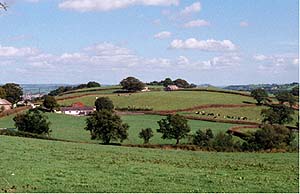
This very large historic landscape character area of undulating and hilly
ground which rises from sea level against the River Tywi to the east and
the River Taf on the southwest, achieves a maximum height of over 140
m along its northern fringes. The northern boundary of the area is defined
by a north-facing scarp slope, and many deeply incised streams within
the area have produced further steep-sided valleys and hills. Despite
its large area, the Llangynog-Llangain historic character area is remarkably
coherent, consisting in the main of dispersed large farms set in a landscape
of small- to medium-sized fields. Field boundaries comprise earth banks
topped with hedges. Hedges survive in a variety of conditions; generally
they are well maintained, but tending to become overgrown and neglected
on the northern, higher levels. Wire fences usually supplement hedges.
Distinctive hedgerow trees are not common except on the eastern side.
Apart from the higher levels to the north where there is some rushy ground,
poor quality grazing and even a small peat bog, almost all farmland in
this area consists of improved pasture. Broadleaf woodland which cloaks
many of the steep valley sides and may be ancient has been supplemented
since the Second World War with conifer plantations; this gives a wooded
aspect to parts of the northern and eastern fringes of the area. The dominant
settlement pattern is one of dispersed farms and other dwellings, but
there is a nucleated development at Llangain and dispersed modern housing
along the roads close to Carmarthen.
Recorded archaeology from such a large landscape area takes in a range of sites from all periods. However, all features relate primarily to agricultural land-use.
St Cynog, Llangynog, is a Medieval church, while St Cain, Llangain was rebuilt in a slightly different location from its predecessor in 1871 (Ludlow 1998). Important sites within the area include Cwrt Malle which represents one of only four moated sites in Carmarthenshire. Another possible moated site lay between Cwrt Malle and Wern Congam (James 1988, 107) and there are 16th- or 17th-century domestic remains at Green Castle. However, the only listed buildings are the Grade II listed house at Fern Hill and its Grade II listed stables. Farmhouses are generally stone-built, two-storey, three-bay of 19th century date, and mostly in the vernacular tradition, though there are examples in the 'polite' Georgian style. With such a large area there is clearly a variety of outbuildings associated with the farms, but most are fairly substantial, stone-built and 19th century, often of two or more ranges and sometimes arranged semi-formally around a yard. Most farms have large modern agricultural buildings. Modern housing in a variety of styles and materials is concentrated in small estates at Llangain and dispersed along the roads close to Carmarthen, though there is a scatter of recent dwellings right across the landscape.
A large but well-defined historic landscape area, distinct from the smaller former strip fields to the south, the larger irregular enclosures to the south-west, the unusual and undated system of very large, regular square enclosures to the west, the dry valley and raised bog to the north, and the saltmarsh of the Tywi estuary to the east.