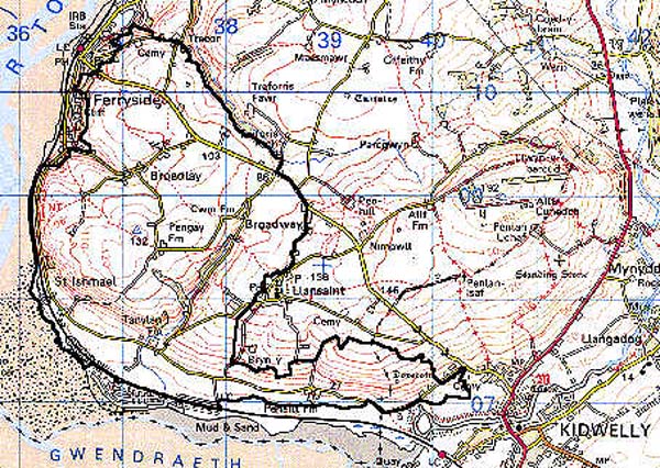
Home > Historic Landscape Characterisation > Carmarthen Bay Estuary Area > |

 ST ISHMAEL
GRID REFERENCE: SN 382088
AREA IN HECTARES: 723.90
Historic Background
An area possibly referred to in a pre-Conquest source when St Oudoceus was attacked by the wild men from 'the rocks of Pen Allt', whilst making his way to a crossing of the Tywi estuary (Davis 1989, 27). The parish church of St Ishmael probably also has pre-Conquest origins, but was first mentioned in 1115 when it was granted to Sherborne Abbey, Dorset, of which St Mary's, Kidwelly, was a cell (Ludlow 1998). The Medieval holding of St Ishmael was a foreignry of Kidwelly Lordship (Rees 1953, 175-212) centred upon the demesne manor of St Ishmael (Rees 1932), the nucleus of which may have lain in the vicinity of the present parish church where the remains of a Medieval settlement of some nature lie beneath High Water Mark immediately west of the church (Nigel Page, ACA pers. comm.). Nearby is an area of former common-land. Alternatively, the manor-house may be represented by Penallt House, a building thought to be a grange of Kidwelly Priory by Rees, 1932, but with remains of a purely secular nature, chiefly from the 16th century (Davis 1989, 27-33). Penallt was the home of the important Dwnn family, one of Wales' leading gentry families and commentators, from at least 1393 when John Dwnn was described as 'of Pennolth' (Jones 1984, 145), but had been abandoned long before 1800 (Davis 1989, 27). The 18th century mansion at Pengay represents a third contender for the manor-house site (Jones 1984, 148). The landscape area is crossed by the Kidwelly to Ferryside road which is marked as a Medieval route - 'The Ferryway' - by Rees (1932). The coastal road along the foreshore, which passes both St Ishmael and Penallt, may also have early origins (Davis 1989, 27). These historically-important dwellings and farms provide the context for the development of the present landscape of medium-large, irregular fields, which may be derived from medieval strip fields, and were probably enclosed during the 17th century. The earliest map of the area, the St Ishmael tithe map of 1840, depicts a landscape much as today, with the present pattern of fields and scattered farmsteads. The present small settlement at Broadlay developed from a couple of labourer's cottages around the farm. Twentieth century development also includes the provision of Second World War defences at St Ishmael.
Base map reproduced from the OS map with the permission
of Ordnance Survey on behalf of The Controller of Her Majesty's Stationery
Office, © Crown Copyright 2001.
All rights reserved. Unauthorised reproduction infringes Crown Copyright
and may lead to prosecution or civil proceedings. Licence Number: GD272221
 Description and essential historic landscape components
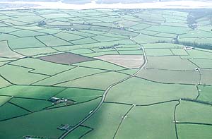
An area of medium-large, irregular fields, that possibly evolved from strip fields during the 17th century, lying between sea level and 125m. Now all supporting improved pasture, the fields are divided by banks with hedges in fair-good condition and generally well-maintained, though a few are overgrown and some are becoming derelict; those north-east of Ferryside exhibit some distinctive trees. Some roadside banks near the coast to the west of the area have stone facing. There are some small areas of woodland and scrub, particularly on the steeper coastal slopes around St Ishmael, but it is probably all secondary. A number of large, historically important farms lie in the area, but all are stone-built, slate-roofed and with modern outbuildings. Settlement is mainly dispersed, but the cluster of buildings at Broadlay has 19th century origins. The Tywi estuary foreshore has been re-shaped as a cutting for the GWR main West Wales line, which opened in 1852 and is still operational (Ludlow 1999, 28).
Despite the size of the area, the recorded archaeology is limited. Several possible Bronze Age standing stones are suggested by field names, and there is a possible Medieval cross. An Iron Age hillfort is present. Post-Medieval sites include farmsteads and cottages, a mill and millrace, sandpits, the railway, sea defences and a Second World War battery and lookouts at St Ishmael.
There are a number of distinctive buildings. The landmark Medieval parish church of St Ishmael is Grade B listed, and a Medieval dovecote at Coleman Farm is a Scheduled Ancient Monument and Grade II listed building. The 16th century Penallt mansion is Grade II listed, but the 18th century Pengay mansion is unlisted. Generally farmhouses in this area are 19th century, stone-built, two-storey and three-bay, with examples in both the vernacular tradition and the 'polite' Georgian style. Most farms have relatively large 19th century farm outbuildings, sometimes arranged semi-formally around a yard, as well as modern agricultural buildings. Modern residential development is limited to a few scattered dwellings and some ribbon development at Broadway.
This is a fairly distinct landscape area bounded by the Tywi estuary and Ferryside to the west, coastal marsh to the south, and an area of smaller, narrower enclosures to the east. Only the boundary with the area to the north is indistinct; the fields in the latter area are rather more regular.