Home > Historic Landscape Characterisation > Carmarthen Bay Estuary Area > |

153 LLANYBRI AND LLANSTEFFAN STRIP FIELDS 
GRID REFERENCE: SN 343120
AREA IN HECTARES: 427.60
Historic Background
The area comprises a substantial part of the parish of Llansteffan, to
the north-west of Llansteffan village and around the small nucleation
of Llanybri. Llansteffan had been established as an Anglo-Norman manor,
and the caput of the commote and Lordship of Penrhyn, by the mid 12th
century. It was a parish during the Medieval period, in which the former
chapelry of St Marys at Llanybri had its origins as a chapel-of-ease (Ludlow
1998). The dominant feature of the present landscape is a pattern of fields
which tend to be long and narrow with curved boundaries. These are particularly
concentrated south-west and north-east of Llanybri, and are the product
of the fossilisation of post-12th century open field strips within 17th-
and 18th-century field boundaries established under gentry families such
as the Lloyds of Llansteffan and Laques. The landscape can thus be contrasted
with that of Area 152 within which Post-Medieval enclosure, under the
same landowners, effaced any pattern of earlier field systems. Llanybri
was a demesne manor of the Lords of Llansteffan and Penrhyn and appears
to be an early nucleation around a central open space, adjacent to a chapel
dedicated to St Mary that had been established, as ‘Morabrichurch’,
by the 14th century at least (Rees 1932) and was, in the 16th century,
called ‘Marbell Church’ (RCAHM, 1917, 197). An area of common
land lay within the village and may have Medieval origins. Pendegy Mill,
some 700m west of the village, is the site of the Medieval ‘Mundegy
Mill’. Rees (1932) depicts Llanybri as a borough, and though the
designation is most unlikely the settlement did lie at the junction of
seven routeways. The landing-place of Llansteffan ferry which has possible
pre-Conquest origins (Davies 1989, 27) and was crossed ‘in a boat’
by Gerald of Wales in 1188 (Thorpe 1978, 138) lies to the east of the
area.
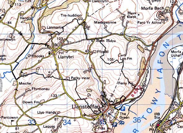
Base map reproduced from the OS map with the permission
of Ordnance Survey on behalf of The Controller of Her Majesty's Stationery
Office, © Crown Copyright 2001.
All rights reserved. Unauthorised reproduction infringes Crown Copyright
and may lead to prosecution or civil proceedings. Licence Number: GD272221
Description and essential historic landscape components
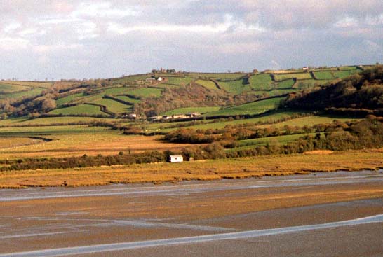
This historic landscape character area comprises a system of enclosed,
former field strips lying across a band of rolling hills that achieve
a height of approximately 100m close to the village of Llanybri, and run
down to sea level by the estuaries of the Taf and Tywi. Most land is farmed;
the majority is improved pasture, though there is a little arable. On
steep slopes are small stands of deciduous woodland, but trees are not
common, and essentially this is an open landscape. Settlements consist
of the hamlet of Llanybri and dispersed farms. Much recent residential
development in a variety of styles and materials on the edge of the historic
core has doubled or trebled the size of the settlement. Dispersed farms
are usually stone-built with a range of outbuildings, both stone-built
and modern. These farms are set in a landscape of small, irregular fields.
On historic maps and in certain areas on the ground it is possible to
detect enclosed strips in the modern field system - clearly the modern
system evolved out of an open field system. Enclosed strips survive best
on steep slopes to the north and east of Llanybri and to the west of Llansteffan.
Over recent decades, on flatter ground, there has been a tendency to merge
the enclosed strips into larger more regular fields, and it is more difficult
to detect the former presence of an open field system. Boundaries to the
fields consist of earth banks topped with hedges. Hedges are generally
in good condition, but on the steep slopes to the north of Llanybri they
are becoming very overgrown, and to the west of Llansteffan some are becoming
derelict.
Earlier features within the landscape include a scheduled Bronze Age standing stone which, during the medieval period, was a known landmark called ‘Welsh Cross’ (Rees 1932). There is at least one more standing stone, and two round barrows. An inscribed stone is possibly recorded in a place-name at Llanybri, and a spring/holy well lies to the south-east.
Distinctive buildings include the Grade II listed Medieval chapel of St Mary which exhibits a low west tower from the 16th century but has become ruinous since 1917, the 19th century Holy Trinity Church and a non-conformist chapel. The core of the settlement consists of stone-built farms, houses and cottages of probable 19th century date with a former inn and smithy; other buildings include Pendegy mill, a bridge, farms and cottages.
This historic landscape character area is similar to the area to the south, with scattered farms and medium-sized fields, and though the historical process that have helped form the two areas are different, the boundary is not well defined. A similar lack of definition exists between this area and the area to the north, and the area to the north-east. Reclaimed salt marsh provides a good boundary to the west, and Llansteffan village clear definition to the east.