Home > Historic Landscape Characterisation > Carmarthen Bay Estuary Area > |

 LAUGHARNE AND PENDINE BURROWS
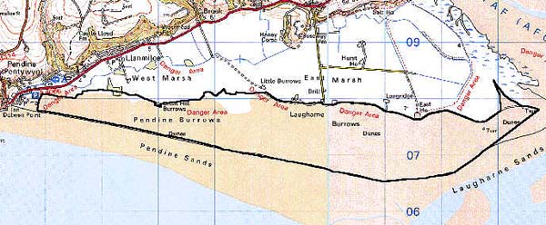

GRID REFERENCE: SN 280074
AREA IN HECTARES: 730.60
Historic Background
An area of sand dunes fronting Laugharne Marsh, which probably began to form in the second millennium BC in common with other coastal areas of South Wales (Higgins, 1933). The discovery early in the 20th century of shell middens in the dunes, seemingly associated with prehistoric finds, supports an early date for sand incursion (Cantrill, 1909). The dunes lay within the Lordship of Laugharne during the Medieval period, but were clearly of little economic use. The present system of an unbroken chain of dunes from Pendine to the Taf estuary is fairly modern. Terry James (1991, 148-51) has demonstrated that the Witchett Brook opened out through the dunes as late as the 1830s, when a dam and engine house were constructed across it. Since the Second World War a Ministry of Defence research establishment has used the dunes for tests, and many installations have been constructed within them.
Base map reproduced from the OS map with the permission
of Ordnance Survey on behalf of The Controller of Her Majesty's Stationery
Office, © Crown Copyright 2001.
All rights reserved. Unauthorised reproduction infringes Crown Copyright
and may lead to prosecution or civil proceedings. Licence Number: GD272221
Description and essential historic landscape components
This is a very extensive system of sand dunes, running for over 9 km from Pendine in the west to the Taf estuary in the east. It is 1km to 1.5km wide between Laugharne and High Water Mark. Historic landscape components are confined to the modern period and comprise many installations, buildings and tracks associated with the Ministry of Defence research establishment.
Recorded archaeology similarly mainly relates to the Ministry of Defence and to Post-Medieval drainage schemes but there is a possible settlement site, of unknown date (prehistoric?) and several findspots and middens.
Distinctive buildings are confined to the recent Ministry of Defence structures.
This is a distinct landscape area, and effectively separates Pendine beach and foreshore from the area to the north.