|

242 CWRT-Y-CADNO 
GRID REFERENCE: SN 689435
AREA IN HECTARES: 570.60
Historic Background
A narrow area following the valley floor of the Afon Cothi and its tributaries
the Nant Dâr, Nant-y-garth and Afon Frongoch. It once lay within Cwmwd
Caeo of Cantref Mawr, which remained an independent Welsh lordship until
1284 and largely retained native systems of tenure throughout the Medieval
period. The southern flanks of the valley bear physical evidence of Roman
gold mining in the form of leats and aqueducts that supplied the workings
found in Area 243. Within this area the pattern of small irregular fields
is unlike that in Area 241 where enclosure appears to have been a creation
of the Dolaucothi estate, and may be Medieval or early Post-Medieval in
date, like the ridge-and-furrow observed in similar fields in the neighbouring
Area 248. The place-name Ty'n-y-coed suggests the former presence of a
contemporary settlement. The Dolaucothi estate did, however, impact on
the area in a number of ways. It contains four significant gentry houses,
all associated with the estate to varying degrees, of which Abermangoed
had been established by the late 17th-century when 'the capital messuage
and lands of Tir Abermangoed' belonged to the Jones family (Jones 1987,
3), but reverted to the Dolaucothi estate by 1733 and bears the architectural
signature of the estate. Llandre Griffith meanwhile, was in 1701 the home
of a branch of the Johnes of Dolaucothi and was later held in joint ownership
with Abermangoed (Jones 1987, 103). Pant-coy, which burnt down in 1839,
was owned in 1840 by the Earl of Cawdor but became part of the Dolaucothi
estate and was the home of John Harries (1785-1839) and Henry Harries
(1816-1862), wizards, soothsayers and conjurers, well-known throughout
south Wales. Cefngarros was another estate farm with the architectural
signature, formerly renowned for the nearby sulphur springs. The Cothi
valley road had long been an important drovers route, and a chapel was
constructed alongside the road at Cwrt-y-cadno. A school had been added
by the late 19th-century but despite these focii and the patronage of
the estate, the settlement village never developed as a nucleation with
dwellings. There has been little recent development but there are late
20th-century coniferous plantations on Allt Dinbeth and Alt Ty'n-y-coed.
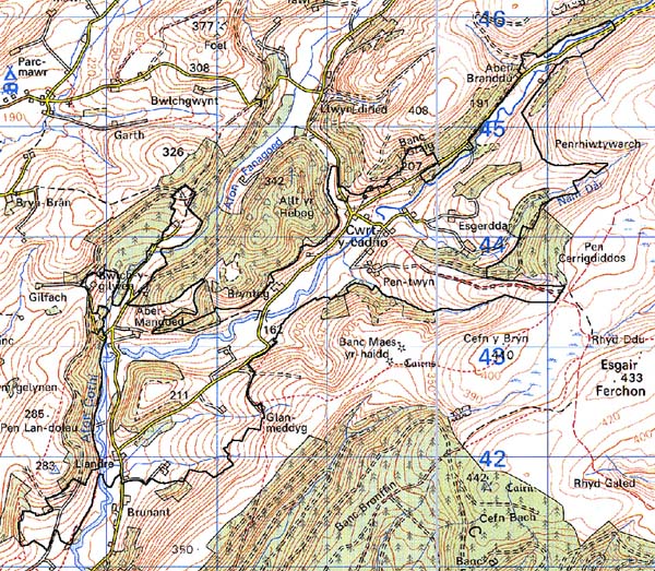
Base map reproduced from the OS map with the permission
of Ordnance Survey on behalf of The Controller of Her Majesty's Stationery
Office, © Crown Copyright 2001.
All rights reserved. Unauthorised reproduction infringes Crown Copyright
and may lead to prosecution or civil proceedings. Licence Number: GD272221
Description and essential historic landscape components
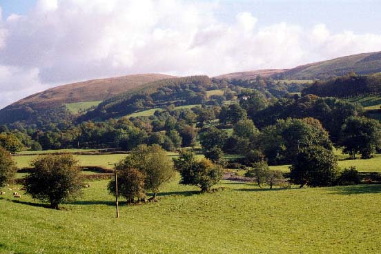
Cwrt-y-cadno character area lies in the upper Cothi valley and includes
the valley floor which lies between 150 m and 190 m, and the valley sides
that have been enclosed into fields up to approximately 220 m. Essentially
this is a landscape of dispersed farms, small irregular fields and scattered
woodland. The small irregular fields are divided by earth banks topped
by hedges. Apart from along roads, lanes and tracks the hedges are generally
in poor condition and are either overgrown, lines of straggling bushes
or derelict. Wire fences provide the main stock-proof boundaries. There
are many distinctive hedgerow trees, and these together with the numerous
deciduous woods (particularly prominent on steep valley sides) and the
several small- and medium-sized conifer plantations lend a wooded aspect
to many parts of this area. Farmland land-use is almost entirely improved
pasture, with small pockets of rougher grazing and rushy ground. Transport
links are local only - minor roads, lanes and tracks. The settlement pattern
is one of dispersed farms and other dwellings. There is no aggregate settlement.
Farmhouses and outbuildings of the Dolaucothi estate provide a distinctive
architectural signature. These are 'pattern-book' buildings dating to
the 1850s, and are built of coursed stone and have casement windows with
diamond panes. Farmhouses are of two storeys and three bays, and the central
bay normally contains the front door projecting forward of the facade
with a separate gable. The farm buildings of these farms tend to have
a semi-formal arrangement in relation to the house, i.e. around a courtyard.
Earlier farmhouses in the area are generally of late 18th- or early 19th-century
date, are of a similar style and size to the estate examples but in a
vernacular tradition, and usually rendered. Farm buildings associated
with these have a informal arrangement with the house. Central to the
area is Cwrt-y-cadno chapel. There is virtually no modern residential
development.
Recorded archaeology comprises Roman leats and aqueducts, a house platform and a possible Medieval/Post-Medieval settlement site, a possible cemetery of unknown date and an unknown cropmark.
There are a number of distinctive buildings, many of them bearing the signature of the Dolaucothi estate. Cefn Coed Mawr, Grade II listed, is mid-late 18th-century, remodelled in the later 19th century, with good vernacular features and group value with its farm outbuildings. The barn is also Grade II listed, as is the early 19th-century cowshed with an integral lofted stable. Cefngarros, from c.1845, is typical of several former Dolaucothi estate farmhouses in the area and Grade II listed. Brynteg is Grade II listed, built in 1843 and probably influenced by the architectural pattern-books; the barn range is also Grade II listed. Pant-coy is Grade II listed being a late 19th-century cottage formed from earlier farm building; the previous house burnt down in 1839. The outbuildings are also Grade II listed. Cwrt-y-cadno chapel, built in 1899, is of good quality, adjacent to a K6 telephone box. There are several fords and bridges, and mill sites.
This area is well defined to the south, north and east where it borders steep valley sides, forestry plantations or open moorland. Definition is less good to the southwest.