Roads
In the 18th century industrial manufacturing on the south side of the mountain had not yet begun. On the north side however, great changes in agriculture to increase production and efficiency were happening. Lime played an important part in this 'agricultural revolution' because it was used as a soil improver for bringing new land into cultivation and increasing crop yields. The lime industry expanded rapidly to supply the increase in demand for lime from farmers.
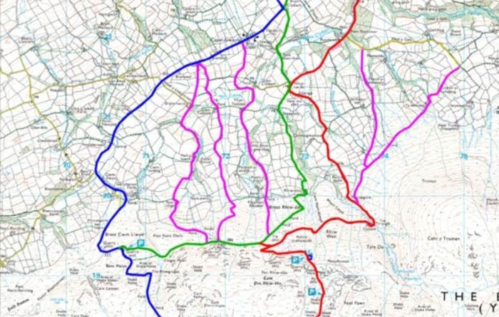
It was difficult to transport lime on the old roads, so 'turnpike trusts' were formed to raise finance to build new roads and maintain them. By looking at old maps and documents we can see how the lime industry on the Black Mountain has influenced the development of the road network in the area.
© Brecon Beacons National Park Authority Crown copyright and database rights 2012 Ordnance Survey 100019322
The earliest road across the mountain was called the 'Bryn Road' (marked in blue), and is now sometimes called the 'Roman Road'. In 1779 the Llangadog Turnpike Trust was formed. They repaired the road up as far as the Brest Cwm Lloyd lime kilns. The pink routes are old tracks leading up to the quarries.
As the limestone quarrying moved eastwards along the outcrop, a new road was built by the Turnpike Trust (marked in green. By 1819 the old route across the mountain had been abandoned and a new road was built across the mountain (the present day A4069 - marked in red). |