|

279 BRYNBERIAN - MIRIANOG 
GRID REFERENCE: SN112360
AREA IN HECTARES: 822.2
Historic Background
A large area of modern Pembrokeshire forming an east-west band along the
northern edge of Mynydd Preseli, within the medieval Cantref Cemaes, Uwch
Clydach commote. Cemaes was brought under Anglo-Norman control in c.1100
by the Fitzmartins who retained it, as the Barony of Cemaes, until 1326,
when they were succeeded by the Audleys. The Barony was conterminous with
the later Hundred of Cemais, which was created in 1536, but many feudal
rights and obligations persisted, some until as late as 1922. This character
area lies within Nevern, Meline, Eglwyswen and Llanfair Nant Gwyn parishes.
Nevern parish was a borough of the barony, while Meline and Eglwyswen
(Whitchurch) - within which Llanfair Nant Gwyn formerly lay - were held
immediately of the Lords of Cemaes. The character area forms the northern
edge of the great moorland common of Mynydd Preseli, on which the freeholders
of Cemaes held rights of pasture and turbary from the late 13th-century.
The area has been settled since at least the mid 14th-century, when the
vills or farmsteads of 'Melinay' (on the fringe of Preseli), Rhosyfarced
and Rhosdwarch were mentioned. The entire area comprises smallish rectangular
enclosures of irregular form which suggest that - with the exception of
Brynberian - it was all systematically enclosed during this period, rather
than as the result of piecemeal encroachment onto common land. However,
the tithe maps of 1841-3 label some fields and settlements, along the
fringe of the common as 'encroachments', indicating that they were newly
established. The moorland boundary is also shown as more irregular than
today. The many isolated fields shown just outside the enclosed land on
the tithe maps, either have been incorporated within the enclosed land
or abandoned. Of the other major farmsteads, Mirianog is also early and
is first mentioned in 1412 when 'the messuage of Breuanog-fawr' was granted
to Owain ap Gwilym Ddu of Henllys; it comprised 2 messuages in 1786, and
4 in 1950. Helygnant was in existence by 1515, and comprised 2 or 3 tenements
each of around 15 acres which in 1597 were owned, as 'Lygnant' or 'Plas
Helignant', by Thomas Griffith ap Ieuan Jenkin of Mynachlog-ddu, yeoman,
and had by the 18th century been acquired by the Warrens of Trewern. The
remainder of the farms were established in the 18th- and early 19th-century.
The character area has been crossed by the main Haverfordwest-Cardigan
route since the medieval period, via Brynberian bridge which was mentioned,
as 'Pont llin birian', in c.1600. The road was later turnpiked and is
now the B4329. Settlement at Brynberian occurred around an area of unenclosed
common, and appears to have origins after the Independent Chapel was established
in 1690. Though the village is of no great size it is now the largest
within this character area, having been promoted by the small woollen
factory that was operational here during the 19th century.
Base map reproduced from the OS map with the permission
of Ordnance Survey on behalf of The Controller of Her Majesty's Stationery
Office, © Crown Copyright 2001.
All rights reserved. Unauthorised reproduction infringes Crown Copyright
and may lead to prosecution or civil proceedings. Licence Number: GD272221
Description and essential historic landscape components
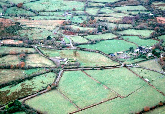
Brynberian - Mirianog historic landscape character area is a wide band
of enclosed farmland bordering the northern side of Mynydd Preseli. The
general trend of the land is a downward slope from north to south, from
over 200m down to approximately 120m, but included in this area is the
narrow gorge-like valley of the Afon Nevern and Afon Brynberian and an
east-facing shelf of land to the west. Fields are small and irregular.
A mixture of boundary types is present. All contain a proportion of stone;
they range from dry-stone walls on the eastern side of the Nevern/Brynberian
valley, through to stone-faced banks, stony banks and earth and stone
banks. Some bank foundation stones are massive and could be termed monoliths.
Most banks are topped with hedges, but apart from those alongside roads
and tracks and in a few of the lower-lying areas, these are not well maintained.
At higher levels hedges are entirely absent; most are either overgrown
or reduced to lines of straggling bushes and small trees. Deciduous woodland
on the steep valley sides and small stands of scrubby woodland together
with the overgrown hedges lends a wooded aspect to parts of the landscape,
particularly the Nevern/Brynberian valley. Agricultural land-use is almost
entirely pasture, the greater part of which is improved, but unimproved
grazing is present as well as tongues of wet rushy ground extending out
from Mynydd Preseli. The settlement pattern is of dispersed farms, cottages
and houses, with a small, loose clustering of dwellings at Brynberian.
Most dwellings are 19th century of one, one-and-a-half and two storeys.
They are stone-built (cement rendered and bare stone), slate roofed and
of three bays. Rarer house types include a two storey stone built dwelling
in the polite Georgian style. Some mid-to-late 20th-century brick built
houses are also present as well as other late 20th-century houses. Farm
outbuildings, where present, are also quite small. Usually a single 19th
century stone-built range is present, sometimes in combination with a
mid 20th-century corrugated-iron structure and/or small late 20th-century
steel, asbestos and concrete buildings. There are several deserted farms
and cottages, particularly on the fringes of Mynydd Preseli. Also in this
area are Rhostwarch house and outbuildings, probably of 18th century date
and both Grade II listed, an 18th- or early 19th-century pigsty at Maenoffeiriad
which is also Grade II listed, Brynberian Independent Chapel, established
1690, rebuilt in 1808 and 1843, and restored in 1882, also Grade II listed,
and Brynberian woollen factory which has closed but the mill is Grade
II listed. Brynberian bridge had been established by 1600 when it was
mentioned by George Owen. Apart from the B4329 which crosses the eastern
end of this landscape, other transport elements consist of winding lanes
and tracks flanked by high boundary banks.
Recorded archaeology is fairly diverse. It comprises a possible neolithic chambered tomb and a group of neolithic and bronze age findspots, a possible standing stone, round barrow, and another findspot from the bronze age. There are two scheduled iron age hillforts, one with an associated prehistoric findspot. There is a dark age inscribed stone, and a possible enclosure? ('bangor' place-name). The medieval settlement of 'Melinay' stood on the fringe of Mynydd Preseli, several kilometres south of the parish church named from the settlement, and its name may therefore be derived from medieval windmills. At nearby Mirianog is a possible medieval corn-drying kiln. Post medieval features include quarry features, mills, wells and bridges.
This historic landscape character area is very well defined. To the south it is bordered by the open moorland of Mynydd Preseli, and to the west, east and north lies the lower-lying richer farmland of Eglwyswrw.
Sources: Charles 1992; Howells 1977; Jones 1996; Lewis 1972; Meline tithe map and apportionment, 1841; Nevern tithe map and apportionment, 1843; Whitchurch tithe map and apportionment, 1841; Rees 1932; Sambrook 1997