Home > Historic Landscape Characterisation > Upland Ceredigion > |

 YSTRADMEURIG
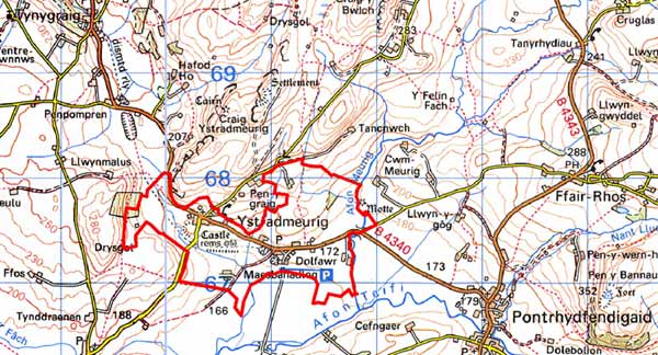
GRID REFERENCE: SN 707674
AREA IN HECTARES: 167.7
Historic Background
The early history of this area has not been researched. The church of St John the Baptist was granted to the Knights Hospitaller in 1158 (Ludlow 1998). There is also a possible hospice site at Mynachdy, perhaps indicating that land was also included in the grant, although this place-name may refer to use of the site by the monks of Strata Florida Abbey - this part of the area may have lain within the grange of Mefenydd. In 1113 Richard de Clare founded the castle of Ystradmeurig -one of only three stone castles in Ceredigion. It changed hands several times in its short life, before being demolished in 1207 (King 1956). It is unclear whether a settlement developed close to the church and/or castle in the Medieval Period. A small group of substantial 18th and early 19th century stone built dwellings at Ystradmeurig and the foundation of a grammar school in the churchyard in 1803 testify to the growth of a community in the later post-Medieval Period. Late 18th century estate maps (NLW Crosswood Vol 1, 62, 66) show a landscape broadly similar to that existing today, although at that time there appears to have been a slight difference in size between those fields close to farmsteads than those more distant - the closer fields generally being smaller and more irregular in shape. Presumably this is a reflection of the chronological sequence of enclosure, with the larger fields having been created at a later date in the late 18th century. Much subdivision of the larger enclosures had occurred by the tithe survey (Spytty Ystrad Meurig Tithe Map and Apportionment, 1843) and the difference in enclosure size had largely been lost. Included in this area is the historic garden of Bron-meurig (Welsh Historic Gardens Database). In 1866, the Milford Manchester Railway, linking Tregaron with Aberystwyth was opened, with a station at Ystradmeurig. It closed in the 1960s.
Description and essential historic landscape components
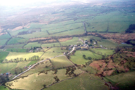
This is an irregular-shaped landscape area situated on south and southwest-facing gentle slopes and has a height range of between 160m in the southeast and 230m in the north. It consists of a system of irregular fields, with a settlement pattern of scattered farms and the village of Ystradmeurig and the hamlet of Tynyffordd. Field boundaries are of earth banks topped with hedges. These hedges are in good condition on the lower levels, but become increasingly derelict at higher elevations, and are augmented with wire fences. At the highest levels around Mynachdy the earth banks are slight and the hedges have been replaced with wire. Improved pasture dominates land-use, with very little rougher grazing. There are some small stands of deciduous woodland.
Local stone is the principal, traditional building material. This is often roughly squared and coursed on houses and rubble on farm buildings, with surface treatment such as limewash, paint or cement. Slate is universally used on roofs. Ystradmeurig village consists of a small cluster of buildings, with the listed late 19th century gothic church and an early 19th century gothic grammar school at its centre. Houses here are 19th century and in the typical regional Georgian vernacular tradition. However, several of the houses have very strong Georgian traits, rather than the more usual mixture of Georgian vernacular, which gives a more formal appearance to the village than many others in the region. Several of these houses are farms and have ranges of 19th century outbuildings set semi-formally around yards, Many of these outbuildings are not now used or have been converted to other uses. Modern agricultural buildings are not prominent component of this landscape. There is at least one modern house in the village.
Tynyffordd is a dispersed linear settlement consisting almost entirely of late 20th and early 21st century houses and bungalows. Other buildings scattered across the area comprise farms with mid-to-late 19th century houses and a late 19th century stone-built shop/house with brick detailing.
The recorded archaeology in the area is varied. Ystradmeurig Castle earthworks represent the major site in the area. Other definite or possible Medieval sites are described above. Artefacts of Iron Age and Bronze Age date suggest a greater time-depth to this landscape than is readily apparent from the surface evidence.
To the northeast and northwest the borders of this area
are fairly well defined by unenclosed land or large enclosures. An area
characterised by small enclosures bounded by dry-stone walls lies to the
north. There is no clear demarcation between this area and the regular
enclosures found in areas to the southeast and southwest. To the south
is the clearly defined area of Cors Caron.
Base map reproduced from the OS map with the permission
of Ordnance Survey on behalf of The Controller of Her Majesty's Stationery
Office, © Crown Copyright 2001.
All rights reserved. Unauthorised reproduction infringes Crown Copyright
and may lead to prosecution or civil proceedings. Licence Number: GD272221