Home > Historic Landscape Characterisation > Upland Ceredigion > |

 HAFOD
HAFOD
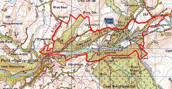
GRID REFERENCE: SN 784743
AREA IN HECTARES: 401.6
Historic Background
In the Medieval Period, this part of the Ystwyth valley lay in Strata Florida’s Grange of Cwmystwyth (Williams 1990, 57). By 1513 Hafod Uchdryd was leased as a farm, and a rent roll of 1545-50 indicates that all farms of the former grange were leased out and farmed as individual units (Morgan 1991, 5-7). This suggests that by the later Middle Ages the land was not farmed by monks, but was perhaps run along similar lines to later secular estates. Included in this area is the site of Peiran Mill (Macve 1998). The Herbert family acquired part of the grange of Cwmystwyth, including Hafod Uchdryd -later just Hafod - in the mid 16th century (Morgan, 1997, 28). A nucleus of a small estate was thus formed. It was not until 1783 when Thomas Johnes took up residence that the name Hafod became synonymous with the naturalistic picturesque movement. Johnes set about transforming the estate. More land was purchased or exchanged, a mansion constructed, gardens laid out and walks linking natural and built attractions constructed, which became the main reason for Hafod’s fame. Vast tracts of upland were planted with trees and experimental farms established. No tourist journey to Wales in the late 18th or early 19th century was complete without a visit to the wonders of Hafod. Artists and writers were also attracted by Hafod’s fame. The mansion and other attractions were painted or drawn by many artists. Of particular note are the set of paintings by John ‘Warwick’ Smith and the view of the mansion by J M W Turner, though is debatable whether the latter ever visited Hafod (Macve 1993, 3-7). George Cumberland’s 1796 celebrated description of Hafod is well known. Hafod has continued to attract the attention of artists and writers: John Piper visited and painted several views before World War Two, and there is a wealth of contemporary literature. Of particular note are Elisabeth Inglis-Jones’s Peacocks in Paradise, and many notes and articles in the Friends of Hafod Newsletter. The Duke of Newcastle purchased the estate in 1835 (Evans 1995). Later in the 19th century it was acquired by the Waddinghams. These later owners ran the estate on more conventional lines, and many of the gardens, walks and summerhouses so beloved of Johnes fell into disuse. In the 1950s the Forestry Commission bought the estate and embarked upon a programme of afforestation. Also included in this area is the historic garden of Cae’r Meirch (Welsh Historic Gardens Database).
Description and essential historic landscape components
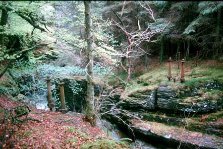
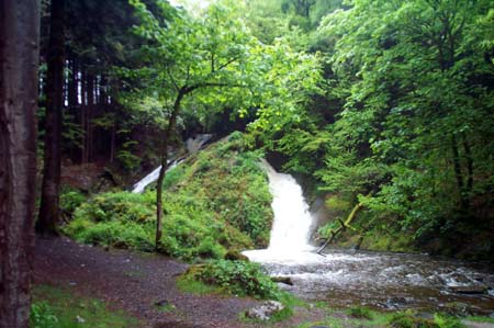
This is the core area of the Hafod estate. Cataracts and a narrow gorge characterise the Ystwyth valley at the eastern end of the area, and at the western end is a narrow flood plain in a steep-sided valley. The river falls by about 60m within this area down to a minimum of 140m. The valley sides rise to over 300m. Rapidly flowing streams descend the valley sides in a series of waterfalls before meeting the Ystwyth. Valley sides are heavily cloaked in 20th century broadleaf and coniferous plantations with just a few stands of Johnes’s planting - mostly beech - surviving. Open areas are few and consist of meadows around the site of the former mansion and improved (ADAS experimental grassland) pasture on a river terrace near Dologau farm, and occasional fields of improved grazing on the periphery of the area.
Prior to afforestation, enclosed land was confined to the higher, less-steep valley sides and terraces alongside the Ystwyth and tributary streams. It was generally not present on the steeper slopes. Dry-stone walls with capstones set at 45 degrees are a distinctive boundary type. Broadleaf trees, now mature, have been planted at regular intervals of 12 -15m alongside some of these walls. Both construction of the walls and tree planting were the work of Thomas Johnes. Other boundaries consist of earth banks or earth and stone banks, both topped with hedges. The hedges are in varying degrees of preservation; some are maintained and stock-proof, other have all but disappeared. All are supplemented with wire fences. Roadside, mortared stone walls, possibly the work of post-Johnesian estate owners can be found in a few locations.
Hafod mansion was demolished in 1957, but its site (now rubble), outbuildings and terraces marking former gardens, are prominent features of the landscape. There are several listed buildings at Hafod, mostly estate built dwellings and other structures such as a lodge and gates, a late 19th century haybarn, late 19th century stables, two cottages, a walled kitchen garden, an icehouse, a monument and a pair of imposing late 19th century dressed stone dwellings by Pont-rhyd-y-Groes bridge. Other buildings include two 19th century farmsteads (no longer working farms) with houses in the typical late 19th century Georgian vernacular style – gable end chimneys, central front door, and two windows either side of the door. One of the above has vernacular traits including low eaves, small windows and one chimney larger than the other. The stone-built outbuildings of these farms consist of one or two small ranges. There are also a few semi detached late 19th century two storey worker houses.
Other Johnesian built elements are less obvious, but nevertheless comprise important landscape components, and include walks laid as earthwork terraces on valley sides and as rock-cut shelves on cliffs and rocky outcrops. The estate drive system has been overlain and incorporated into forestry drives, except in one instance. Four elements of the picturesque landscape have been designated Scheduled Ancient Monuments.
The recorded archaeology consists almost entirely of elements of the 18th and 19th century picturesque and agricultural landscape. Apart from a Medieval mill site, no time-depth to the landscape is provided by the archaeology.
The borders of this area are well defined. To the south
and north is unenclosed land, forestry or high ground consisting of large
enclosures. To the west and east is un-forested enclosed land.
Base map reproduced from the OS map with the permission
of Ordnance Survey on behalf of The Controller of Her Majesty's Stationery
Office, © Crown Copyright 2001.
All rights reserved. Unauthorised reproduction infringes Crown Copyright
and may lead to prosecution or civil proceedings. Licence Number: GD272221