Home > Historic Landscape Characterisation > Upland Ceredigion > |

 CAPEL BANGOR
GRID REFERENCE: SN 660800
AREA IN HECTARES: 330.8
Historic Background
The history of this area has not been researched. The place-name ‘Bangor’ is presumed to refer to a pre Anglo-Norman ecclesiastical establishment. There is no other evidence to support this. The maes element of Maes Bangor may indicate the former presence of an open- or sub-divided field system, although there is no documentary evidence for this. However, the present pattern of small irregular fields and dispersed farmsteads may have evolved from such a system in the later Medieval Period or early modern period. It is clear that by the time of the first large-scale mapping of the area, the tithe map of 1845 (Llanbadarnfawr parish), the current settlement pattern of dispersed farms and small fields had been established. Superimposed onto this agricultural landscape is one of rural industry and crafts. Capel Bangor village in 1845 consisted of five or six dwellings at ‘Pandy’, presumably indicating a fulling mill, and a smithy, with a ‘Factory’ located upstream. A chapel was constructed here in 1790 (Percival 1998, 517), and later a church and another chapel. The village continued to develop throughout the second half of the 19th century and the 20th century. A by-pass has been constructed to avoid the core of the old village.
Description and essential historic landscape components
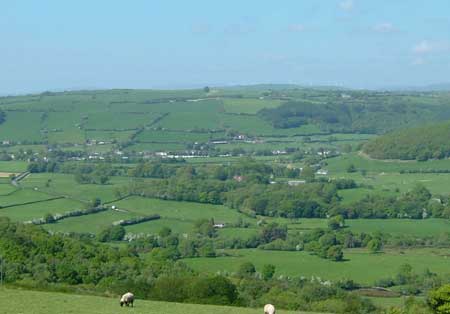
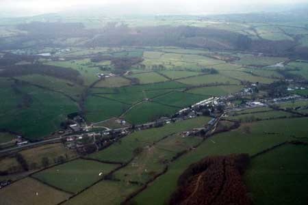
This area encompasses a terrace of the Afon Rheidol at about 30m-50m OD and the lower valley sides up to about 170m. Agricultural land is almost entirely composed of improved pasture, with hardly any rougher ground and no arable. The underlying settlement pattern is of dispersed farms. Included in the area are the early 19th century red-tiled roofed listed mansion of Glan Rheidol and its historic garden. However, stone, rendered or left bare, is the main building material, with slate for roofs. Farmhouses are mainly 19th century in date, stone built and in the typical Georgian vernacular style of the region. Farms have two or three ranges of 19th century stone outbuildings and substantial modern concrete and steel agricultural buildings. Superimposed over this agricultural pattern is the 19th and 20th century village of Capel Bangor. At its core along the old road through the village are worker houses, including terraces of single-storey cottages as well as the more regionally typical two-storey late 19th century detached and semi detached worker houses of bare stone with brick detailing. A 19th century Georgian style church, a chapel with attached house and schoolroom (all listed) also lie in the village. Several substantial late 19th century stone and brick built gothic villas lie close to the village core. These seem to be influenced by the buildings of Aberystwyth, which lies a little distance to the east, and do not have an obvious agricultural function: they are probably lead mine managers’ or owners’ houses. The old village core has now been by-passed. Petrol stations and other services, shops, modern houses, small housing estates and a school have developed along or close to this new road.
Field patterning comprises small irregular enclosures. The boundaries of these fields are of earth banks topped with hedges. Hedges are generally well maintained on the river terrace with only a small percentage neglected. On higher ground they are less well managed and a larger proportion are becoming derelict. Wire fences supplement most hedges. Deciduous woodland and individual trees of parkland close to Glan Rheidol lend a wooded appearance to this part of the area. Remains of small metal mines lie close to the northern boundary.
The recorded archaeology of this area consists mainly of post-Medieval domestic and industrial buildings and the remains described above. Bronze Age finds are the only indication of pre Dark Age occupation in this area.
This is a particularly difficult area to define as many
of the neighbouring areas contain similar historic landscape characteristics.
To the east the historic landscape character areas are different, though
an exact boundary cannot be drawn. Higher ground of larger enclosures
and less settled land to the north provides better boundary definition,
but again no exact boundary can be drawn. The historic landscape area
to the west has yet to be described.
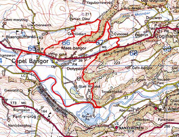
Base map reproduced from the OS map with the permission
of Ordnance Survey on behalf of The Controller of Her Majesty's Stationery
Office, © Crown Copyright 2001.
All rights reserved. Unauthorised reproduction infringes Crown Copyright
and may lead to prosecution or civil proceedings. Licence Number: GD272221