|

 MANORBIER
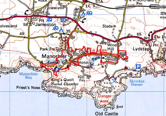
GRID REFERENCE: SS 067979
AREA IN HECTARES: 52
Historic Background
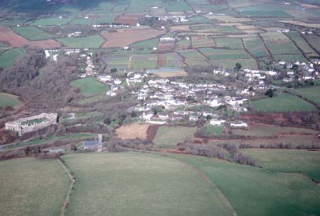
A small area of modern Pembrokeshire, comprising the built-up village of Manorbier. During the medieval period, it lay at the head of the Anglo-Norman manor of Manorbier (and Penally) which was a mesne lordship or honorial barony held, by the service of 5 knights, of the Lordship and Earldom of Pembroke, a heavily Anglicised region that was brought under Anglo-Norman control before 1100, re-organised along English manorial lines and never retaken by the Welsh. The barony had been held, since the very early 12th century, by the de Barris and, on their extinction in 1392, was sold to the Dukes of Exeter before reverting to the crown in 1461. From that point onwards it was leased to a succession of individuals before being settled on the Philippses of Picton Castle, with whom it remained until the 20th century. Manorbier is dominated by its castle, which may have been the site of a pre-Norman aristocratic centre or llys, which itself may overlie an iron age fort. Its separation from the parish church, which lies on the opposite side of a silted inlet, and indeed the distance between the church and the settlement, argue for early medieval origins for both, perhaps as a ‘paired’ secular/ecclesiastical site seen elsewhere in southwest Wales. There is some uncertainty as to whether the Manor of Manorbier gave its name to, or derived its name from, a pre-existing Welsh cwmwd of Maenor Pyr, but it has been argued that the ‘manor’ element is not derived from the Anglo-Norman ‘manor’ but from a pre-Conquest ‘maenol’ element linked to the ?personal name ‘Pyr’ also commemorated in the Welsh name for Caldey Island, ‘Ynys Pyr’. It also has been suggested that it formed part of a multiple estate – however, pre Anglo-Norman Conquest sources do not mention the settlement. The earliest recorded history is represented by the establishment of the castle, in c.1100. The de Barris lavished considerable sums on its development. It has 12th century masonry buildings, which are rare in Pembrokeshire. It is noted as being the birthplace, in 1146, of the churchman and chronicler Gerald de Barri – or ‘Giraldus Cambrensis’ – who provides an invaluable insight into the nature of the late 12th century manor, and its Anglo-Norman arrangements – ‘(the castle has) excellently well defended turrets and bulwarks, and is situated on the summit of a hill extending on the western side towards the seaport, having on the northern and southern sides a fine fish-pond under its walls, as conspicuous for its grand appearance, as for the depth of its waters, and a beautiful orchard on the same side, enclosed on one part by a vineyard, and on the other by a wood, remarkable for the projection of its rocks, and the height of its hazel trees. On the right hand of the promontory, between the castle and the church, near the site of a very large lake and mill, a rivulet of never-failing water flows through a valley, rendered sandy by the violence of the winds. Towards the west, the Severn sea, bending its course to Ireland, enters a hollow bay at some distance from the castle; and the southern rocks, extended a little further north, would render it a most excellent harbour for shipping... This country is well supplied with corn, sea-fish, and imported wines; and what is preferable to every other advantage, from its vicinity to Ireland, it is tempered by a salubrious air...’. The castle had become ruinous by the early 17th century but was refortified during the Civil War when it was taken, without resistance, by Parliament. After a period of slow decay it was partially restored in the late 19th century. The church, also mentioned by Giraldus, was granted to the Benedictines of Monkton Priory, Pembroke, in 1301. The park belonging to the castle lay to the west (mainly in East Moor and West Moor character area) and represented part of the manorial demesne; in the early 17th century it was described as enclosed by a stone wall and containing 60-70 acres of pasture. The development of a medieval settlement at the castle gate appears to have been unplanned, and piecemeal. An agricultural vill, the settlement was probably never very large and probably restricted to development along the roadside east of the castle; it is not mentioned in contemporary accounts and appears to have possessed neither market nor fair. Giraldus’ ‘harbour’ was never exploited. Manorbier was recorded in some detail in three later surveys of the Manor of Manorbier, in 1601, 1609 and 1618. It represented one of the three divisions of the manor, with a reeve responsible for rent-collection, and from the late 17th century was the scene of the manorial courts. Although it was the largest settlement in the manor, there were only 22 dwellings comprising 8 substantial farms, 9 houses and 5 cottages. From the surveys it is clear that the process of enclosure of the surrounding fields had already begun by the early 17th century. Corn-production in the village hinterland is confirmed by the surveys, and there was a 56-acre increase in arable between 1609 and 1618. There were by this time no game or deer in the park, which had been divided into three enclosures. Much of the demesne had been lost (becoming censory holdings) although the surveys mention the Lord’s Meadow, and the mill. The dovecot, which was ‘old and decayed’ in 1582, is not mentioned in later surveys. Tenants held land by freehold, and by two forms of copyhold called ‘husbandry hold’ and ‘censory hold’, which appear to be relics of an earlier, feudal tenure. At Manorbier, one freehold tenant rendered payment in cash. Over the three surveys 17 husbandry tenants are recorded possessing substantial farmsteads, including a total of 6 barns, 5 haggards (corn hay barns) and 4 cowhouses. Husbandry tenants had harvest the hay in the lords meadow and carry it to the castle, after which they had right of pasture in the meadow; they also had to clean the mill leat and provide millstones. The 12 censory tenants had 4 barns, 3 haggards and 3 cowhouses. Three tenants possessed sheepcotes; the animals were presumably grazed on the unenclosed coastal strip. The village appears to have developed little – and may have contracted - by 1774-5 when a map of the ‘The Crofts’ estate shows it as a few dispersed houses. On the tithe map of c. 1840, the village is depicted as a few houses on a single street. There has been some 20th century development, most of it to the east of the village where a housing estate was erected to serve Manorbier Camp (see Manorbier Camp character area). The camp was originally established as a World War 2 anti-aircraft artillery school. Manorbier, and its beach and castle are a popular tourist destination.
Description and essential historic landscape components
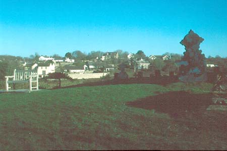
Manorbier is a relatively small, yet complex historic landscape character area containing many disparate components. It is essentially a developed area, and contains good examples of medieval buildings, church, castle and dovecote, as well a village of 19th century and later houses. It is centred on the medieval, masonry castle situated on an inland promontory at about 50m above sea level, but also includes steep-sided valleys, valley bottoms close to the sea, the medieval church on the opposite valley side, and modern housing on level ground inland from the castle. The castle, with its dominating high stonewalls, is set apart from the village at the end of a steep-sided promontory. Silted fish/mill ponds, a ruined mill, a medieval dovecote and a sewage works lie in the valley to the north of the castle. Car parks (for visitors to the beach) and rough ground lie in the valley to the south. A fine early 20th century stone-built village hall stands at the village core where three narrow streets meet. Other, old village buildings are 19th century in date, number only about 20 or 30 and are clustered in an unplanned fashion along these three streets. Cement rendered stone is the most common building material, under machine cut slate roofs. The unplanned character of the settlement is further reflected in the wide type and style of the buildings – there is little architectural coherence to the village. Houses vary from single storey, double fronted, vernacular cottages to two and three storey houses, a public house, a shop and small hotel in the polite ‘Georgian’ tradition. Some houses contain late 19th century period detail such as neo-gothic windows and door cases. Intermixed, and in an unplanned fashion, with the older structures are modern house and bungalows. Stonewalls flanking the narrow streets are a characteristic element of the village core. Ruined cottages close to St James’s Church with its tall medieval tower indicate a secondary village core, now reduced to a single dwelling. Larger scale planned development in the form of two mid-to-late 20th century housing estates lies on flat ground to the east of the historic village core. Piecemeal recent housing is beginning to infill the gaps between the village core and the housing estates. The unplanned nature of the village has resulted in many small open areas, such as the rough valley sides and valley bottoms. Sports fields are also present. Archaeological sites other than those mentioned above are not numerous and do not strongly characterise the area. They include prehistoric find spots and the site of a windmill.
This is a distinct area. It contrasts with the neighbouring areas of fields and farms.
Sources: Charles 1992; King and Perks 1970; Kissock 1993;
Ludlow 2000; Ludlow 2002; Manorbier Parish tithe map 1842; Milne 2001;
Pembrokeshire Record Office HDX/945/2; National Library of Wales NLW Vol
88; Owen 1892; Thomas 1994; Thorpe 1978; Walker 1992
Base map reproduced from the OS map with the permission
of Ordnance Survey on behalf of The Controller of Her Majesty's Stationery
Office, © Crown Copyright 2001.
All rights reserved. Unauthorised reproduction infringes Crown Copyright
and may lead to prosecution or civil proceedings. Licence Number: GD272221