Home > Historic Landscape Characterisation > Drefach-Felindre > |

 WAUNFAWR
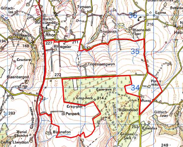
GRID REFERENCE: SN382339
AREA IN HECTARES: 475
Historic Background
This is a small area within modern Carmarthenshire, lying at the eastern end of an extensive ridge of high ground separating the Teifi valley to the north from the Tywi valley to the south. On Emmanuel Bowen’s map of 1729 it is shown as open moorland under the name ‘Mynydd Castell Newydd’. Historically, it presented a considerable barrier to travelers. The area was not enclosed until 1866. In common with similar landscapes elsewhere in southwest Wales prehistoric monuments represent the main historic landscape component. Two Bronze Age burial mounds are situtated at its highest point - both of which were intentionally highly visible - give visual character and time-depth to the area. No contemporary field systems have been recognised.
During the historic period, the bulk of this area lay within the medieval Cantref Emlyn, in Emlyn Uwch-Cych commote which remained largely in Welsh hands until the 13th century. It was finally annexed by the English crown in 1283, and in 1536 formed part of the Hundred of Elvet in Carmarthenshire. The southern part of this character area is in Cantref Gwarthaf, Elfed commote. This was brought under Anglo-Norman control soon after the establishment of the royal castle at Carmarthen, in 1109-10, as part of the associated ‘Honour of Carmarthen’. In 1284, it became the core of the newly-formed County of Carmarthen. However, it represented the ‘Welshry’ of the lordship and county, and so a Welsh tenurial pattern persisted in both areas - with neither vills nor knight’s fees . This is largely responsible for the dispersed settlement pattern throughout the region. Indeed little settlement appears to have occurred within the Waunfawr character area prior to the late 19th century. However, there is documentary evidence for lead and silver mining during the 16th and 17th centuries.
The eastern half of this character area belonged to a different landholding and tenurial regime, as part of Maenor Forion Grange. The grange was established during the second half of the 12th century, when the land was granted to the Cistercian Whitland Abbey by the sons of the local Welsh lord Maredudd of Cilrhedyn. We know little of the land-use within the grange - Maenor Forion is one of very few Welsh granges not to have be subject to an Exchequer Proceeding (Equity) after the Dissolution, from which much of our knowledge of grange management is derived. Most of Whitland’s estates were held, at the Dissolution, under various leases, tenurial systems, rents and obligations belonging to Welsh law. In general, the abbey’s Carmarthenshire properties paid money rents, and contributions of cheese, capons and oats. The survival a diversity of rents, in both cash, kind and service, suggests that they correspond with earlier villein obligations. It has been suggested that Whitland exploited its granges along native lines from the first, and therefore land-use and settlement were probably similar within and outside the boundaries of the grange, with this part of the grange probably always having been open grazing. The grange became crown land at the Dissolution in 1536 and this part of it appears to have been disposed of at an early date. There is documentary evidence for lead and silver mining within this general region during the 16th and 17th centuries.
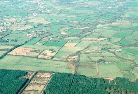
The entire character area was still open common land - essentially moorland – when the Llangeler tithe map was drawn up in 1839, although by this date its lower-lying fringes had been encroached upon by squatters, cottages built and fields established. Act of Parliament enclosed the greater portion of common, including most of this historic landscape character area, in 1866. Regular, relatively large fields were laid out, and soon after farms and cottages built. Since World War 2 a substantial coniferous forestry plantation has been established over part of the landscape; this has been excluded from this area.
Description and essential historic landscape components
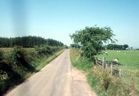
Waunfawr is the eastern end of an east-west aligned ridge forming the watershed between the Afon Teifi to the north and the Afon Tywi to the south. It lies between 210m and 310m above sea level. It is an agricultural landscape. The large regular fields and straight lanes are typical of a landscape created by Act of Parliament, in this instance in 1866. It is exposed and windswept, and consequently hedges on the earth-and-stone boundary banks are either straggling lines of low bushes, or non-existent. Post-and-wire fences are the chief stock-proof barriers. The area is treeless, apart from small shelter-belts around dwellings. Agricultural land-use is improved pasture, with occasional fields of unimproved grazing. Farms are small and widely dispersed, but buildings are not a prominent characteristic of this area. Late 19th century stone-built farmhouses in the typical southwest Wales style – two storey and three-bay with a central front door and five symmetrically arranged windows- are present, as are 20th century houses. Some 19th century small, stone-built agricultural outbuildings are present, as are small ranges of recent buildings. There are no listed buildings. There are few archaeological sites, but of note are Bronze Age round barrows on the two highest points.
This is a relatively well-defined historic landscape character area. It approximately corresponds to the land enclosed by Act of Parliament in 1866, minus a substantial forestry plantation.
Sources: Bowen E, 1729 A Map of South Wales; Cadw
– database of Building of Special Architectural or Historic Interest;
Cal. Patent Rolls, Elizabeth Vol. 2, 1560-1563, London 1948; Jones, A,
1937, ‘The Estates of the Welsh Abbeys at the Dissolution’,
Archaeologia Cambrensis 92, 269-286; Jones, D E, 1899, Hanes Plwyfi Llangeler
a Phenboyr, Llandysul; Jones, E G, 1939, Exchequer Proceedings (Equity)
concerning Wales, Cardiff; Lewis, S, 1833, A Topographical Dictionary
of Wales 1 & 2, London; Llangeler parish tithe map 1839; Lloyd, J
E, 1935, A History of Carmarthenshire, Volume I, Cardiff; Ludlow, N D,
forthcoming, ‘Whitland Abbey’, Archaeologia Cambrensis; National
Library of Wales Ms Vol 84 (PE965) Plan of Llangeler, Penboyr and Kilrhedin
Inclosure 1866; Rees, W, 1932, ‘Map of South Wales and the Border
in the XIVth century’; Rees, W, 1951, An Historical Atlas of Wales,
London; Regional Historic Environment Record housed with Dyfed Archaeological Trust;
Richard, A J, 1935, ‘Castles, Boroughs and Religious Houses’,
in J E Lloyd, A History of Carmarthenshire Volume I, 269-371, Cardiff;
Williams, D H, 1990, Atlas of Cistercian Lands in Wales, Cardiff
Base map reproduced from the OS map with the permission
of Ordnance Survey on behalf of The Controller of Her Majesty's Stationery
Office, © Crown Copyright 2001.
All rights reserved. Unauthorised reproduction infringes Crown Copyright
and may lead to prosecution or civil proceedings. Licence Number: GD272221