Home > Historic Landscape Characterisation > Drefach-Felindre > |

 AFON TEIFI: NEWCASTLE EMLYN - LLANDYSUL
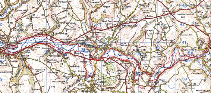
GRID REFERENCE: SN352401
AREA IN HECTARES: 388
Historic Background
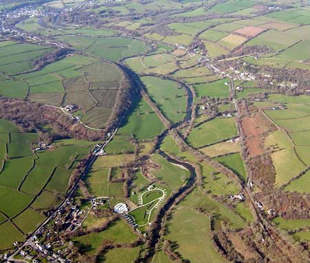
A long, narrow area within modern Carmarthenshire and Ceredigion, comprising the rich, scenic floodplain of the lower Afon Teifi between Newcastle Emlyn to the west and Llandysul, to the east. It is almost entirely farmland, consisting of fairly large, often regular fields of pasture. The Teifi forms the boundary between the two counties but the medieval and later history of the area is similar in both. Both Cantref Emlyn (Emlyn Uwch-Cych commote) south of the river, and Cantref Is Aeron (Gwynionydd commote) north of the river remained in Welsh hands until the 13th century, with a brief period of Anglo-Norman control - and the establishment of numerous castles - between 1100 and 1136. The English crown finally annexed both areas in 1283, when the county of Cardiganshire was created; In 1536, Emlyn Uwch-Cych eventually formed part of the Hundred of Elvet in Carmarthenshire. Welsh tenurial pattern - with neither vills nor knight’s fees - has been largely responsible for the dispersed settlement pattern within the region; this, and periodical flooding, have militated against major settlement within the area. However, some has occurred. The church at Llandyfrïog (Ceredigion), right on the riverbank, was already a parish church in 1291 and may have earlier origins (but was entirely rebuilt in the 19th century). It appears never to have been a focus for domestic settlement. The moated site at Henllys had been recorded by the 14th century (the name does not necessarily indicate particularly early origins), and a small number of farms - Ddôl, Berthyfedwen, Cwmisdwr and Bercoed Uchaf - were later established on the floodplain. The area would also have been more isolated than today during the historic period, as the two roads that now flank the floodplain - the A484 on the south side and the A475 to the north - are both former turnpike roads that were newly constructed in the late 18th century. The field pattern may have been largely established by the earlier post-medieval period, and estate maps and tithe maps show that this area has changed very little over the past 200 years. There has been a little loss of boundaries since estate maps were surveyed in 1778, and its clear from historic maps that in some areas the course of the river has changed. However, the construction of the ‘Carmarthen-Cardigan’ railway line through the area - opened under the Great Western Railway in 1895, but actually terminating at Newcastle Emlyn – once greatly contributed to the character of the area until it was closed in 1973. Its traffic was mainly locally produced textiles, with livestock, milk and timber.
Description and essential historic landscape components
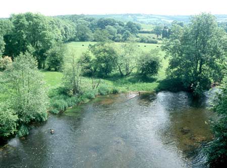
This area consists entirely of the floodplain of the Afon Teifi between Newcastle Emlyn and Llandysul, a distance of approximately 12km. The average width of the floodplain is about 0.5km and it lies between 30m and 50m above sea level. Land-use is almost entirely improved pasture with a little unimproved pasture. Fields are medium- to large-size, fairly regular and separated by hedges. The hedges are rarely set on boundary banks, and the banks that are present are low. Hedges sometimes flank streams or drainage ditches. Many of the hedges are overgrown and this together with the numerous large hedgerow trees and occasional isolated standard, lends a ‘parkland’ aspect to parts of the landscape. Apart from Llandyfrïog church, there are no buildings, but two bridges cross the river where the valley narrows to c. 50m wide. Pont Henllan is an 18th century single arch bridge of Teifi valley slate with a date stone of 1774, and Allt-y-Cafan Bridge is also built of local stone with a single arch and a date stone of 1839. Both are listed buildings. Former turnpike roads – the A484, A486 and A475 - run along the edge of the floodplain for part of their courses, and in places cross it. Mortared walls flank these roads for short sections. The heavily wooded embankment of a dismantled railway that runs almost the entire length of the floodplain is a distinctive landscape element. A sports field, sewage works and caravan site have recently been established on the floodplain. Known archaeology is limited to Henllys medieval moated settlement.
The few built structures and the ‘parkland’ aspect of the historic landscape character area set it out from its neighbours. Its level nature, as opposed to the hilly land of the surrounding landscape, enables a hard-edge boundary to be drawn around it.
Sources: Gwili Railway, n.d., Guide to the Gwili Railway; Lewis, S,
1833, A Topographical Dictionary of Wales 1 & 2, London; Llandyfrïog
parish tithe map1844; Llanfair Onllwyn parish tithe map 1844; Llangeler
parish tithe map 1839; Lloyd, J E, 1935, A History of Carmarthenshire,
Volume I, Cardiff; Ludlow, N, 2000 ‘The Cadw Welsh Historic Churches
Project: Ceredigion Churches’, unpublished Dyfed Archaeological Trust client
report; Meyrick, S R, 1810, The History and Antiquities of Cardiganshire,
London; National Library of Wales Rev J C Davies map book 1793 –1815;
Penboyr parish tithe map 1840; Rees, W, 1932, ‘Map of South Wales
and the Border in the XIVth century’; Rees, W, 1951, An Historical
Atlas of Wales, London; Regional Historic Environment Record housed with
Dyfed Archaeological Trust
Base map reproduced from the OS map with the permission
of Ordnance Survey on behalf of The Controller of Her Majesty's Stationery
Office, © Crown Copyright 2001.
All rights reserved. Unauthorised reproduction infringes Crown Copyright
and may lead to prosecution or civil proceedings. Licence Number: GD272221