|

301 CARN LLUNDAIN - CAER YSGUBOR 
GRID REFERENCE: SM699234
AREA IN HECTARES: 152.1
Historic Background
An area of modern Pembrokeshire occupying the southwestern half of
Ramsey Island, off of the western tip of St David's Head. Administratively,
the island formed part of the medieval Cantref Pebidiog or 'Dewisland',
which was held directly by the Bishops of St David's, having represented
the core of the bishopric from 1082 when it was granted (or confirmed)
by Rhys ap Tewdwr, king of pre-Conquest Dyfed, to Bishop Sulien. However,
earlier evidence of settlement exists on the island, and this probably
dates back to the bronze age. A number of field systems have also been
noted in this character area. They are concentrated around the bronze
age round barrows on the slopes of Carn Llundain and Caer Ysgubor, comprising
low stone banks or lines of orthostats, and although there is a lack of
firm dating evidence the erosion of soil on the two peaks suggests that
the system may belong to the more favourable climatic conditions of the
early or middle Bronze Age. The island is laden with legends from its
past inhabitants, many of them supernatural and involving the fairies
Y Tylwyth Teg and Plant Rhys Dwfn; others tell of the sound of bells beneath
the sea. Historically, the island formed part of the parish of St David's
and contained two medieval chapel sites one of which - dedicated to St
David - lay within this character area. It has been suggested that the
relationship between the island and the monastery at St David's may be
analogous to that between Llancarfan and Flatholm in the Bristol Channel,
as an island retreat for the monastic community. During the post-Conquest
period, Ramsey was an important pilgrimage site. From 1115, when Bernard
was appointed Bishop of St David's, Anglo-Norman systems of feudal government
and ecclesiastical administration were introduced into Pebidiog, which
was conterminous with the later Hundred of Dewsland created in 1536. However,
adapted Welsh tenurial systems appear to have persisted. Ramsey became
a fairly productive part of the Bishop's lands, and an Inquisition Post
Mortem of 1293 indicates that the island was fertile and that a wide range
of mixed farming was practised. Beef cattle, sheep and goats, and also
wheat, oats and barley are recorded. A more detailed account in the Black
Book of St David's of 1326, records that the bishop had 2 carucates of
land on the island, containing 100 acres, on which could be kept 10 horses,
100 head of 'great cattle' and 300 sheep. One hundred loads of rushes
and heath were taken per annum, and 500 rabbits 'for cooking' worth 33s
4d. The island was also exploited for gull, guillemot and puffin eggs.
Farming continued well into the 20th century, and in the 1900s was undertaken
by the Arnold brothers who grew barley, potatoes, turnips and peas, rearing
sheep and some pigs and horses. A corn mill and lime kiln were then both
still operational. Deep ploughing took place over the southern part of
the island from the 1930s to the 1950s. The island remained an ecclesiastical
holding until sold into private hands in 1905. It is now owned and managed
by the RSPB.
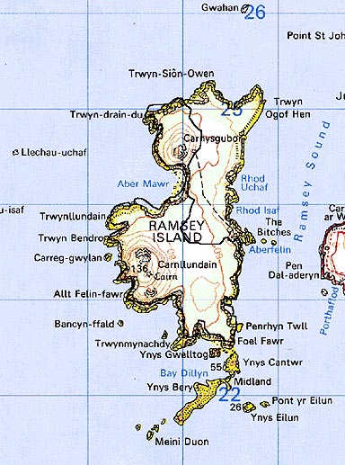
Base map reproduced from the OS map with the permission
of Ordnance Survey on behalf of The Controller of Her Majesty's Stationery
Office, © Crown Copyright 2001.
All rights reserved. Unauthorised reproduction infringes Crown Copyright
and may lead to prosecution or civil proceedings. Licence Number: GD272221
Description and essential historic landscape components
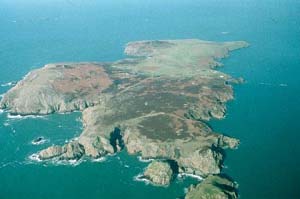
This historic landscape character area occupies the southern half and
western fringe of Ramsey Island. It is essentially unenclosed, and consists
of high sea cliffs and craggy slopes rising to a maximum of 136m on Carn
Llundain and 101m on Caer Ysgubor. Traces of a prehistoric field system
are visible as well as prehistoric cairns. The field system boundaries
take the form of low stony banks or lines of earth-fast boulders. The
northern part of the island is divided from this area by a stone-faced
bank. Land-use is rough moorland. It is a treeless landscape.
There are no settlements. There are no standing buildings within the area.
Recorded archaeology comprises a prehistoric findspot, two bronze age round barrows and two possible barrows, the field systems, a medieval 'David' dedication and possible cell.
Carn Llundain - Caer Ysgubor is a well defined historic landscape character area. To the west and south are high sea cliffs, and to the east the area is bounded by dry-stone walls of an actively used field system.
Sources: Fenton 1811; James 1981; James 1993; James and James 1994; Jones 1996; St David's tithe map and apportionment, 1840-41; National Library of Wales 14229/6 Map 84; Willis-Bund 1902