|

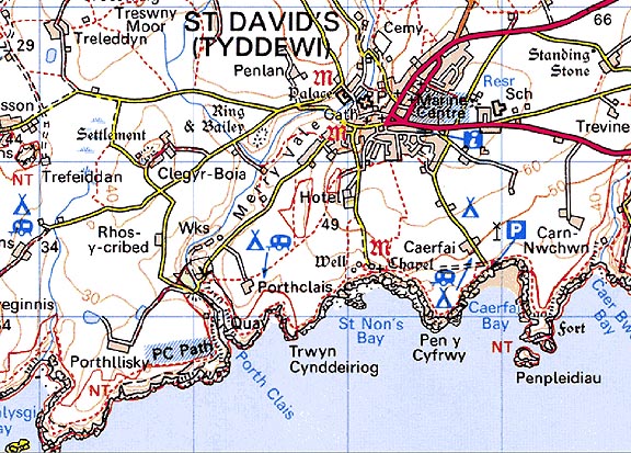
300 PORTH CLAIS 
GRID REFERENCE: SM740241
AREA IN HECTARES: 7.6
Historic Background
A natural harbour on the southern coast of the St David's peninsula, which
was the medieval and post medieval harbour of the borough of St David's.
It lay in the medieval Cantref Pebidiog, or 'Dewisland', which was held
directly by the Bishops of St David's, having represented the core of
the bishopric from 1082 when it was granted (or confirmed) by Rhys ap
Tewdwr, king of pre-Conquest Dyfed, to Bishop Sulien. The character area
lies within the historic parish of St David's, which even today preserves
a remarkable ecclesiastical topography. A medieval chapel and well site
at the head of the harbour, known as Capel-y-pistyll, may have early medieval
origins and had been fixed as the site of St David's baptism by the time
of Giraldus Cambrensis' writings in c.1200. From 1115, when Bernard was
appointed Bishop of St David's, Anglo-Norman systems of feudal government
and ecclesiastical administration were introduced into Pebidiog, which
was conterminous with the later Hundred of Dewsland created in 1536. During
the medieval period Porth Clais was chiefly used by the chapter of St
David's. The first record of trade from the port, and its quarries, is
found in a 1385 account of building works at the cathedral. The Welsh
Port Books for the years 1550-1603 record imports of luxury goods like
wine, raisins, pepper and calico, and timber from Ireland. The chief export
recorded is grain. References to trade and limeworking continue through
the 16th-, 17th- and 18th-century and it was said that every family in
St David's was involved in some aspect of maritime trade. Samuel Lewis
records that the quay had recently been extended in 1833, and that the
seven vessels which belonged to the port averaged 25 tons, chiefly plying
the Bristol route but also bringing limestone and culm from Milford Haven.
This trade continued into the late 19th-century but was increasingly threatened
by competition from road and rail, especially during the early 20th-century.
The coal trade struggled on, supplying both St David's and the gasworks
which had been established on the quayside during the 1880s, but this
ended in the 1930s and the coalyards and weighbridge were demolished.
Nevertheless, there are still the remains of four pairs of limekilns,
quarries and a number of other harbour structures at Port Clais.
Base map reproduced from the OS map with the permission
of Ordnance Survey on behalf of The Controller of Her Majesty's Stationery
Office, © Crown Copyright 2001.
All rights reserved. Unauthorised reproduction infringes Crown Copyright
and may lead to prosecution or civil proceedings. Licence Number: GD272221
Description and essential historic landscape components
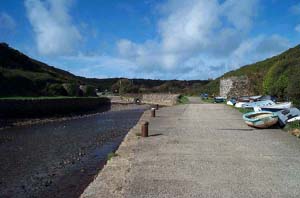
Porth Clais is a very small historic landscape character area. It comprises
a small harbour and associated structures. The harbour lies at the mouth
of the narrow, steep-sided valley of the River Alun. The only inhabited
structure comprises a modern bungalow, though there is evidence of deserted
dwellings close to the harbour. A stone-built break-water lies towards
low-water mark, with small stone-built quays on both sides of the valley
towards high-water mark. Banks of stone-built (restored) 19th century
limekilns are located on the quays. Small bridges cross the river immediately
upstream of the quays beyond which lie car parks to serve the tourist
industry and users of the harbour.
There six are listed buildings associated with the harbour. One each of the four pairs of limekilns are Grade II listed, as is the footbridge and Pen Porth Clais, a good example of a small two-storey Dewisland house. Other buildings/structures include the harbour itself (formerly listed), 2 quays, the remains of the gasworks, and a number of post-medieval buildings and building sites including 3 stores, and a cottage site.
Other recorded archaeology is confined to Capel-y-pistyll chapel and well sites, and two quarries.
This very small historic landscape character area consists of the harbour and associated structures. It contrasts sharply with neighbouring areas of fields and farms. Its boundaries are well defined.
Sources: James 1981; James 1993; Lewis 1833; Lewis 1927; St David's tithe map and apportionment, 1840-41