|

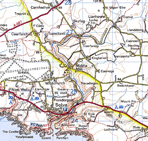
299 CAERFORIOG 
GRID REFERENCE: SM812265
AREA IN HECTARES: 128.6
Historic Background
An area of modern Pembrokeshire within St David's Peninsula. It lay in
the medieval Cantref Pebidiog, or 'Dewisland', which was held directly
by the Bishops of St David's, having represented the core of the bishopric
from 1082 when it was granted (or confirmed) by Rhys ap Tewdwr, king of
pre-Conquest Dyfed, to Bishop Sulien. The character area now lies within
Whitchurch parish but formerly lay within the historic parish of St David's,
which even today preserves a remarkable ecclesiastical topography. A medieval
chapel site at Caerforiog may have early medieval origins. From 1115,
when Bernard was appointed Bishop of St David's, Anglo-Norman systems
of feudal government and ecclesiastical administration were introduced
into Pebidiog, which was conterminous with the later Hundred of Dewsland
created in 1536. Welsh tenurial systems appear however to have persisted,
though variously adapted, in a version of Welsh custom in which an infield-outfield
system of open-field agriculture was practised. The land was held not
by an individual, but by two persons and their co-owners. Neither of the
two farmsteads within the character area, Caerforiog and Kingheriot, are
listed among the vills of Pebidiog in the Black Book of St David's of
1326. Caerforiog located in the centre of the character area is present
by 1341, but Kingheriot, on the edge of the area, is not recorded until
much later in 1543. Caerforiog is reputedly the birthplace of Adam de
Houghton, Bishop of St David's in 1361-89. The holding was later a possession
of the Perrot family. Nevertheless, that Caerforiog functioned as a vill
is demonstrated by the fact that it was associated with common land within
this character area, much of which features the large irregular enclosures
which are characteristic of late medieval - early post-medieval enclosure
of common land. The present field pattern is shown on the tithe map of
1840, but some of the fields, particularly those in the southern half
of the area, may represent the enclosure of former open-field strips,
are shown as slightly smaller, irregular fields.
Base map reproduced from the OS map with the permission
of Ordnance Survey on behalf of The Controller of Her Majesty's Stationery
Office, © Crown Copyright 2001.
All rights reserved. Unauthorised reproduction infringes Crown Copyright
and may lead to prosecution or civil proceedings. Licence Number: GD272221
Description and essential historic landscape components
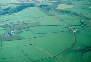
This relatively small historic landscape character area lies on a plateau
between approximately 50m and 65m. It is divided into large, irregular
fields by earth- and stone-banks. These are topped with low, windswept,
straggling lines of bushes. Wire fences supplement the banks and hedges.
Mortared-stone pillars (some replaced by concrete block) are used as gate
posts at field entrances. It is a treeless landscape. Land-use is improved
pasture and arable, with virtually no rough land. Farms are quite substantial,
and one in particular, Caerforiog, has a very extensive range of modern
agricultural buildings. Kingheriot is a good example of a two-storey stone-built
house in the Georgian tradition dating to c.1860 with a range of stone-built
farm buildings set around a courtyard to the front of the house. The house
is listed.
Recorded archaeology comprises a possible eolithic axe factory, the possible sites of two bronze age standing stone sites, an iron age or Roman findspot and a medieval chapel site.
Caerforiog historic landscape character area is difficult to define with any degree of confidence. It shares many characteristics with neighbouring areas, particularly those to the east and south which have yet to be defined. However, its large fields and open, treeless character do distinguish it as being different, though its boundaries must be considered open to redefinition, except to the west where it borders the wooded valley of Middle Mill historic landscape character area.
Sources: Charles 1992; Fenton 1811; James 1981; Jones 1996; Ludlow 1994; Whitechurch (St David's) tithe map and apportionment, 1840-41; Willis-Bund 1902