|

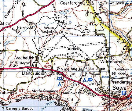
297 WAUN CAERFARCHELL 
GRID REFERENCE: SM781260
AREA IN HECTARES: 58.7
Historic Background
An area of modern Pembrokeshire on the south side of St David's Peninsula.
It lay within the medieval Cantref Pebidiog, or 'Dewisland', which was
held directly by the Bishops of St David's, having represented the core
of the bishopric from 1082 when it was granted (or confirmed) by Rhys
ap Tewdwr, king of pre-Conquest Dyfed, to Bishop Sulien. From 1115, when
Bernard was appointed Bishop of St David's, Anglo-Norman systems of feudal
government and ecclesiastical administration were introduced into Pebidiog,
which was conterminous with the later Hundred of Dewsland created in 1536.
This character area belonged to the 'manor' of Crughely, but Welsh tenurial
systems appear to have persisted, though variously adapted, and many feudal
rights and obligations continued even into the early 20th century. It
is the relict of a large unenclosed belt of informal waste or 'moor' (Waun)
that was divided between at least five medieval/post-medieval vills, each
of which had rights to a portion, the attribution of which survives in
the names Waun Vachelich, Waun Llandruidion, Waun Llechell, Waun Treflodan
and Waun Caerfarchell. The vill of Vachelich appears in the Black Book
of St David's of 1326, but Caerfarchell, Llandruidion and Treflodan do
not and may be 14th- or 15th-century in origin, while Llechell was not
mentioned until the mid 16th-century which may suggest a post-medieval
date for its origin, or at least for the division of the common. The tithe
map of 1840 shows the extent of the moor similar to the present day, but
also shows boundaries dividing the area into very large blocks. This may
have been an early 19th-century attempt by individual farmers to divide
the moor among themselves, rather than reflecting divisions according
to vills. A military airfield was established over much of the southern
part of this common (St David's Airfield character area) in 1943.
Base map reproduced from the OS map with the permission
of Ordnance Survey on behalf of The Controller of Her Majesty's Stationery
Office, © Crown Copyright 2001.
All rights reserved. Unauthorised reproduction infringes Crown Copyright
and may lead to prosecution or civil proceedings. Licence Number: GD272221
Description and essential historic landscape components
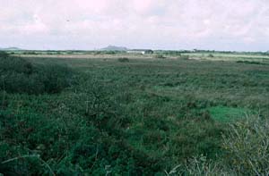
Waun Caerfarchell historic landscape character area lies along the floor
of an open valley at approximately 70m. It is essentially unenclosed,
wet common. Grazing is now limited and the whole is overgrown with scrubby
woodland on drier patches. At the western end Ordnance Survey maps show
the area divided into very large enclosures.
There are no settlements. There are no standing buildings within the area.
Recorded archaeology is limited to an enclosure of unknown nature. This is a well defined area with enclosed farmland lying to the west, north and east, and an old airfield to the south.
Sources: Charles 1992; James 1981; Whitechurch (St David's) tithe map and apportionment, 1840-41; Willis-Bund 1902