|

292 ST NONS - LLANDRUIDION 
GRID REFERENCE: SM769255
AREA IN HECTARES: 784.2
Historic Background
A large area of modern Pembrokeshire on the southern side of St David's
Peninsula. It lay within the medieval Cantref Pebidiog, or 'Dewisland',
which was held directly by the Bishops of St David's, having represented
the core of the bishopric from 1082 when it was granted (or confirmed)
by Rhys ap Tewdwr, king of pre-Conquest Dyfed, to Bishop Sulien. The character
area lies within the historic parish of St David's, which had a number
of subordinate chapels, and even today preserves a remarkable ecclesiastical
topography. Whitchurch, in the east of the area, did not become a parish
until the post-medieval period, originally being a chapelry of St David's.
A strong pre-Conquest ecclesiastical tradition is confirmed by the archaeology
of the area with a possible long-cist cemetery at St Non's, where the
late medieval chapel also includes an Early Christian Monument, and is
possibly the site of the chapel linked with mother of St David, mentioned
by Giraldus Cambrensis in the 12th century. In addition, there are a number
of llan place-name elements. Although many of these are later medieval
in origin, they indicate the locations of earlier chapels, probably devotional
sites rather than formal chapels-of-ease, while Llysgenydd may preserve
a llys place-name element. From 1115, when Bernard was appointed Bishop
of St David's, Anglo-Norman systems of feudal government and ecclesiastical
administration were introduced into Pebidiog, which was conterminous with
the later Hundred of Dewsland created in 1536. The major part of the character
area was divided between the 'manors' of Welsh Hundred with Tydwaldy,
Crughely, and Brawdy. However, Welsh tenurial systems appear to have persisted,
though variously adapted, and many feudal rights and obligations continued
even into the early 20th-century. Pebidiog was renowned for its fertile
arable land. According to the census in George Owen's Taylor's Cussion,
it was one of the most densely populated regions of Pembrokeshire in the
16th century, with the most plough teams, and was particularly productive
of barley. There were proportionately very few dairies. The Black Book
of St David's of 1326 gives some idea of the population density in an
earlier period, listing, among others, the vills Clegyr, Harngleu, Llanungar,
Porthlysgi, Trelerw, Trecenny and Vachelich; Llandruidion may be 15th
century in origin. All were semi-manorial, held by a version of Welsh
custom in which an infield-outfield system of open-field agriculture was
practised and the land was held not by an individual, but by two persons
and their co-owners. A relict of open-field farming survives near Trelerw
as a series of low ridges. 'Gavelkind' had only recently been abolished
in Pebidiog when Owen wrote in c.1600 that the land was still unenclosed
'and exposed to tempests'. 18th- and early 19th-century maps also show
much of the land still unenclosed, but by 1840, and the tithe survey,
the field system of today had been established. The medieval tenurial
system has given rise to the dominant settlement pattern of the area,
represented by a high density of small hamlets, mainly with Llan- and
Tre- place-names and largely based on the medieval vills. Vachelich and
the later Llandruidion were associated with a large, multiple area of
common to the north, the relict of which lies within Waun Caerfarchell
character area. Each hamlet is now occupied by a group of post-medieval
farm buildings. The economy of the area has remained overwhelmingly agricultural,
characterised since the mid 20th-century by early potato-growing, but
quarrying along the coast has been undertaken since the medieval period
when the fine-grained purple sandstone of Caer Bwdi was exploited for
St David's Cathedral and the Bishop's Palace. Many further quarries were
established along the coast during the post-medieval period, as well as
at least one limekiln. On the edge of the area lies St David's Airfield,
constructed during world war two. Also constructed at the same time was
a military camp at Caer Bwdi, and prisoner-of-war camp at Llandruidion.
Base map reproduced from the OS map with the permission
of Ordnance Survey on behalf of The Controller of Her Majesty's Stationery
Office, © Crown Copyright 2001.
All rights reserved. Unauthorised reproduction infringes Crown Copyright
and may lead to prosecution or civil proceedings. Licence Number: GD272221
Description and essential historic landscape components
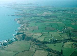
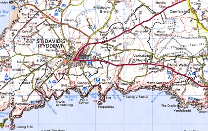
St Nons - Llandruidion historic landscape character area lies to the south
of St David's City almost as far east as Solva, with a small outlying
area to the west of Port Clais harbour. It includes a long stretch of
high coastal cliff and occasional sandy coves. The sea cliffs rise vertically
to approximately 30m at which point the land levels out to an undulating
plateau lying between 30m and 50m dissected by north-south aligned shallow
valleys. Apart from scrubby woodland in shelter afforded by the valleys
and a few trees close to habitations, this is a treeless landscape. Agricultural
land-use is dominated by improved pasture with a little arable land. Pasture
is generally rougher and has been subjected to less improvement close
to the coast, and the coastal strip outside the boundaries of cultivation
is rough ground not subjected to grazing. The Pembrokeshire Coast Path
runs along this strip. Overall the area is characterised by dispersed
farms and systems of small irregular fields. Field boundaries are almost
always banks of earth and stone, or of earth. Some examples are quite
substantial. Inland, low, straggling, windswept hedges top some banks,
but in more exposed locations close to the coast hedges are absent. Wire
fences supplement most of the boundary banks. 19th century, stone-built,
slate roofed dwellings of two-storeys and three bays, with examples in
both the vernacular tradition and the polite Georgian style, are the dominant
house type. Some have exposed stone others are cement rendered. In the
more exposed locations, some roofs have a cement skim over the slates.
In addition to the dispersed farms, small clusters of dwellings, the majority
of which are of 19th century date, are to be found at Trelerw and Llandruidion,
with a looser cluster of late 20th-century houses and bungalows at Whitchurch.
Other late 20th-century dwellings in a variety of styles and materials
are dispersed across the area, but do not form a significant element of
the settlement pattern. Old farm buildings are generally small, one or
two ranges, and stone-built with slate roofs, though there are one or
two examples of larger assemblages of buildings set around a courtyard.
Modern agricultural buildings of steel, concrete and asbestos likewise
tend to be relatively modest, though again with the occasional larger
complex. Within this area are a large set of modern buildings designed
to serve the potato industry. There are numerous camp sites and caravan
parks scattered across the area. Several old farm buildings have been
converted to serve these, and others have been converted to holiday accommodation.
Several old quarries lie along the coast, particularly at Caerfai Bay
and Caer Bwdi Bay, and most of the small coastal valleys contain the remains
of watermills and limekilns. This, however, is not an industrial landscape.
The remains of the world war two prisoner of war camp lie towards the
western boundary of this area. Transport links consist of the sweeping
course of the A487, the Haverfordwest - St David's - Fishguard road; a
former turnpike. Other roads and lanes are local-use, winding and flanked
by high banks.
There are 12 listed buildings in the area, including the medieval St Non's Chapel, which is Grade II listed, and St Non's Well, Grade II* listed. A ruinous, sub-medieval dwelling at Croftufty, with round chimney, is Grade II listed and has been partly excavated. The farmhouses at Clegyr Uchaf, Harglodd Isaf, Penberi, Penporthclais and Y Bwthyn, are all Grade II listed as is the 18th- to 19th-century house at Rhos-y-cribed, and an outbuilding. A limekiln to the southwest of the ruins of Caer Bwdi Mill is also Grade II listed. The 19th century pumphouse of Warpool Court, now a hotel in Warpool character area, is treated as a folly and Grade II listed, as is the contemporary ornamental garden. Pont Clegyr bridge (A487) may have early origins.
Recorded archaeology is very diverse, with a high percentage of prehistoric sites including 9 findspots, 6 of which are from the mesolithic period, one from the neolithic, and 2 from the iron age. There is a possible neolithic stone circle and possible chambered tomb, and a chambered tomb or standing stone. One bronze age standing stone is scheduled, and there are a further 5 possible standing stones, and 4 possible round barrows. An enclosure, a field system, and a clearance cairn may be prehistoric but are of unknown date. There are 2 scheduled iron age promontory forts of which Porth-y-rhaw has recently been excavated. The medieval St Non's Well and St Non's Chapel with inscribed stone have been described, and there are several other chapel and holy well sites, a hospice site and a possible cross site. Post-medieval sites include the earthwork remains of the post-medieval mill and ponds at Porth-y-rhaw, Caer Bwdi Mill and the scheduled quarry-working area, many other quarries, cottages and a cottage platform, a fold, and seven hut bases at Caer Bwdi world war two camp.
St Nons - Llandruidion historic landscape character area has reasonably well defined boundaries. To the south is the sea. Part of the northern boundary is formed by St David's City and its former open field system, though the boundary with the latter is not hard-edged but rather a zone of change. Other boundaries to the north, against unenclosed common and against a former airfield, are well established, but elsewhere where this area borders landscapes of fields and farms there is a zone of change not a definite boundary.
Sources: Charles 1992; Crane 1993; Crane forthcoming; Dicks 1968; Evans 1991; Fenton 1811; Fox 1937; Howell 1993; Howells 1971; Howells 1987; James 1981; James 1993; Jenkins n.d.; Lewis 1833; Pembrokeshire Record Office D/RTP/J H Harries 11/3; Pembrokshire Record Office D/RTP/J H Harries 6/67a; Pembrokshire Record Office D/RTP/J H Harries 6/68; Pembrokshire Record Office D/RTP/J H Harries 6/71; Pembrokshire Record Office D/RTP/Sto/183; National Library of Wales 14229/6 Maps 76, 78, 80, 81, 92; Rees 1932; Romilly Allen 1902; St David's tithe map and apportionment, 1840-41; Whitechurch (St David's) tithe map and apportionment, 1840-41; Willis-Bund 1902