|

290 PWLL TREFEIDDAN 
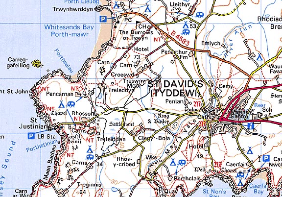
GRID REFERENCE: SM735253
AREA IN HECTARES: 39.7
Historic Background
A small area of unenclosed common in modern Pembrokeshire at the
southwest end of St David's Peninsula. It lay within the medieval Cantref
Pebidiog, or 'Dewisland', which was held directly by the Bishops of St
David's, having represented the core of the bishopric from 1082 when it
was granted (or confirmed) by Rhys ap Tewdwr, king of pre-Conquest Dyfed,
to Bishop Sulien. The character area lies within the parish of St David's.
From 1115 onwards, when Bernard was appointed Bishop of St David's, Anglo-Norman
systems of feudal government and ecclesiastical administration were introduced
into Pebidiog, which was conterminous with the later Hundred of Dewsland
created in 1536. However, Welsh tenurial systems appear to have persisted,
though variously adapted, and many feudal rights and obligations continued
even into the early 20th-century. Pebidiog was renowned for its fertile
arable land. Its high population density, and persistent Welsh tenurial
system, gave rise to the dominant settlement pattern of the area which
is represented by a high density of small hamlets, mainly with Tre- place-names,
largely based on the medieval vills. Each appears to have been associated
with two small separate areas of common land, one called 'common' and
one called 'moor', the latter being waste. The same association occurs,
on a larger scale, in the Pwll Trefeiddan character area, part of which
was the common and moor for the vill of Trefeiddan which was first recorded
in 1614 which may indicate that the system has post-medieval origins.
However, the area also includes Treswny Moor which, though first recorded
in 1650, may be derived from a rhos place-name element suggesting that
the common pre-dated the vill, indicating medieval origins for the system.
The character area also includes common associated with the vill of Rhosson.
The common land shown on the tithe map of 1840 occupies much the same
area as today, which may represent its original limit.
Base map reproduced from the OS map with the permission
of Ordnance Survey on behalf of The Controller of Her Majesty's Stationery
Office, © Crown Copyright 2001.
All rights reserved. Unauthorised reproduction infringes Crown Copyright
and may lead to prosecution or civil proceedings. Licence Number: GD272221
Description and essential historic landscape components
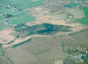
Pwll Trefeiddan historic landscape character area lies across the floor
of an open valley/linear hollow at about 35m. Apart from a small portion
of its northern length, it is surrounded by the fields and farms of Treleddyn
- Treginnis historic landscape character area. Though crossed by a lane,
it is unenclosed, and consists of wet moor and marsh with an extensive
tract of standing water and reed swamp - Pwll Trefeiddan. There are no
settlements. It is common land, but it is not now grazed. It is likely
that the peat of this area was cut to provide fuel. There are no standing
buildings within the area, and no recorded archaeological sites.
This area of wet common is a very distinct historic landscape and contrasts with the surrounding areas of farms and fields.
Sources: Charles 1992; Dicks 1968; Howell 1993; Howells 1971; Howells 1987; James 1981; St David's tithe map and apportionment, 1840-41; Willis-Bund 1902