|

289 TRELEDDYN - TREGINNIS 
GRID REFERENCE: SM730248
AREA IN HECTARES: 454.4
Historic Background
An area of modern Pembrokeshire at the southwest end of St David's
Peninsula. It lay within the medieval Cantref Pebidiog, or 'Dewisland',
which was held directly by the Bishops of St David's, having represented
the core of the bishopric from 1082 when it was granted (or confirmed)
by Rhys ap Tewdwr, king of pre-Conquest Dyfed, to Bishop Sulien. The character
area lies within the parish of St David's, which had a number of subordinate
chapels, and even today preserves a remarkable ecclesiastical topography.
However, there is evidence of an underlying, earlier landscape at the
southwest tip of the promontory with clearance cairns and a putative field
system, possibly from the bronze age. The early medieval significance
of the area is confirmed by the archaeology; the late medieval St Justinian's
Chapel has produced evidence of a probable early medieval cemetery, there
is a possible llys site at Henllys, while Clegyr-Boia appears to be named
from a 6th century chieftain. There may also have been a chapel at Porthlysgi
during the Middle Ages. From 1115, when Bernard, was appointed Bishop
of St David's, Anglo-Norman systems of feudal government and ecclesiastical
administration were introduced into Pebidiog, which was conterminous with
the later Hundred of Dewsland created in 1536. However, Welsh tenurial
systems appear to have persisted, though variously adapted, and many feudal
rights and obligations continued into the early 20th-century. Pebidiog
was renowned for its fertile arable land and was particularly productive
of barley, and had a high population density. The Black Book of St David's,
of 1326, lists among the vills of the 'manor' of Welsh Hundred, Treleddyn
(and 'Trefuergu' nearby) and, within the 'manor' of Crughely, the vill
at Castell Heinif. Not mentioned are Treginnis, which was first recorded
in 1335, Clegyr-Boia which was first recorded in 1472 and Rhosson, first
recorded in 1490 the latter two both associated with sub-medieval houses
- and Pencarnan first recorded in 1602. All were semi-manorial, held by
a version of Welsh custom in which an infield-outfield system was practised,
where land was held not by an individual, but by two persons and their
co-owners. In fact 'gavelkind' had only recently been abolished in Pebidiog
when Owen wrote in c.1600, that the land was still unenclosed 'and exposed
to tempests'. 18th- and early 19th-century maps show much of the land
still unenclosed. This tenure has given rise to the dominant settlement
pattern of the area, represented by a high density of small hamlets, mainly
with Tre- place-names and largely based on the medieval vills. Each hamlet
is now occupied by a group of post-medieval farm buildings. Each appears
to have been associated with two small separate areas of common land,
one called 'common' and one called Waun or 'moor', the latter being waste.
This may have origins within the medieval period but it is interesting
to note that Trefeiddan (Pwll Trefaiddan character area), which was not
recorded until 1614, shows the same double association of common land
so the system could be post-medieval in date. There is also common land
at St Justinian's. Treleddyn, Pencarnan and Trefeiddan are among the hamlets
shown as small nucleated settlements on two estate maps of 1762 and 1811,
surrounded by extensive tracts of unenclosed field systems, probably held
as 'shares' in a survival from Welsh tenure. The open field system is
very clear on the 1762 map, but by 1811 it had been partially enclosed
and transformed to a system of irregular, rectangular fields. The process
was complete by the tithe survey of 1840. The tithe map does, however,
show the last remnants of a sub-divided strip system at Clegyr-Boia, as
a few strips present in large enclosures, but elsewhere the present field
pattern was already in place. The economy of the area has remained overwhelmingly
agricultural, characterised since the mid 20th-century by early potato-growing,
but there is a post-medieval animal fold at Trefeiddan. In addition, many
quarries were established along the coast during the post-medieval period,
as well as at least one copper-mine which was operational during the first
few decades of the 19th century. A lifeboat station was established at
St Justinian's during the late 19th-century, an a look-out tower was constructed
- apparently by private enterprise - nearby. More recently there has been
an emphasis on tourism and leisure with the provision of a caravan park
at Pencarnan.
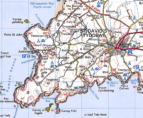
Base map reproduced from the OS map with the permission
of Ordnance Survey on behalf of The Controller of Her Majesty's Stationery
Office, © Crown Copyright 2001.
All rights reserved. Unauthorised reproduction infringes Crown Copyright
and may lead to prosecution or civil proceedings. Licence Number: GD272221
Description and essential historic landscape components
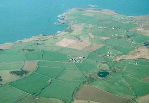
Treleddyn - Treginnis historic landscape character area occupies the extreme
southwestern point of the St David's peninsula. Sea cliffs border the
area to the west and south. These rise to about 30m, the land then levels
out to a gently undulating plateau lying between approximately 30m and
50m. Tor-like rock outcrops - monadnocks - which rise 10m to 20m out of
the plateau are a distinctive feature of the natural landscape. The historic
landscape is characterised by dispersed farms and fields. The field pattern
is of small irregular enclosures. Rubble banks, dry-stone walls, and earth
and stone banks comprise the main field boundary types. Hedges are absent
on the banks close to the exposed coastal fringe, and where present further
inland they consist of low straggling lines of windswept bushes and gorse.
It is a treeless landscape. Land-use is mainly improved pasture, with
some arable land. Rough grazing and scrubby land is mainly confined to
the rocky tors and the narrow coastal strip which lies between the limit
of enclosed land and the top of the sea cliffs. An unusual and distinctive
aspect of the settlement pattern is the location of farms in the lee of
the rocky tors, so affording some protection from the prevailing southwesterly
winds. These sheltered locations are often shared by more than one farm,
as at Rhosson and Clegyr-Boia, giving the impression of small agricultural
hamlets, rather than isolated, dispersed farms, though this pattern is
not so pronounced as that in the Treleddyd - Tretio - Caerfarchell historic
character area to the north and east. For such a relatively small historic
landscape character area, there is a great variety in the type of farmhouses,
ranging from a sub-medieval house complete with circular 'Flemish' chimney
at Rhosson through to an 18th century, two storey, double pile gentry
house at Treleddyn. Most houses are, however, of 19th century date, fairly
modest in size, two storey, three bay and generally in the vernacular
tradition, though there are examples in the more polite Georgian style.
20th century farmhouses and other dwellings in a variety of styles and
materials are present, but, apart from along some coastal sections, do
not form a strong element of the landscape. Old farm buildings are stone-built
and 19th century in date. Most consist of just one small range, though
larger assemblages exist at Rhosson and Treginnis Isaf. At the latter
site the buildings have been converted for accommodation. Modern agricultural
buildings in steel, concrete and asbestos sheet are relatively modest
in size and rarely overwhelm the older buildings. A small collection of
buildings at St Justinian's, including the ruined medieval chapel, lifeboat
stations and modern buildings, provide a tourist attraction. There are
several camp sites and caravan parks, most lying close to the coast. Local-use
roads and tracks are narrow and winding and enclosed by high banks.
There are 32 listed buildings in the area. Rhosson Uchaf farm, a classic example of the sub-medieval North Pembrokeshire house with a round chimney and lateral outshut, is Grade II* listed. Clegyr-Boia and Trefaiddan farmhouses were also similar examples of the sub-medieval North Pembrokeshire house. The wellhead at Rhosson Uchaf, and Waun Rhosson cottage, are also both Grade II listed, as are Rhosson-ganol and an outbuilding, and Rhosson Sunday School, built in 1864. Most of the remaining listed buildings are 18th-19th century. Treginnis Uchaf farmhouse, with a round chimney, and its range of outbuildings, are both Grade II listed. Eight buildings at Croeswdig, including the farmhouse and three ranges of outbuildings, are all Grade II listed, as are Treleddyn Isaf farmhouse and two ranges of outbuildings. The garden wall with built in crosshead at Treleddyn Uchaf is Grade II* listed, while one of the farm outbuildings is Grade II listed. Six buildings at Treginnis Isaf comprising the farmhouse, four ranges of outbuildings and the dovecote, are each Grade II listed. Plyg-y-tywyn at the northern edge of the area, on The Burrows, is a Grade II listed early 19th-century cottage. Both the lifeboat stations at St Justinian's, one from 1885 and the other from 1911, are Grade II listed, as is the early 20th century look-out tower
Recorded archaeology is fairly diverse. There have been mesolithic finds at St Justinian's and a flintworking floor at Porthlysgi, while there is a scheduled neolithic chambered tomb, and a neolithic settlement at Clegyr-Boia beneath the later iron age hillfort, also scheduled. From the bronze age are a findspot, clearance cairns and a possible field system, two possible standing stones and a possible round barrow. There is another scheduled iron age hillfort, and Roman finds on the shoreline. A place-name may record a possible llys site, while the scheduled and Grade I listed, later medieval chapel at St Justinian's is associated with early medieval and post-medieval findspots, an early medieval cemetery, and a scheduled and Grade II listed holy well. There is another holy well at Clegyr-Boia and a possible medieval chapel at Porthlysgi. There is a post-medieval fold at Trefeiddan, building platforms at Porthlysgi, and post-medieval quarries, a copper mine, and a possible mining feature on the coast.
Treleddyn - Treginnis historic landscape character area is defined to the west and south by sea cliffs. To the north there is good boundary definition against an area of former unenclosed wind-blown sand. It is only to the east that there is no hard-edged boundary but rather a zone of change. Here the neighbouring areas share many similar characteristics, but there are sufficient differences to warrant the division into separate historic landscape character areas.
Sources: Charles 1992; Dicks 1968; Fenton 1811; Fox 1937; Howell 1993; Howells 1971; Howells 1987; James 1981; James 1993; National Library of Wales Map 7574; Pembrokeshire Record Office HDX/1006; Romilly Allen 1902; St David's tithe map and apportionment, 1840-41; Williams 1953; Willis-Bund 1902