|

284 ROSEBUSH 
GRID REFERENCE: SN077298
AREA IN HECTARES: 42.3
Historic Background
A small area of modern Pembrokeshire, on the southern edge of Mynydd Preseli,
within the medieval Cantref Cemaes which was brought under Anglo-Norman
control in c.1100 by the Fitzmartins who retained it, as the Barony of
Cemaes, until 1326, when they were succeeded by the Audleys. The Barony
was conterminous with the later Hundred of Cemais, which was created in
1536, but many feudal rights and obligations persisted, some until as
late as 1922. The Rosebush character area belonged to the mesne lordship
(or manor) of Maenclochog, held from the Barony of Cemaes by the Roche
lords of Llangwm in the 13th- and 14th-century, when it was assessed at
one knight's fee. However, like most of the southeastern part of the Barony
within Mynydd Preseli, this area continued to be held under Welsh systems
of tenure. The entire area appears to have been open moorland pasture,
which may have been included in the grant of grazing rights for horses,
made by David de la Roche, Lord of Llangwm and Maenclochog, to Whitland
Abbey in 1301. Charles Hassall's record, in 1794, of the 'extensive waste'
persisting in Maenchlochog is reproduced in the County History, and the
character area remained unenclosed until 1815 when it was subject to a
Parliamentary Enclosure award, of which the present system of large regular
fields with straight boundaries is typical. The area was subsequently
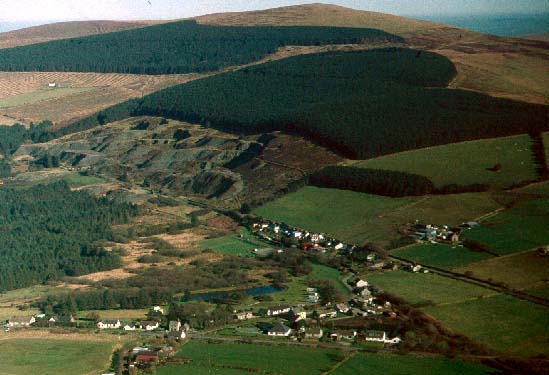
altered - in dramatic manner - by the Rosebush and Bellstone slate quarries;
the former being the only really large-scale operation in the area. Both
quarries commenced in c.1830 and were served by an existing route, the
present B4313, which may have had medieval origins. From c.1870 onwards
Rosebush expanded to employ well over 100 people, with an output of 5000
tons, and a village - with a chapel and hotel - developed at Rosebush.
The Maenclochog Railway was built to serve the quarries, opening in 1876,
and later extended to Fishguard. Attempts to establish Rosebush as a tourist
centre were, however, unsuccessful, and after the closure of the quarry
in 1908 it never expanded beyond a rural hamlet. The railway closed in
1949.
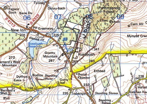
Base map reproduced from the OS map with the permission
of Ordnance Survey on behalf of The Controller of Her Majesty's Stationery
Office, © Crown Copyright 2001.
All rights reserved. Unauthorised reproduction infringes Crown Copyright
and may lead to prosecution or civil proceedings. Licence Number: GD272221
Description and essential historic landscape components
Large abandoned quarries and associated elements and structures are defining
characteristics of the Rosebush historic landscape character area. Parts
of the infrastructure established to serve these quarries survive and
include: a railway (abandoned), a railway hotel (Precelly Hotel), terraced
housing and other worker housing. The 19th century two storey stone-built
terrace of worker housing is a distinctive and unusual landscape feature
of the Mynydd Preseli landscape, as is the nearby two storey timber-framed
and corrugated-iron Precelly Hotel, built 1876-80, now a public house
and called Y Tafarn Sinc. Other houses at Rosebush are loosely clustered
and comprise one- and two- storey stone-built houses, mostly in the vernacular
style intermixed with which are late 20th-century houses and bungalows
in a variety of styles and materials. Capel Horeb is a 19th century Methodist
chapel. There are no listed buildings. A small caravan/camp site is situated
close to a small lake and parkland. Apart from the abandoned railway mentioned
above and the B4313 which crosses the western part of this area, transport
links are confined to lanes and tracks.
The recorded archaeology is confined to quarry features, including derelict buildings, spoil heaps, pits and inclines.
Rosebush is a distinctive historic landscape character area. It is an industrial landscape set amongst farmland and coniferous forestry plantations.
Sources: Dyfed Archaeological Trust 1997; Gale 1992; Howells 1987; Hunter 1852; Maenclochog tithe map and apportionment, 1841; Pembrokeshire Record Office MF 207; Rees 1932; Richards 1998