|

277 TREHAIDD 
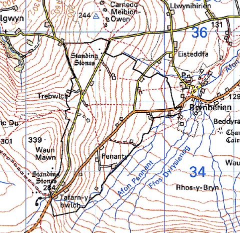
GRID REFERENCE: SN092346
AREA IN HECTARES: 247.6
Historic Background
A small area of modern Pembrokeshire, on the very northern edge of Mynydd
Preseli, within the medieval Cantref Cemaes. Cemaes was brought under
Anglo-Norman control in c.1100 by the Fitzmartins who retained it, as
the Barony of Cemaes, until 1326, when they were succeeded by the Audleys.
The Barony was conterminous with the later Hundred of Cemais, which was
created in 1536, but many feudal rights and obligations persisted, some
until as late as 1922. This character area lies within Nevern parish,
which was a borough of the barony during the medieval period. Its lies
on the northern edge of the great common of Mynydd Preseli, on which the
freeholders of Cemaes had been granted rights of pasture and turbary by
a charter of Nicholas Fitzmartin in the late 13th-century. Trehaidd was
in fact named as one of the boundaries of the common in the charter, when
it appears to have been an important landholding. Although Clyn-yr-wyn
was mentioned independently in a document of 1343, none of the other holdings
in this character area were listed in the Extent of Cemaes of 1577 which
suggests that the Trehaidd holding consisted of the entire area. Some
of the long, narrow fields within this area, which appear in form to be
of post-medieval enclosure type- the area is after all marked as 'Forest'
on Rees' map - may in fact be derived from enclosure of former field strips.
The establishment of the farmsteads of Trebwlch, first mentioned in 1671,
and Pen-y-lan fach, mentioned in 1715, may a result of later subdivision
of the larger holding of Trehaidd. The area has been crossed by the main
Haverfordwest-Cardigan route since the medieval period, and on its boundary
with the common lies Tafarn-y-bwlch, which must have already been an inn
in 1729 when it was marked, and labelled, on Emanuel Bowen's map. The
road was later turnpiked and is now the B4329. The remainder of the farms
were established in the 18th- and early 19th-century, and by the time
of the tithe survey of 1843 the area had taken on its present form.
Base map reproduced from the OS map with the permission
of Ordnance Survey on behalf of The Controller of Her Majesty's Stationery
Office, © Crown Copyright 2001.
All rights reserved. Unauthorised reproduction infringes Crown Copyright
and may lead to prosecution or civil proceedings. Licence Number: GD272221
Description and essential historic landscape components
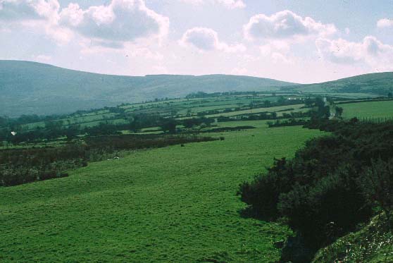
Trehaidd historic landscape character area lies on fairly gentle east-facing
slopes between 160m and 280m on the northern side of Mynydd Preseli. It
is characterised by dispersed settlements and by fields with a distinct
east-west trend. These fields are small- to medium-sized and generally
approximate to a rectangular shape. Field boundaries comprise earth banks
with a few earth and stone banks. Banks are topped with hedges, but except
for alongside roads and tracks and at a few locations at lower levels
these hedges are not well maintained and are either derelict or reduced
to straggling lines of bushes and small trees. These trees together with
little a scrubby woodland, particularly at lower levels, lend a wooded
aspect to parts of the landscape. Woodland is not, however a defining
characteristic. Wire fences provide the main stock-proof boundaries. Land-use
is almost entirely pasture with a little arable. Pasture is a mixture
of improved grazing, unimproved grazing and rougher, rushy land. The dispersed
settlements comprise farms and cottages. Dwellings are generally of 19th
century date in the vernacular style. One, one-and-a-half and two storey
buildings are present. They are stone-built (cement rendered and bare
stone), slate roofed and of three bays. 20th century dispersed housing
in a variety of styles and materials, from both early and later in the
century, is a feature of the buildings of this area. Farm outbuildings
where present are also quite small. Usually a single 19th century stone-built
range is present, sometimes in combination with a mid 20th-century corrugated-iron
structure and/or small late 20th-century steel, asbestos and concrete
buildings. Some of the larger farms have a collection of larger 20th century
agricultural buildings. There are no listed buildings within the character
area. Transport elements are confined to the B4239 and local-use lanes
and tracks. All are narrow and winding and bounded by hedge-banks.
Recorded archaeology comprises neolithic or bronze age finds, a scheduled bronze age stone pair, and a scheduled standing stone. There is also a scheduled Early Christian inscribed stone, and a holy well site.
Trehaidd is a distinctive and well defined historic landscape character area. It is bounded to the west, south and east by the open moorland of Mynydd Preseli. To the northwest and northeast lie the distinctive character areas of Cilgwyn and Brynberian-Miraniog, and to the north the open land of Carnedd Meibion Owen.
Sources: Bowen 1729; Charles 1992; Dyfed Archaeological Trust 1997; Howells 1977; Nevern tithe map and apportionment, 1843; Rees 1932