|

276 GOCHEL SYTHI 
GRID REFERENCE: SN059361
AREA IN HECTARES: 166.8
Historic Background
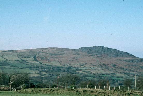
A small area of modern Pembrokeshire, on the southern side of Mynydd Carningli,
north of the Gwaun, within the medieval Cantref Cemaes. Cemaes was brought
under Anglo-Norman control in c.1100 by the Fitzmartins who retained it,
as the Barony of Cemaes, until 1326, when they were succeeded by the Audleys.
The Barony was conterminous with the later Hundred of Cemais, which was
created in 1536, but many feudal rights and obligations persisted, some
until as late as 1922. This character area lies within Newport parish,
which was a borough of the barony during the medieval period. It is possible
that the medium-sized irregular fields which lie in part of this area
were enclosed under the management of Dolrannog, which lies within Cilgwyn
character area immediately to the south. Dolrannog was mentioned in a
document of c.1280, and was assessed for 6d rent from Thomas Lloid in
an Extent of 1577. The larger, more regular enclosures that lie to the
north, west and east sides of this area probably represent later enclosure
of Carningli (a common of Newport borough) during the 18th- and early
19th-century at a time of rising population. They are associated with
now-abandoned farmsteads that are suggestive of squatter settlement or
tai-unnos, for instance Gochel Sythi ('Beware of freezing'). The settlements
are accompanied by small paddocks which exhibit traces of cultivation
ridges, but the area remained predominantly pastoral and contains three
sheepfolds - a high density for such a small number of farmsteads. The
tithe map of 1843 shows the field system with several farmsteads. Farmsteads
had been largely abandoned by the mid- to late- 19th-century, and the
fields at higher elevations are gradually reverting back to open moorland.
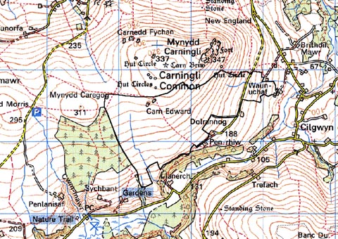
Base map reproduced from the OS map with the permission
of Ordnance Survey on behalf of The Controller of Her Majesty's Stationery
Office, © Crown Copyright 2001.
All rights reserved. Unauthorised reproduction infringes Crown Copyright
and may lead to prosecution or civil proceedings. Licence Number: GD272221
Description and essential historic landscape components
Gochel Sythi historic landscape character area lies on fairly steep southeast-facing
slopes between 180m and 300m on the southern side of Mynydd Carningli.
It is divided into small- to medium-sized irregular fields. Field boundaries
consist of earth and stone banks and stony banks. Straggling hedges lie
along the banks at lower levels, but on the higher ground hedges are absent
and the fields are reverting to open moorland. Wire fences provide stock-proof
boundaries. Land-use is a mixture of improved pasture (mostly at lower
levels) and unimproved pasture and rough grazing with rushy ground. The
land becomes increasingly less improved at higher altitude. There are
no inhabited buildings, though a distinctive feature of the landscape
are deserted farms surrounded by clumps of trees. Apart from these trees
and a few examples on overgrown hedges at lower levels, this area is not
characterised by woodland. Three sheepfolds are located in this area.
Transport elements are confined to a few lengths of track leading into
this area from the lower-lying land to the south.
Recorded archaeology comprises a probable round barrow, an unknown enclosure site and cultivation ridges etc. associated with the post-medieval farms.
This area is sandwiched between unenclosed moorland to the north and enclosed farmland and woodland to the south and east. A coniferous forestry plantation lies to the west.
Sources: Charles 1992; Dyfed Archaeological Trust 2000; Howells 1977; Newport tithe map and apportionment, 1843.