|

273 TREGYNON 
GRID REFERENCE: SN049340
AREA IN HECTARES: 511.0
Historic Background
An area of modern Pembrokeshire, on the western flanks of Mynydd Preseli,
within the medieval Cantref Cemaes. Cemaes was brought under Anglo-Norman
control in c.1100 by the Fitzmartins who retained it, as the Barony of
Cemaes, until 1326 when they were succeeded by the Audleys. The Barony
was conterminous with the later Hundred of Cemais, which was created in
1536, but many feudal rights and obligations persisted, some until as
late as 1922. Tregynon character area lies mainly within the hamlet of
Cilgwyn, Nevern parish, which was a borough of the barony during the medieval
period. The Extent of Cemaes, compiled in 1577, shows that most of the
holdings within the present character area had already been established.
Chief among them was Tregynon 'with its parcels', first mentioned in 1315,
which together paid 2s 3d annually to the Barony of Cemaes. Penrallt(ddu),
then held by James Perrott, paid 3d. This was a minor gentry house of
the Vaughan family, who were to acquire much land in the region by the
early 17th-century. 'Kilykenawon', which was assessed at 8d rent and the
site of a medieval chapel, is located on the Rees map within this character
area. The 'land at Kilgwyn of David Lloid', liable for 6d rent, may be
equated with the gentry-house at Trefach, which was the home of the Lloyd
family in the 17th- and 18th- century and assessed for 5 hearths in 1670.
These holdings may date from the 16th century; the pattern of medium-sized,
irregular fields is typical of enclosure of that period from land that
may formerly have been open pasture. However, some narrower enclosures
towards the south may preserve the pattern of earlier strips fields. The
tithe map of 1843 shows a situation like that of the present day. Land-use
is still predominantly pastoral, and there is a sheep-dip at Trefach.
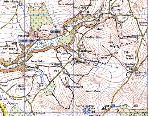
Base map reproduced from the OS map with the permission
of Ordnance Survey on behalf of The Controller of Her Majesty's Stationery
Office, © Crown Copyright 2001.
All rights reserved. Unauthorised reproduction infringes Crown Copyright
and may lead to prosecution or civil proceedings. Licence Number: GD272221
Description and essential historic landscape components
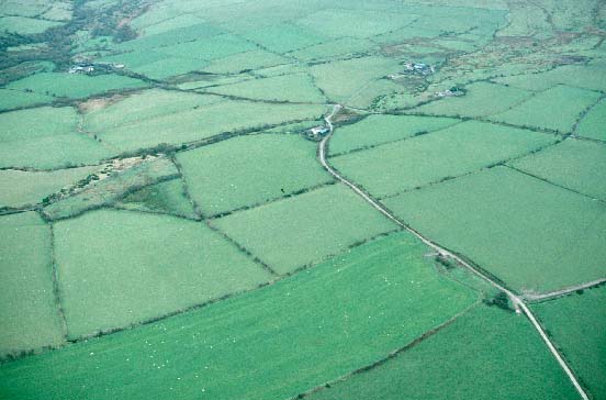
Tregynon historic landscape character area occupies a west- and northwest-facing
gently sloping shelf of land located at 170m and 320m sandwiched, between
the open moorland of Mynydd Preseli and the heavily wooded steep valley
sides of the Afon Gwaun. The landscape is divided into small- and medium-sized
fields. The smaller fields usually lie close to farmsteads. Field boundaries
consist of massive earth banks in the western part of the area through
to less substantial earth and stone banks at the eastern end and on higher
ground on the fringes of Mynydd Preseli. Apart from alongside lanes and
at the eastern end there are no hedges on the banks, and hedges where
they survive are generally not in good condition. It is a virtually treeless
landscape. Land-use is improved pasture with pockets of rougher grazing,
particularly in wet hollows. At higher levels some fields are beginning
to revert to moorland. Farms are widely dispersed across the landscape.
At higher levels several are deserted. Farmhouses are in a variety of
styles. The main type comprises a 19th century, two storey, three bay,
stone-built dwelling, with a slate roof, in the vernacular style. Single
storey 19th century dwellings in the vernacular style are also present,
as well as some 20th century farmhouses. Most farms have a single small,
stone-built 19th century range of farm buildings, with a mid 20th-century
corrugated-iron barn and other structures and several small late 20th-century
steel-, concrete- and asbestos-built structures. The larger farms have
several large 20th century agricultural buildings. Trefach House and mill
are both Grade II listed. Tregynon House is now a country hotel and restaurant.
Transport elements of this landscape consist of local-use lanes and tracks.
Recorded archaeology is fairly rich for such a small area, including two scheduled bronze age standing stones (one of which may be from a neolithic chambered tomb), and the scheduled iron age hillfort of Castell Tregynon. There is a possible Early Christian inscribed stone, while 'Kilykenawon' was the site of the medieval Capel Cynon. Post-medieval features include a well, a deserted rural settlement, and a sheep dip. There is a further earthwork of unknown nature.
This is a distinctive and generally well defined historic landscape area. The lower-lying heavily wooded landscape of Cilgwyn lies to the north, the heavily wooded slopes of Cwm Gwaun to the northwest and to the east lies the open moorland of Mynydd Preseli. Definition is less clear between this area and land to the west, and between this area and Gellifawr, which it virtually surrounds.
Sources: Charles 1992; Howells 1977; Jones 1996; Nevern tithe map and apportionment, 1843; Owen 1897; Rees 1932