|

271 MYNYDD-DU 
GRID REFERENCE: SN070306
AREA IN HECTARES: 211.4
Historic Background
A small area of modern Pembrokeshire, on the southern flanks of Mynydd
Preseli, within the medieval Cantref Cemaes. Cemaes was brought under
Anglo-Norman control in c.1100 by the Fitzmartins who retained it, as
the Barony of Cemaes, until 1326 when they were succeeded by the Audleys.
The Barony was conterminous with the later Hundred of Cemais, which was
created in 1536, but many feudal rights and obligations persisted, some
until until as late as 1922. During the medieval period, part of the Mynydd-du
character lay within the parish (and borough) of Nevern, but the greater
portion was part of the former manor of Redwalls. Redwalls is Pembrokeshire's
most prominent, and possibly most important, deserted medieval settlement,
the core of which lies at Fagwyr Goch just west of this character area.
It was first mentioned in 1293 when Robert de Vale, Lord of Dale in Pembrokeshire,
obtained from King Edward I a grant of a weekly market and a three day
annual fair 'for his manor of Redwalls'. The Vales had acquired the manor
from the Barony of Cemaes during the 13th century. Neither the date nor
the manner of this acquisition are known but its location, and the fact
that the manor was never assessed in terms of knight's fees, suggest that
it was a recent creation, a large-scale 13th century assart onto relatively
poor land, that ultimately 'failed'. The name 'Redwalls' is probably not
derived from the colour of its walls, as suggested by Charles, but a corruption
of Rudvall, a term given in Pembrokeshire to a form of local tenure by
which strip fields were amassed and grazed in common. During the 16th
century the manor was held by both 'English' tenure, two tenants paying
£3 rent each annually to the Barony of Cemaes, and 'Welsh' tenure, one
tenant paying 20s annually, as recorded in an Extent of the Barony compiled
in 1594. However, it appears also to have been in decline, with in total
only four tenements of demesne recorded in the manor along with gale tenants
and their obligations for reaping, and rights of herbage for cattle grazing
on the field strips. The pattern of small irregular fields in the southern
half of the character area probably derives from the early post-medieval
enclosure of such strips. The four tenements may be the same as the four
small farmsteads shown on the earliest large-scale maps of this area,
which date from the late 18th-century. On the same maps the pattern of
larger, more regular fields on the higher slopes to the north of the area
(extending into Banc Du character area) is derived from later 17th- and
18th-century enclosure of former common land, which belonged to the parish
and borough of Nevern. The field pattern has changed little since then,
except that some of the larger fields have been subdivided. The B4239
which runs through the area has medieval origins as the main Haverfordwest
to Cardigan route. A section of the Maenclochog Railway (later GWR) which
operated from 1876 until 1949 also crosses the southern edge of the area.
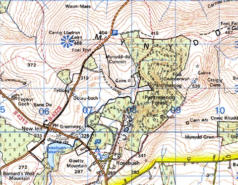
Base map reproduced from the OS map with the permission
of Ordnance Survey on behalf of The Controller of Her Majesty's Stationery
Office, © Crown Copyright 2001.
All rights reserved. Unauthorised reproduction infringes Crown Copyright
and may lead to prosecution or civil proceedings. Licence Number: GD272221
Description and essential historic landscape components
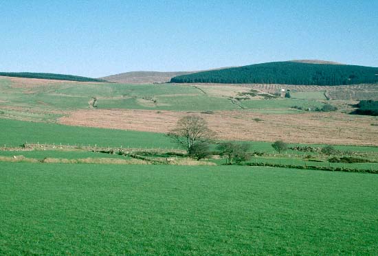
Mynydd-du historic landscape character area lies across the upper valley
of the Afon Syfni and its tributaries, on the southern slopes of Mynydd
Preseli between 240m and 370m. Farms and small, irregular fields are mainly
confined to sheltered lower valley sides. On the higher slopes the smaller
enclosures give way to larger, more regular fields. Boundaries to the
fields consist of earth- and earth and stone-banks. Apart from at the
lowest levels in the south of the area and alongside roads, hedges on
these banks are either reduced to a few bushes or have completely gone.
Wire fences on the banks provide stock-proof boundaries. Improved pasture
is the main land-use type mixed with a little rough grazing, but on the
valley floors there are extensive tracts of wet, rushy ground and peat
deposits. Included in this area is a small coniferous forestry plantation.
Deserted farms and cottages marked by small stands of trees are a characteristic
feature of this landscape. Trees provide shelter for extant farms. Apart
from these trees and the coniferous plantation, this area is not characterised
by woodland. It is essentially a treeless landscape, and the absence of
hedges lends a very open, unenclosed aspect to the area. Most farmhouses
are two storey, stone-built, three bay, slate roofed in the 19th century
vernacular tradition. 19th century farm out-buildings are stone-built,
with one or two ranges present. Most farms also have mid 20th-century
corrugated-iron buildings and small ranges of later 20th-century steel
and concrete structures. There are no listed buildings in the area. Transport
elements of the landscape comprise an abandoned railway and the B4329
road.
Recorded archaeology is limited to a post-medieval mill site and the railway.
To the east Mynydd-du historic landscape character area is bordered by a forestry plantation and is therefore well defined. To the north and west definition is also good against the open land of Mynydd Preseli and the semi open land of Banc Du. Only to the south where this area borders enclosed farmland is there no hard-edged boundary, but rather a zone of transition.
Sources: Cal. Charter Rolls 2; Charles 1992; Henry's Moat tithe map and apportionment, 1840; Howells 1977; Morvil tithe map and apportionment, 1839; Owen 1892; Owen 1897; Pembrokeshire Record Office D/RKL/932; Rees 1932