|

270 PANT MAENOG 
GRID REFERENCE: SN081308
AREA IN HECTARES: 308.3
Historic Background
An area of modern Pembrokeshire, on the southern flanks of Mynydd
Preseli, within the medieval Cantref Cemaes. Cemaes was brought under
Anglo-Norman control in c.1100 by the Fitzmartins who retained it, as
the Barony of Cemaes, until 1326 when they were succeeded by the Audleys.
The Barony was conterminous with the later Hundred of Cemais, which was
created in 1536, but many feudal rights and obligations persisted, some
as late as 1922. The Pant Maenog character area belonged to the mesne
lordship or manor of Maenclochog, held from the Barony of Cemaes by the
Roche lords of Llangwm in the 13th- and 14th-century, when it was assessed
at one knight's fee. In 1594, Maenclochog was - like other Cemaes manors
- held on an annual lease from the Barony, this one being assessed in
an Extent at 3s 8d. However, like most of the southeastern part of the
Barony, within Mynydd Preseli, this area continued to be held under Welsh
systems of tenure. During the medieval period the area was unenclosed
moorland which may have been included in the grant to Whitland Abbey,
of grazing rights for horses 'on Preseli and the waste places thereabouts
for seven years, at one penny and thereafter 2 shillings', made by David
de la Roche, Lord of Llangwm and Maenclochog, in 1301. It appears to have
remained unenclosed, and for the most part unsettled, until the 19th century.
Charles Hassall's record, in 1794, of the 'extensive waste' persisting
in Maenchlochog is reproduced in the County History. However, some squatting
is suggested by a series of small enclosures towards the north of the
area, and by two isolated former farmsteads. Much of the southern part
of the area was enclosed within very large, regular fields in 1815 when
it was subject to a Parliamentary Inclosure Award, but all farms and cottages
within this area, including those established following Parliamentary
enclosure, were subsequently abandoned and later planted with coniferous
forestry. This took place in the second half of the 20th century. It post-dates
the closure, in 1908, of the Bellstone slate quarry at the southern end
of the area which commenced production in c.1830 and peaked in 1870-1900,
elements of which also lie beneath the forestry.
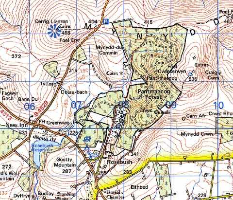
Base map reproduced from the OS map with the permission
of Ordnance Survey on behalf of The Controller of Her Majesty's Stationery
Office, © Crown Copyright 2001.
All rights reserved. Unauthorised reproduction infringes Crown Copyright
and may lead to prosecution or civil proceedings. Licence Number: GD272221
Description and essential historic landscape components
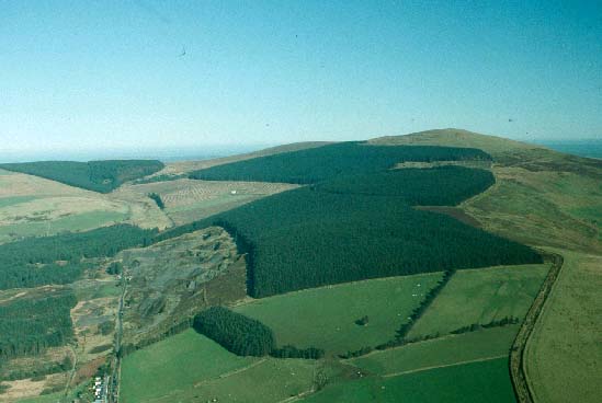
Pant Maenog is a large coniferous forestry plantation lying on the south
and southwest flanks of Mynydd Preseli between 250m and 490m. No detailed
ground examination of this area was undertaken, and therefore it is uncertain
to what extent former boundary banks and other pre-afforestation landscape
elements survive beneath the dense covering of trees. Sections of the
plantation on its western side have been clear-felled. The major historic
landscape features of this area now comprise the plantation and its associated
elements such as the extraction roads and tracks. There are no inhabited
settlements in this area.
Recorded archaeology is limited to two scheduled bronze age round barrows, a windmill site, of unknown age, shown on 19th century maps, and some late 19th-century quarry features from Bellstone.
Pant Maenog coniferous plantation historic landscape character area is bordered by the open moorland of Mynydd Preseli or lower-lying enclosed farmland of Mynydd Bach and Mynydd-du. It is therefore a characteristically distinct and well defined area.
Sources: Howells 1977; Hunter 1852; Maenclochog tithe map and apportionment, 1841; Pembrokeshire Record Office MF 207; Pembrokshire Record Office HDX/1524/8; Rees 1932; Richards 1998.