|

266 LLANGOLMAN 
GRID REFERENCE: SN125264
AREA IN HECTARES: 1461
Historic Background
A large character area on the southern edge of Mynydd Preseli. The
majority of it is in modern Pembrokeshire, within the medieval Cantref
Cemaes. That the character area was a centre of ecclesiastical significance
during the early medieval period is demonstrated by the establishment
of one of the seven pre-Conquest 'bishop-houses' of Dyfed at Llandeilo
Llwydarth, mentioned in the 12th century Liber Landavensis. Two Early
Christian Monuments from the church are now in Maenclochog Church. Cemaes
was brought under Anglo-Norman control by the Fitzmartins in c.1100. The
Fitzmartins retained it, as the Barony of Cemaes, until 1326 when they
were succeeded by the Audleys. The Barony was conterminous with the later
Hundred of Cemais, which was created in 1536, but many feudal rights and
obligations persisted, some until as late as 1922. Most of the Llangolman
character area belonged to the mesne lordship or manor of Maenclochog,
held from the Barony of Cemaes by the Roche lords of Llangwm in the 13th-
and 14th-century when it was assessed at one knight's fee. By 1594, Maenclochog
had its own court leat and was - like other Cemaes manors - held on an
annual lease from the Barony, this one being assessed in an Extent at
3s 8d. However, like most of the southeastern part of the Barony, within
Mynydd Preseli, this area continued to be held under Welsh systems of
tenure. The ecclesiastical framework was nevertheless reorganised upon
Anglo-Norman lines and Llandeilo Llwydarth along with the chapel at Llangolman
to the east were annexed to the vicarage of Maenclochog, which in turn
was granted to St Dogmael's Abbey by David de la Roche in c.1320. At the
far east end of the area is the parish church of Mynachlog-ddu which was
part of a much earlier grant to St Dogmaels, in 1118, as part of the grange
of Nigra Grangia granted by William Fitzmartin, and which was, after the
Dissolution, held distinct from the Barony of Cemaes. The grange chapel
of 'St Julians' or 'St Giles' (ded. St Silin) may also have occupied the
area. By the late 15th-century, considerable lands within the Llangolman
character area had been amassed from the manor of Maenclochog by a local
yeoman family, the Llywelyns, but in 1498 they granted 'all their lands
in Llangolman and at Bwlch-y-clawdd (Temple Druid) in Maenclochog', which
were held by Welsh tenure, to Lewis ap David ap Gruffudd Fychan of Llangolman,
yeoman, 'on account of great necessity and poverty'. The pattern of dispersed
settlement is typical of native tenurial systems, and the vill recorded
at Llandeilo Llwydarth appears never to have become a nucleation, while
the pattern of enclosure with regular fields of medium size is characteristic
of 16th- 17th-century enclosure, under farmsteads such as Pencraig-fawr
and Plas-cwrt which were recorded in the 16th century, while a deer park
at 'Loydarth' was also recorded in the later medieval period. The process
of enclosure was complete by the late 18th-century. However, though the
Ty Mawr estate map of 1777 shows most of the holding as today, a few unenclosed
dispersed strips within other farms holdings are also shown, suggesting
that this landscape had evolved out of a system of sub-divided strip-fields,
in this case probably lleini held under Welsh tenure. Other 18th century
gentry houses existed at Plas-y-Meibion, and Temple Druid which was rebuilt
by John Nash. A small part of the character area to the southeast lies
in Carmarthenshire, and in the middle ages belonged to Llwyn-yr-ebol,
a grange of Whitland Abbey which was granted to the Cistercians by Maelgwn
ap Rhys, son of Rhys ap Gruffudd, between 1197 and 1231. It is likely
that it represents early enclosure of monastic common pasture, probably
again from the 16th- and 17th-century. The history of the character area
was and still is dominated by agriculture, although it contains Pembrokeshire's
densest concentration of slate quarries. A total of 13 named quarries,
and several more informal workings, are more-or-less strung out in an
east-west line across the volcanic ash slate exposure through the centre
of the area. Most of these were rather late, being established from the
mid 19th-century onwards. All are now disused but the largest of them
- for instance, Dandderwen ('Whitland Abbey Slate') and Lily - occupied
a considerable area and brought employment to many hundreds. An additional
element is the early Baptist chapel at Rhydwilym, which was founded in
1668 under the benefaction of local gentry families and had, from the
first, an exceptional influence over a wide area.
Base map reproduced from the OS map with the permission
of Ordnance Survey on behalf of The Controller of Her Majesty's Stationery
Office, © Crown Copyright 2001.
All rights reserved. Unauthorised reproduction infringes Crown Copyright
and may lead to prosecution or civil proceedings. Licence Number: GD272221
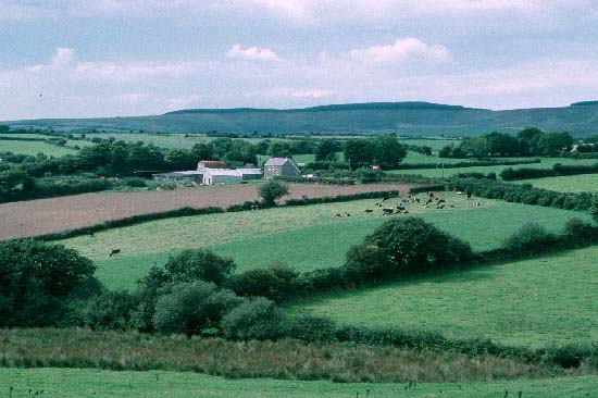
Description and essential historic landscape components
Llangolman is a large historic landscape area lying across several parishes
and encompassing the upper part of the valley of the Eastern Cleddau and
its tributaries. The valley floors here lie at about 60m to 80m, but the
valley sides rise steeply to over 130m before levelling out onto undulating
ground between 130m and 200m. This area includes the valley bottom, the
valley sides and the higher ground above. The valley sides are heavily
cloaked in woodland - a mixture of semi-natural deciduous woods and 20th
century coniferous plantations. The remainder of the area is enclosed
into small, irregular fields. Boundaries are mostly earth banks topped
with hedges, but stone and earth banks and stone-faced banks are also
present. Hedges vary in condition. Most are well maintained, but some
are overgrown and neglected with gaps appearing. In a few instances hedges
have completely gone. Agricultural land-use is almost entirely improved
with very little rougher grazing and arable land. Several small isolated
deciduous woods, trees in overgrown hedgebanks and the dense woodland
on the steep valley sides mentioned above lend a heavily wooded aspect
to parts of this landscape, although on the higher ground trees are rare
apart from those in hedges. The settlement pattern is dominated by dispersed
farms, houses and cottages, with the hamlets at Llangolman and Rhydwilym
providing the only foci. Farmhouses are predominantly 19th century, in
the vernacular style, stone-built (cement rendered or bare stone), three
bays, two storeys, with slate roofs. Houses and cottages in a similar
style but of one and one-and-a-half storeys are also present as are examples
of late 18th-century or early 19th-century houses in the polite Georgian
tradition. It is likely that the cement rendering on some older houses
and cottages masks earth (clom) construction. 20th century houses in a
variety of styles and materials are scattered across the area, but are
not common. Included in this area is the small thatched cottage of Penrhos
now a museum owned by the County Council and furnished in a 19th century
style. Generally agricultural buildings are small, reflecting the size
of the holdings, and comprise single small, stone-built 19th century range;
mid 20th-century corrugated-iron barns and other structures; and small
late 20th-century steel-, concrete- and asbestos-built structures. However,
the few larger farms have a collection of 19th century stone-built outbuildings
set around a yard or in another semi-formal arrangement with the house
as well as extensive modern agricultural buildings. Within this area are
the three medieval church sites of Mynachlog-ddu, Llangolman and Llandeilo
Llwydarth, a large chapel at Rhydwilym, founded in 1688, and Llandeilo
Chapel. Pont Mynachlog-ddu (a bridge) was mentioned by George Owen in
c.1600. There are seven listed buildings in the area. Llangolman and Mynachlog-ddu
churches (mentioned above) are both listed, but only the latter retains
any medieval fabric. The scant remains of the medieval church at Llandeilo
Llwydarth are a Scheduled Ancient Monument and Grade II listed. Temple
Druid, an 18th century mansion by John Nash on a 15th century site, is
Grade II listed, while the courtyard, outbuildings and cottages are Grade
II* listed. Rhosfach House, Llangolman, and the telephone box outside,
are both Grade II listed. Abandoned quarries are a feature of the landscape.
There is a small caravan park and country club at Trefach Manor on the
extreme eastern fringe of this area. Apart from the A478 which crosses
the extreme eastern fringe of this area, transport elements of the historic
landscape are limited to narrow winding lanes and tracks which are bordered
by large hedge-banks
Recorded archaeology is rich and diverse. From the neolithic, it includes a scheduled chambered tomb (or standing stone?), another possible chambered tomb and a possible henge (or vallum enclosure?). From the bronze age are a scheduled standing stone, a round barrow, three possible standing stones and two possible round barrows, and a possible burnt mound. There is a scheduled iron age hillfort and another possible hillfort. Roman artefacts have been found. Early medieval features include the two Early Christian Monuments from Llandeilo Llwydarth (now in Maenclochog Church) and an inscribed stone from Gelli Dywyll. There are two holy wells, the one at Llandeilo Llwydarth with a tradition that the water was drunk from the skull of St Teilo. There is a possible medieval strip-field system and several mill sites, as well as the church and chapel sites. Post-medieval archaeology includes a wealth of quarry features including buildings, a sawpit and a world war two searchlight battery on Llangolman Common.
Llangolman historic landscape character area is well defined to the north where it bounds Rhosfach and Mynachlog-ddu areas and to the east against Glandy Cross. To the south the boundary is less clear, although the area to the south consists of larger farms and larger fields than those of Llangolman. A definite boundary does not exist, but rather a zone of transition extending for perhaps one or two kilometres.
Sources: Charles 1992; Davies 1982; Dyfed Archaeological Trust 1997; Howells 1977; Howells 1987; Llandeilo Llwydarth tithe map and apportionment, 1841; Llandisilio tithe map and apportionment, 1840; Llangolman tithe map and apportionment, 1841; Llanycefn tithe map and apportionment, 1847; Lewis 1969; Lewis 1975; Ludlow 1998; Owen 1897; Pembrokeshire Record Office D/EE/7/338; Richard 1935; Richards 1998