|

264 CANTREF CEMAES 
GRID REFERENCE: SN 168310
AREA IN HECTARES: 190.6
Historic Background
A narrow strip of land in modern Pembrokeshire, on the eastern edge of
Mynydd Preseli. It lay within the medieval Cantref Cemaes which was brought
under Anglo-Norman control by the Fitzmartins in c.1100. The Fitzmartins
retained it, as the Barony of Cemaes, until 1326 when they were succeeded
by the Audleys. The Barony was conterminous with the later Hundred of
Cemais, which was created in 1536, but many feudal rights and obligations
persisted, some until as late as 1922. Like most of the southeastern part
of the Barony within Mynydd Preseli, the Crugiau Dwy character area continued
to be held under Welsh systems of tenure. In 1118, William Fitzmartin
granted the area, as part of the grange of Nigra Grangia, to the Tironians
of St Dogmaels Abbey. Its assessment at only half a knight's fee suggests
that the grange was probably mainly unenclosed moorland pasture during
the medieval period. At the Dissolution, it was acquired by John Bradshaw
of Presteigne, along with St Dogmaels Abbey, and was thereafter held distinct
from the Barony of Cemaes. It appears to have remained unenclosed moorland
common pasture until a relatively late date, and is now characterised
by a system of very large enclosures with straight boundaries, clearly
late post-medieval in origin but present by the 1840s when the tithe surveys
were undertaken. As the area lies between the Mynachlog-ddu character
area to the west, which was mainly enclosed during the 16th-18th centuries,
and the Pentre Galar character area to the east, which was enclosed in
1812, the large enclosures would appear to be earlier than 1812, but probably
not by many years. Charles Hassall's record, in 1794, of the 'extensive
waste' persisting in Mynachlog-ddu is reproduced in the County History.
There is now no settlement, and none is recorded on historic maps, but
the southern end of the area features a small disused slate quarry known
as Klondyke which was worked intermittently from the early 19th-century
(and possibly before), and was developed in 1910-12 when it employed 150
people before closure.
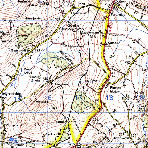
Base map reproduced from the OS map with the permission
of Ordnance Survey on behalf of The Controller of Her Majesty's Stationery
Office, © Crown Copyright 2001.
All rights reserved. Unauthorised reproduction infringes Crown Copyright
and may lead to prosecution or civil proceedings. Licence Number: GD272221
Description and essential historic landscape components
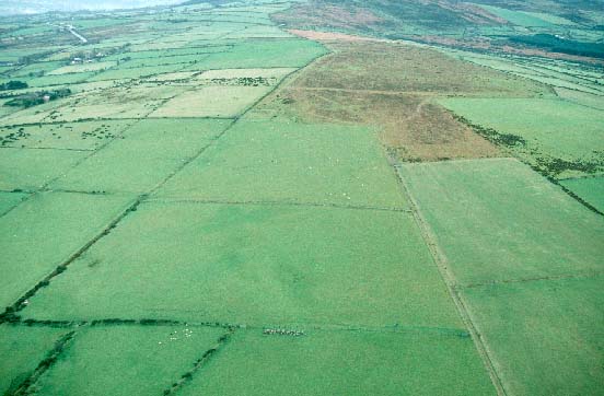
Crugiau Dwy historic landscape character area occupies a south-north rounded
ridge to the east of Mynydd Preseli. The ridge achieves a maximum height
of 360m. This area includes the flanks of the ridge down to about 280m.
To the south the ridge climbs to the summit of Foel Dyrch character area.
Old boundary banks are now redundant, and wire fences divide the area
into very large enclosures, but much of the landscape has an unenclosed
aspect apart from the northern end which has recently been transformed
into improved pasture and subdivided by wire fences into regularly-shaped
fields. However, land-use is predominantly rough grazing which contains
large pockets of heather and bracken. There are no standing buildings
within the area. Characteristic of the landscape are occasional clumps
of trees on the more sheltered eastern side of the ridge which mark the
sites of deserted farms and cottages. Apart from these trees and a small
20th century coniferous plantation on the southern flanks of the ridge,
this is a treeless landscape. The remains of a quarry are a prominent
aspect of the southern slopes of the area. There are no roads or tracks.
Recorded archaeology is limited to two, possibly three bronze age round barrows, and the remains of the post-medieval Klondyke quarry with extensive rubbish runs (one with a bridge), a collapsed drainage tunnel, and vestiges of a possible forge and powder house.
To the west, north and east the boundaries of this area are well defined by lower-lying enclosed land. Only to the south where this area runs into the unenclosed, higher hill of Foel Dyrch is there any similarity between this historic landscape character area and that of its neighbour.
Sources: Howells 1987; Llanfyrnach tithe map and apportionment, 1844; Llanglydwen tithe map and apportionment, 1846; Monachlogddu tithe map and apportionment, 1846; Rees 1932; Richards, 1998