|

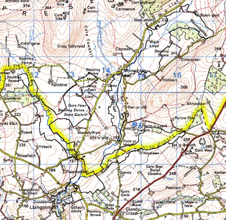
259 GORS FAWR - WAUN CLEDDAU 
GRID REFERENCE: SN127285
AREA IN HECTARES: 487.9
Historic Background
A large, irregular, dispersed area of unenclosed land in modern Pembrokeshire,
deeply cut into by the enclosed Mynachlog-ddu character area that occupies
the southern flank of Mynydd Preseli. It lay within the medieval Cantref
Cemaes which was brought under Anglo-Norman control by the Fitzmartins
in c.1100. The Fitzmartins retained it, as the Barony of Cemaes, until
1326 when they were succeeded by the Audleys. Like most of the southeastern
part of the Barony within Mynydd Preseli, the Gors Fawr-Waun Cleddau area
continued to be held under Welsh systems of tenure. In 1118, William Fitzmartin
granted this whole area, as part of the grange of Nigra Grangia, to the
Tironians of St Dogmaels Abbey. The grange was of considerable extent,
comprising 5 carucates which were worth £8 15s 6d in 1535. However, its
assessment at only half a knight's fee suggests that it was probably mainly
unenclosed moorland pasture during the medieval period. The inhabitants
of the Hamlet of Y Plwyf Bach, St Dogmaels parish, retained grazing rights
to the former grange into the 19th century. At the Dissolution, the grange
was acquired by John Bradshaw of Presteigne, along with St Dogmaels Abbey,
and was thereafter held distinct from the Barony of Cemaes. The records
of the Court of Augmentations suggests that some very limited attempts
at formal enclosure of the grange had taken place in the medieval period,
and possibly continued down to the early 19th-century. A small part of
the south end of the area belonged to Llwyn-yr-ebol, a grange of Whitland
Abbey, granted to the Cistercians by Maelgwn ap Rhys, son of Rhys ap Gruffudd,
between 1197 and 1231. It was also largely unenclosed pasture.The tithe
maps of c. 1840 show a similar situation to today's - unenclosed rough
pasture - apart from some very large divisions in some sections which
are now redundant, and some minor encroachments along the fringes of the
area. The area was a centre for slate production, which began early. Gilfach
Quarry had been leased from the former grange of Llwyn-yr-ebol by at least
1691, and its products were marketed as 'Whitland Abbey Slates'; it is
claimed that they roofed the Houses of Parliament. It is still in limited
production, but the quarries at Lower Tyrch in the centre of the area
- which were operational from the late 18th-century, and from which County
Hall, Carmarthen was roofed - closed in 1939.
Base map reproduced from the OS map with the permission
of Ordnance Survey on behalf of The Controller of Her Majesty's Stationery
Office, © Crown Copyright 2001.
All rights reserved. Unauthorised reproduction infringes Crown Copyright
and may lead to prosecution or civil proceedings. Licence Number: GD272221
Description and essential historic landscape components
Gors Fawr - Waun Cleddau character area consists of open, poor quality
land in the upper Eastern Cleddau and its tributaries. The area is divided,
separated or surrounded by the enclosed land of Mynachlog-ddu character
area. It lies between approximately 175m and 220m. The upper Eastern Cleddau
valley forms an open basin, the lower, gently-sloping sides of which are
clothed with fields and farms (Mynachlog-ddu character area), and the
valley floors (this character area) are poorly drained and unenclosed.
Virtually the whole area is given over to very rough grazing, with peat
bogs in the wetter, lowest lying areas. Apart from a little scrubby woodland
in some of the valley bottoms, and a small forestry plantation, this is
a treeless landscape. Redundant boundary banks attest to former attempts
to enclose parts of the area, and ditches are the remains of drainage
schemes. Occasional wire fences are now the only stock-proof boundaries.
There are extensive old slate quarries close to Pont Hywel. There are
no extant settlements in this character area. Lanes and tracks are unenclosed
by banks.
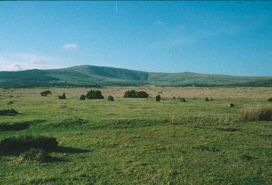
Recorded archaeology in the area is not dense, and is restricted in type. However, there are important prehistoric sites - the neolithic/bronze age Gors Fawr stone circle and a stone pair (all Scheduled Ancient Monuments). Later archaeology is mainly confined to quarry sites and accompanying features, ruined buildings, tramways and watercourses, but also included in this area is the Waldo Williams memorial stone. There is also a standing stone erected to the recent attempt at moving of a Preseli bluestone to Stonehenge.
There are two listed structures within the area. Pont Hywel Mill, on the finge of the area, is an 18th century corn mill which has been converted into a slate-carving centre open to the public. It is the only inhabited building in the area. Pont Hywel Bridge may be partly medieval - it was mentioned by George Owen in c.1600 - or in the medieval tradition. Other distinctive structures include the unlisted, post-medieval bridges at Pont Glandy and Pont Mynachlog-ddu. On most sides this area is bordered by the enclosed land of Mynachlog-ddu character area and other character areas of enclosed land such as Llethr and Llangolman. There is a clear and well-marked division between all these and Gors Fawr - Waun Cleddau character area. Sources: Dyfed Archaeological Trust 1997; Jones 1996; Lewis 1969; Lewis 1975; Llandisilo tithe map and apportionment 1840; Monachlogddu tithe map and apportionment 1846; Owen 1897; Pembrokeshire Record Office D/RTP/SKY 23; Pritchard 1907; Rees 1932; Richard 1935; Richards 1998; Williams 1990.