|

225 BETHLEHEM 
GRID REFERENCE: SN 690251 AREA IN HECTARES: 1737.00
Historic Background
A very large character area on the southeast side of the Tywi valley between
Llandeilo and Llangadog, including part of the lower Sawdde valley. During
the historic period the area lay within Cwmwd Perfedd of Cantref Bychan,
which was invaded by the Anglo-Normans advancing from the east under Richard
Fitz Pons who established a caput at Llandovery in 1110-16 (Rees n.d.).
It was acquired soon after by the Clifford lords of Brecon as the Lordship
of Llandovery. However, there were many episodes of Welsh rule and the
area retained native tenurial customs until the end of the Medieval period
when it was incorporated into modern Carmarthenshire. The eastern section
of this character area formed part of the patria of Llangadog which was
acquired by the Bishops of St Davids by the late 13th-century (Rees 1932).
The area may have been a focus for human settlement with status and/or
ritual associations from an early date. A Neolithic chambered tomb and
a Bronze Age standing stone lie centrally within the area. The large Iron
Age hillfort of Carn Goch, Area 222, intrudes into, and dominates Area
225, and was probably the centre of a large territory taking in most of
the area south of the Tywi. There is evidence for early occupation of
this site, possibly into the Neolithic, and the significance it gave to
the area may have persisted after its abandonment under Roman rule - the
most plausible villa site in southwest Wales, Llys Brychan, lies within
Area 225 only 1.6km to the northeast of the fort (Jarrett 1962). Its name
suggests that Llys Brychan was (re)occupied during the Medieval period
as an administrative centre or llys, with connections - putative or otherwise
- with Brychan, a dominant figure in early Medieval tradition. It is still
the site of a dwelling. By the post-Conquest period, however, the majority
of this area west of the Sawdde was administered within Cwmwd Perfedd
as Maenor Vabon, from a centre, Llys Hendy, now represented by the Post-Medieval
house at Manoravon/Crymlyn Manor (Rees 1932) recorded since the 18th century
(Jones 1987, 130). The continuing status of this area is demonstrated
by the perceived importance of the neighbouring Llangadog (Area 206) during
the Medieval period, with a chapel-of-ease to Llangadog parish at Capel
Tydist, the site of a house since at least the early 19th-century (Jones
1987, 21), and a further possible chapel site. Gentry houses are numerous
within the area, and many of them were acquired by the Dynevor estate
including Mandinam, established by the 17th century and said to have been
the residence of Jeremy Taylor following his chaplainship to the Earl
of Carbery at Golden Grove (Jones 1987, 7), and Tygwyn which was the residence
of the Vaughans of Derwydd in c.1650 with a demesne which comprised 214
acres in 1879 (Jones 1987, 190). Llwynymendy has origins within the 17th
century at the latest (Jones 1987, 121) as do Pentre Parr and Beili-Dyffryn
(Jones 1987, 7, 153), which later became part of the Dirleton estate.
Nevertheless the present pattern of enclosures, which was in place by
the early 19th-century (Llandeilo Fawr and Llangadog tithe maps), may
have been established by the Medieval period - they are very irregular
with many stands of ancient deciduous woodland. The steep-sided valley
of the Afon Sawdde is a natural line of communication and the A4069 was
a major Post-Medieval droving route, turnpiked from 1779 (Lewis 1971,
43). Typical 19th century rural development is exemplified by Bethlehem
which is a nucleation around Bethlehem chapel on the present Llandeilo-Llangadog
road - also a turnpike - and shown as a cluster of cottages in 1839, to
which a post office and school were added later in the 19th century (Sambrook
and Page 1995, 40). A 20th century housing estate has been added but overall
there has been little recent development.
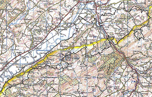
Base map reproduced from the OS map with the permission
of Ordnance Survey on behalf of The Controller of Her Majesty's Stationery
Office, © Crown Copyright 2001.
All rights reserved. Unauthorised reproduction infringes Crown Copyright
and may lead to prosecution or civil proceedings. Licence Number: GD272221
Description and essential historic landscape components
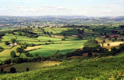
Bethlehem is a very large character area. It runs along the south
side of the Tywi valley from just southeast of Llandeilo upstream past
Llangadog and across the Sawdde valley. It rises in a series of low, rounded
hills from 30 m on the Tywi floodplain to over 130 m on the southeastern
flanks of the area. Dissecting the landscape are numerous small, steep-sided
valleys. Essentially this is a landscape of dispersed farms, small pasture
fields and small woods. Boundaries to the fields consist almost entirely
of earth banks topped with hedges, but a few stone-faced banks lie on
higher ground. Hedges are generally in good condition and are well maintained;
many have distinctive hedgerow trees. Land-use is predominantly improved
pasture, with very little rough and rushy land. Deciduous woodland is
mostly confined to the steep valley sides, where it provides a distinctive
landscape component. Close to the Tywi valley the landscape has a parkland
character; this is emphasised close to Crymlyn Manor by single trees and
small clumps which indicate old park planting. The are numerous small,
and one medium-sized conifer plantations in the area, mostly on higher
ground. There are no nucleated settlements, the loose cluster of houses,
a school and post office at Bethlehem is the only aggregate settlement
of note. Dispersed farms and other houses dominate the settlement pattern.
Most buildings are of 19th- and 20th-century date and stone built. There
is a range of farmhouse types, but the majority are two-storeys and three-bays
and in the vernacular tradition or more polite 'Georgian' style of the
early- to mid-19th century. Larger dwellings are present, and smaller
houses and cottages. The range of old, stone-built, 19th century farm
buildings also reflects prevailing social and economic class; most are
substantial ranges, often semi-formally arranged around a yard, though
single ranges of smaller buildings are present on the smaller farms. Nearly
all farms have modern agricultural buildings. Superimposed onto the old-established
pattern of dispersed farms is a scattering of a small number of later
19th- 20th-century dwellings, in a variety of styles and materials.
Recorded archaeology is rich and diverse, comprising one definite and one possible Neolithic chambered tomb/Bronze Age long barrow, a Bronze Age standing stone and a possible round barrow. Also there is a further Iron Age hillfort on the western slope of Carn Goch (Area 222), and another hillfort to the west. Llys Brychan was excavated in 1961 when it was concluded to be a probable Roman villa site (Jarrett 1961). From the Medieval period are a chapel site and possible chapel site, while from the early Post-Medieval period are possible pillow-mounds, a well and a rubbing stone, in addition to enclosures of unknown date.
There are many distinctive buildings, and high-quality farmhouses. Mandinam house is Grade II listed and mainly from the 18th- and 19th-century, with double-saddle roofs. The contemporary houses at Tygwyn, Llwynymendy, Pentre Parr with its lodge and park, and Beili-Dyffryn are unlisted. The present farmstead at Llyshendy was built for the Dynevor estate (Judith Alfrey, pers. comm.). The chapel, school and post office at Bethlehem should be noted, in addition to mills, cottages and dwellings, bridges and a smithy site.
To the north this character area is well defined by the flood plain of the Tywi valley and by Felindre character area. Where this area borders higher ground boundary definition is also good - to the south against Carn Goch, Garn-wen and others, but elsewhere there is a zone of change rather than a hard-edged border.