|

218 NANT-Y-FFIN 
GRID REFERENCE: SN 728468
AREA IN HECTARES: 482.60
Historic Background
A small area that unites three narrow, linear belts of land that follow
the valley floors of the Upper Tywi, Doethie and Gwenffrwd, in the foothills
of Mynydd Malláen and the Cambrian Mountains. The 'ffin' element is derived
from the ancient boundary which, historically, divided this area between
Cantref Bychan to the east and Cantref Mawr to the west. Cantref Bychan
was invaded by the Anglo-Normans under Richard Fitz Pons who established
a caput at Llandovery in 1110-16 (Rees n.d.) and was acquired soon after
by the Clifford lords of Brecon as the Lordship of Llandovery. Cantref
Mawr remained an independent Welsh lordship until 1284. Both retained
native tenurial customs until the end of the Medieval period when they
were united within modern Carmarthenshire. Evidence for human activity
within the area has considerable time depth - a Neolithic chambered tomb
lies at Gelli. The chapel of Ystrad-ffin is dedicated to Paulinus, the
reputed teacher of St David (Jones 1994, 88) whose biographer described
his community as comprising, by the 9th century, 'numerous buildings'
(Sambrook and Page 1995, 4). This may not refer to the present chapel
site, however, which was first mentioned in 1339 when it was confirmed
upon the Cistercians of Strata Florida (Ludlow 1998). There is a llys
place-name in the western part of the area, while much of the area east
of the Tywi lay within the Manor of Nant-y-bai, which was granted, as
a grange, to Strata Florida Abbey, probably by Gruffydd ap Rhys, in c.1200.
The grange nucleus may have lain at Bron-y-cwrt (Area 216), or within
this area where there is a substantial bloc of tithe-free land (Williams
1990, 58); the present farmstead of Ystrad-ffin may, moreover, have early
origins. As an upland grange Nant-y-bai was probably operated by tenant
farmers primarily concerned with the mountain pasturing of animals, although
there are indications that arable was undertaken in pockets of good soil
(Sambrook and Page 1995, 18), while it is likely that the pattern of enclosures
on the fertile valley floor was in place by the late Medieval - early
Post-Medieval period. The Manor of Nant-y-bai remained together after
the Dissolution, as the Ystrad-ffin estate, which was centred on the farmstead
of the same name (Carmarthenshire Record Office, Lort Muniments 17/678).
The farm has associations with Twm Sion Catti, a picturesque and nomadic
character of the 17th century who is said to have married a widow residing
here; he later became Mayor of Brecon and Sheriff of the county. A manorial
fish trap lies near the chapel. Lead mining was once undertaken in the
area and may have begun under the Cistercians (Williams 1990, 58), or
even the Romans (James 1982, 34). It was already being undertaken by the
late 13th-century, the crown taking the 'eleventh foot' of the ore in
taxation (Rees 1968), but had largely ceased by the late 19th-century.
There has been little subsequent development
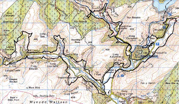
Base map reproduced from the OS map with the permission
of Ordnance Survey on behalf of The Controller of Her Majesty's Stationery
Office, © Crown Copyright 2001.
All rights reserved. Unauthorised reproduction infringes Crown Copyright
and may lead to prosecution or civil proceedings. Licence Number: GD272221
Description and essential historic landscape components
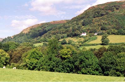
This area consists of the narrow deeply incised valleys of the Tywi,
Doethie and Gwenffrwd, and their tributaries. Only the valley floors and
lower slopes are included - higher valley sides have been allocated to
neighbouring areas. Valley floors lie between 120 m at the lowest point
to over 200 m towards the sources of the rivers. Within this area valley
sides rise to over 260 m, and continue to rise to over 450 m outside.
Steep slopes are cloaked with dense deciduous woodland. The main historic
components consist of dispersed farms and small irregular fields. Improved
pasture dominates, though there are pockets of rougher ground. Boundaries
are mainly of earth banks topped with hedges; some stony banks and collapsed
dry-stone walls have also been noted. Hedges are generally not in good
condition and many are overgrown or derelict. Apart from the large Ystrad-ffin
farm which lies on the edge of the wide flood plain of Nant-y-Ffin, farms
are relatively small and located on valley sides. Most farmhouses are
of 19th century date, stone-built with slate roofs and of two storeys.
Most are of three bays. There is a roughly equal proportion of those in
the vernacular tradition and those in the polite Georgian style. Outbuildings
are stone-built, and generally quite small and of a limited range. Some
are compacted into a single range. Many farms have modern agricultural
buildings. There is little modern housing development in the area.
Recorded archaeology in the area is rich and diverse. A Neolithic chambered tomb is associated with finds and an enclosure. There is a Bronze Age standing stone and a possible clearance cairn or round barrow and a possible Iron Age hillfort. Medieval sites comprise the chapel, a possible cross and a possible llys site. Further possible sites are represented by landforms.
There are some distinctive buildings. St Paulinus, Ystrad-ffin, was rebuilt in 1821 (Ludlow 1998) and is not listed. Ystrad-ffin Farmhouse is Grade II listed and said to be of 17th century or earlier origin, although externally the present structure is a plain building of 18th- or 19th-century appearance. Other buildings include two nonconformist chapels, mills, and 18th- and 19th-century dwellings and farms.
Characteristically, this is a very distinct area with clearly defined boundaries - this area is bounded by open moorland or forestry. Only to the south is there some difficulty of definition.