|

217 CWM-Y-RHAEADR 
GRID REFERENCE:
SN 765435
AREA IN HECTARES: 246.40
Historic Background
A small area on the steep eastern flank of Mynydd Malláen, lying within
the former Cwmwd Malláen of Cantref Mawr which remained an independent
Welsh lordship until 1284, and largely retained native systems of tenure
throughout the Medieval period. It also lies within the ecclesiastical
parish of Cilycwm which may have later Medieval origins in the 14th century
(Ludlow 1998). The area has little contemporary settlement, which reflects
its historic usage; however, the name 'Dinas' may represent an Iron Age
hillfort for which there appears to be no physical evidence. The area
is depicted as open pasture on the earliest historic maps and is still
largely unenclosed, and the presence of a sheepfold testifies to its predominantly
pastoral use. Such farmsteads and enclosures as exist mainly relate to
18th- and early 19th-century encroachment into former open land. There
is a small former lead mine on the eastern edge which may have early origins.
Mining was being undertaken in this area by the late 13th-century, the
crown taking the 'eleventh foot' of the ore in taxation (Rees 1968), but
had largely ceased by the late 19th-century. Much of the area has been
subject to later 20th century conifer plantation under the (then) Forestry
Commission.
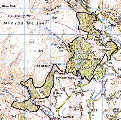
Base map reproduced from the OS map with the permission
of Ordnance Survey on behalf of The Controller of Her Majesty's Stationery
Office, © Crown Copyright 2001.
All rights reserved. Unauthorised reproduction infringes Crown Copyright
and may lead to prosecution or civil proceedings. Licence Number: GD272221
Description and essential historic landscape components
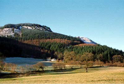
This character area lies on the steep valley sides of the Tywi and its
tributaries. The height range of this area is between 140 m and over 300
m. Apart from a little deciduous woodland on lower slopes, some open moorland
on steep slopes, and an old small farmstead - Cwm-y-Rhaeadr - with a few
adjacent fields, this whole area is under 20th century conifer plantations.
Most of these plantations were established on unenclosed moorland on the
steep valley sides. The only exception to this is at and around Cwm-y-Rhaeadr
where former fields were planted over.
There is little recorded archaeology, being confined to the possible Iron Age hillfort site, the lead mine and buildings.
None of the buildings are distinctive, comprising 19th century cottages and farms, a sheepfold and 20th century water towers.
This is a distinct area, and stands in contrast with the open moorland to the west and enclosed farmland to the south, north and east.