|

215 CILYCWM 
GRID REFERENCE: SN 757401
AREA IN HECTARES: 847.10
Historic Background
An area either side of the River Tywi, around the present village of Cilycwm.
It once lay within Cwmwd Malláen of Cantref Mawr which remained an independent
Welsh lordship until 1284, and largely retained native systems of tenure
throughout the Medieval period. Early origins have been claimed for the
nucleation around Cilycwm parish church (Sambrook and Page 1995, 17) but
the church is omitted from the Taxatio of 1291 and not mentioned until
1347 (Ludlow 1998). The village green survived into the 19th century as
an open parcel of land opposite the church (Sambrook and Page 1995, 23).
Cilycwm became the centre of droving activity in the 18th century and
doubtless benefited form the establishment of a small lead mine at Pen-y-rhiw-Rhaiadr
to the north of the character area. It had developed into an important
village by the early 19th century, but with 'untidy', mud-walled, reed-thatched
houses, which were replaced through the century by the present stone structures
including neat rows of terraced cottages. By the end of the century it
had many civic amenities - a school, a chapel, a Post Office and a vicarage
(Sambrook and Page 1995, 23). The present pattern of large, fairly regular
enclosures within the area may have been a product of the 17th- or early
18th-century, and associated with the gentry houses, of which there are
a number in the area, although none earlier than the 17th century. They
are dominated by the Neuadd Fawr estate which, under the Davys family
from the early 19th century onwards, absorbed many of the holdings in
Area 215 (Judith Alfrey, pers. comm.). Neuadd Fawr was first mentioned
in 1603 (Jones 1987, 138) but became ruinous in the latter half of the
20th century. Abergwenlais was the home of the Price family from 1680
until the later 19th century when it was rebuilt for the Neuadd Fawr estate
(Judith Alfrey, pers. comm.). Cefntrenfa was the home of the Lewis Bowens
from the late 17th-century (Jones 1987, 28), while Erryd is marked on
Emmanuel Bowen's map of 1729. Twentieth century development is confined
to housing at Cilycwm village and a small sewage farm to the south.
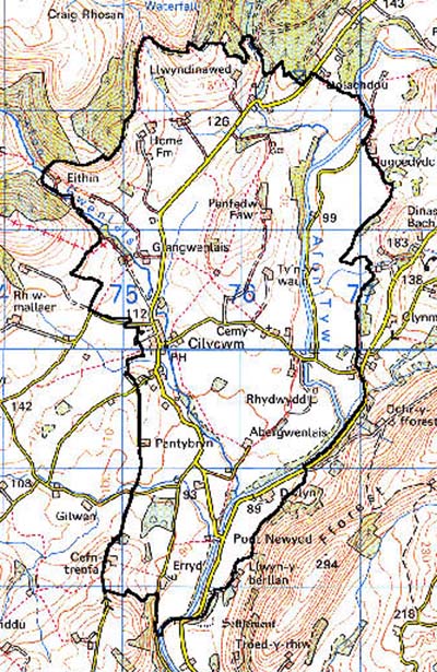
Base map reproduced from the OS map with the permission
of Ordnance Survey on behalf of The Controller of Her Majesty's Stationery
Office, © Crown Copyright 2001.
All rights reserved. Unauthorised reproduction infringes Crown Copyright
and may lead to prosecution or civil proceedings. Licence Number: GD272221
Description and essential historic landscape components
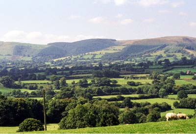
Cilycwm character area lies across part of the upper Tywi valley and across
a wide tributary valley. The Tywi valley in this area widens out from
its more constricted course downstream, before narrowing again upstream,
to the north. The floor of the valley lies at about 100 m, with the lower
valley sides within this area rising to a maximum of about 180 m. Essentially
this area is characterised by dispersed farms, small irregular fields
and woodland. The whole area is enclosed into fields. Fields on valley
sides are small and irregular; those on the valley floor are larger and
have a more regular shape. Improved pasture dominates, but, especially
on the valley floor where the course of the river is sluggish, there are
large pockets of rough, wet and rushy ground. A little arable is present.
Boundaries are of earth banks topped with hedges. Apart from alongside
roads and tracks, hedges are not in good condition; some have entirely
gone, others are reduced to lines of straggling bushes, most are overgrown.
Wire fences provide the main stockproof boundaries. Many hedges contain
distinctive hedgerow trees, and these together with the many small stands
of deciduous woodland lend a wooded appearance to parts of this character
area. Parkland lies close to Glanrhosan House. The nucleated village of
Cilycwm lies in the centre of the area. Cilycwm essentially consists of
a single street of dwellings, with the Medieval church at its centre.
Terraces of 18th- and 19th-century stone-built houses and cottages - the
larger houses in the Georgian style, smaller houses and cottages in the
vernacular tradition - are situated at the heart of the village. Small-scale
late 20th-century housing lies on the fringes of the settlement. The settlement
pattern of the area is however dominated by dispersed farms. Although
the buildings on these farms date mostly to late 18th- and 19th-century,
a wide range of social and economic classes is represented, from minor
gentry houses complete with home farms, to small farmhouses in the vernacular
tradition with a single small range of outbuildings. Most farmhouses,
however, are two-storey and stone built. Although examples of the simple
three-bay farmhouse in the vernacular tradition are present, those which
are larger and exhibit polite architectural consideration constitute the
majority. These larger farmhouses have a larger and wider range of 19th
century stone-built outbuildings associated with them than smaller examples,
often arranged in a semi-formal pattern around a courtyard. Most farms
have large modern agricultural buildings.
Recorded archaeology is mainly represented by the buildings but includes an unknown findspot, and the lead mines.
There are a large number of distinctive buildings, many of them gentry houses, of which c.35 are listed. The landmark Medieval parish church, with a tower, is Grade I listed. Neuadd Fawr, its coach house and stable are each Grade II listed, and accompanied by the home farm. Abergwenlais house, farm, mill and outbuildings, with late 18th century origins but rebuilt for the Neuadd Fawr estate in the late 19th century, are each Grade II listed. Cefntrenfa house, barn and outbuildings are 18th century and each is Grade II listed - large gardens with fruit trees, stable and dovecot were mentioned in 1812 (Jones 1987, 28). Erryd is mid 18th century and Grade II* listed. The majority of the remainder of the listed buildings are in Cilycwm village and include the vicarage, mill, post office, school, chapels and dwellings.
Although this is a fairly distinct character area, both historically and geographically, some neighbouring areas contain similar historic landscape components - in these cases, to the east, south and southwest there is a zone of change rather than a hard-edged border. To the north forestry on steep valley sides provides a clear boundary. Character areas to the west have yet to be defined.