|

213 MAESLLYDAN 
GRID REFERENCE: SN 779353
AREA IN HECTARES: 279.70
Historic Background
A small area around Maesllydan Hall to the northeast of the town
of Llandovery, mainly in the floodplain of the Afon Brân. The Roman road
from the fort at Llandovery (Alabum) crossed the area from southwest to
northeast, and led to the forts at Beulah and Castell Collen (James 1982,
7). Its course is more-or-less followed by the present A483(T). A cropmark
possibly relating to a vicus beyond the northeast gate of the fort, which
was probably established in the AD 50s (James 1991, 54), has been observed
in this area. During the historic period the area lay within Cwmwd Hirfryn
of Cantref Bychan, which was invaded by the Anglo-Normans under Richard
Fitz Pons who established a caput at Llandovery in 1110-16 (Rees n.d.)
and was acquired soon after by the Clifford lords of Brecon as the Lordship
of Llandovery. It largely retained native tenurial customs until the end
of the Medieval period when it was incorporated within modern Carmarthenshire.
However, Area 213 lay within the liberty of the Medieval borough of Llandovery
(Rees 1932), and appears to have operated an open-field system along Anglicised
models. Subsequent development in the area was dominated by Maesllydan
Hall which was established at an unknown date during the Post-Medieval
period. It was recorded in 1803 as the home of the Lloyd-Harries family
with an estate that eventually comprised 4000 acres in Carms., Cards.
and Brecs. (Jones 1987, 127); the house burnt down in 1977 (ibid.). The
disposition of the fields within the area suggests that the present pattern
of large, fairly regular enclosures may have been a product of the 17th-
or early 18th-century, and coeval with the establishment of the Hall,
supplanting the open-field system. The area is crossed by the railway
from Llandovery to Llanwrtyd Wells, which had been established by 1871
to form part of the London and North Western Railway (LNWR) Central Wales
and Carmarthen Junction Line. It is still operational and forms part of
the 'Heart of Wales' line.
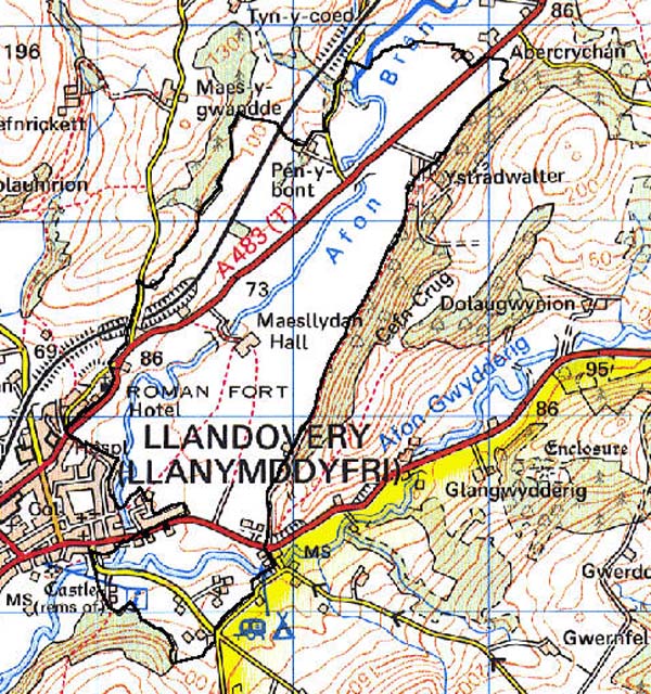
Base map reproduced from the OS map with the permission
of Ordnance Survey on behalf of The Controller of Her Majesty's Stationery
Office, © Crown Copyright 2001.
All rights reserved. Unauthorised reproduction infringes Crown Copyright
and may lead to prosecution or civil proceedings. Licence Number: GD272221
Description and essential historic landscape components
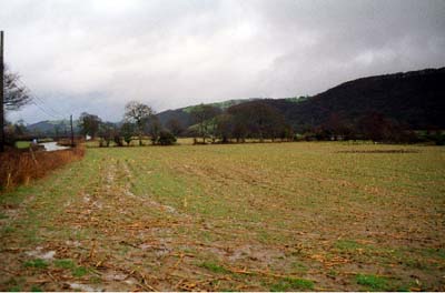
Maesllydan character area lies across the floodplains and lower valley
sides of the Afon Brân and Afon Gwydderig at a height of between 80 m
and 90 m. It consists of improved pasture divided into medium-sized fairly
regular fields, with a settlement pattern of several widely dispersed
farms and other dwellings. Field boundaries are hedges without banks and
earth banks topped with hedges. The former are planted on the valley floor
presumably to facilitate flood-water drainage. Hedges are moderately well
maintained, but some are becoming overgrown and others semi-derelict.
Wire fences supplement hedges. Some distinctive hedgerow trees are present.
There is very little woodland. Well defined ridge and furrow is located
across the valley floor to the south of Llanfair-ar-y-bryn, and may well
be present elsewhere. This ridge and furrow, historic map evidence of
enclosed strip-fields, and the place-name Maesllydan, all suggest an open
field system was located here. Farms are large and all have a substantial
range of 19th century stone-built outbuildings, some placed in a semi-formal
arrangement. Modern dispersed dwellings in a variety of styles and materials
in the southern part of this area are a result of the proximity of Llandovery.
There is possible topographic and earthwork evidence for emparking northeast
of the site of the former Maesllydan Hall. The Afon Brân is an important
route corridor, as demonstrated by the former Roman road and the current
A483(T) which runs through this character area.
Recorded archaeology comprises the cropmark (vicus?), ridge-and-furrow earthworks, the below-ground remains of Maesllydan Hall, and a possible park earthwork.
There are now no distinctive buildings. Several of the farmhouses have been rebuilt and replaced with modern bungalows and houses; older surviving examples are stone-built with a degree of architectural consideration, rather than in the vernacular tradition. A Post-Medieval mill lies within the area.
This is a self-contained distinctive area, and contrasts with areas of smaller, more irregular fields to the north and southwest, and with Llandovery urban area to the west. Character areas to the south have yet to be characterised.