|

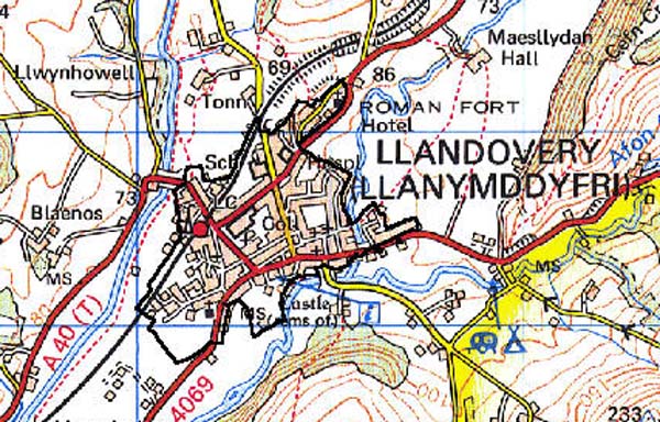
212 LLANDOVERY 
GRID REFERENCE: SN 767345
AREA IN HECTARES: 86.14
Historic Background
A small area corresponding with the present built-up town of Llandovery.
The Romans established a fort at Llanfair-ar-y-bryn (Alabum) in the north
of the present town, probably in the AD 50s (James 1991, 54). It was connected
by road to the forts at Carmarthen (Moridunum) and Brecon (?Cicutio) ,
now followed by the A40(T), and to the mid Wales forts at Beulah and Castell
Collen (James 1982, 7) now followed by the A483(T). This route network
may have persisted into the post-Roman period, and Llandovery may have
been the site of a pre-Conquest ecclesiastical community associated with
the Medieval parish churches of St Mary, Llanfair-ar-y-bryn, and/or St
Dingat, Llandingat (Sambrook and Page 1995, 4). Neither church lies in
the centre of the town which suggests pre-Conquest origins. Llanfair church,
moreover, lies within the Roman Fort, while the field boundaries formerly
adjacent to Llandingat may have perpetuated the line of a large llan enclosure
(ibid.). In the early 12th-century, Richard Fitz Pons, an Anglo-Norman
lord, established a castle at Llandovery (Soulsby 1983, 162). It is likely
that a small settlement soon developed at the foot of the castle mound,
perhaps within the outer bailey. Burgesses are recorded in 1185 (Arber-Cooke
1975, Vol. 1, 82), and in 1201 the Annales Cambriae refer to a town. Its
growth was encouraged under the Welsh princes during their episodic tenure
- the priory cell founded by Fitz Pons at Llanfair was closed by Rhys
ap Gruffydd in the same year when the brethren, who had been interfering
with the townsfolk, were expelled. Throughout the 13th century the castle
was frequently attacked, regularly changing hands between the English
and Welsh. Consequently, it is likely that the town had little opportunity
to develop until a period of relative stability was ushered in during
the last two decades of the 13th century. Between 1299 and 1317 the number
of burgages rose from an estimated 37 to 81 (Evans 1913, 158). By the
end of the 14th century money from rentals had increased substantially,
suggesting concomitant growth in population. At this time three annual
fairs are recorded. Other documentary references indicate that Llandovery
was functioning as a borough, though no charter had been granted (Evans
1913, 172). Richard III granted a charter in 1485 (Soulsby 1983, 163).
By then the town seems to have been going through a period of stagnation
or decline, for when John Leland visited in 1535 he described it as 'but
one strete, and that poorely builded of thatchid houses' (Evans 1913,
56). In the early 17th-century Llandovery's most famous son, Vicar Prichard,
built a house on the eastern fringe of the town. His fame seemed to have
little impact on the general wealth of the inhabitants, and even his fine
house soon began to fall into disrepair. 76 burgages were recorded in
1659 (Evans 1913, 80), divided into six wards, including Velindre Ward
to the east side of the town containing 11 burgages. However, only 61
resident burgesses were recorded in 1661 (Evans 1913, 203). There seems
to have been little improvement in the town throughout the 18th century,
for when Malkin called in 1804 he described Llandovery town as, 'the worst
in Wales. Its buildings are mean, irregular and unconnected; its streets
filthy and disgusting'. In 1835 Llandovery was declared a 'rotten borough'
which was run for the benefit of the Glanbrân estate. There does, however,
seem to have been a general improvement in the conditions of the town
from the late 18th-century onwards, as evidenced by the many fine buildings
from this period. The town received impetus when the present A40(T) was
turnpiked in the late 18th-century, the college established in 1849, and
the railway which came in 1858. The latter is still operational as part
of the 'Heart of Wales' line. Later in the 19th century and throughout
the 20th century the town has experienced slow but steady growth.
Base map reproduced from the OS map with the permission
of Ordnance Survey on behalf of The Controller of Her Majesty's Stationery
Office, © Crown Copyright 2001.
All rights reserved. Unauthorised reproduction infringes Crown Copyright
and may lead to prosecution or civil proceedings. Licence Number: GD272221
Description and essential historic landscape components
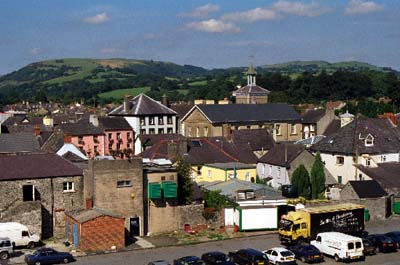
Llandovery is an urban character area. The heart of this area comprises
Llandovery town which lies on a terrace at approximately 65 m between
the Afon Tywi and Afon Brân, but also includes the parish church of Llandingat
located some 300 m to the southwest, and the Medieval church of Llanfair-ar-y-bryn
which is located on a hillock within the standing earthworks of the Roman
fort, several hundred metres northeast of the town. Both these churches
are linked to the town by 19th- and 20th-century development. The centre
of the town consists of Kings Road, Market Square and High Street. Buildings
on these streets mostly date to the late 18th- and 19th-century and are
stone-built, rendered, of three- or sometimes two-storeys and in the Georgian
tradition, although a number of the commercial premises have been rebuilt
in the 20th century. The masonry remains of the Medieval castle lie to
the south of the town centre and are separated from it by a car park.
Castle Street, which runs down towards the castle from the northeast,
contains stone-built houses and cottages mainly of 18th- and 19th-century
date. Mid- to late-19th-century residential development is concentrated
along Broad Street and the eastern end of High Street, and takes the form
of terraced stone-built, rendered houses and 'villas'. Late 19th-century
housing in the form of terraced, stone-built housing, sometimes with brick
detailing, is concentrated to the north of the historic core of the town
around Stone Street, New Road and Queen Street. Llandovery College, constructed
in a distinctive Tudor Gothic style lies to the north of the historic
town core. 20th century residential development both pre- and post-World
War 2 is relatively modest in extent and consists mostly of small housing
estates, and linear development along the A40(T) to the north and south
of the railway station, along the A40(T) to the east and between the town
and Llanfair-ar-y-bryn. A modern industrial estate has been established
on the southwest fringes of the area.
Recorded archaeology mainly relates to the Roman fort and to the Medieval town, with its Post-Medieval buildings. It includes the scheduled Roman fort site, the Roman road and a probable Roman cemetery, and the Medieval churches, priory site and castle. There is also a Quaker burial ground from the Post-Medieval period, and an unknown earthwork.
There are many distinctive buildings. St Mary's and St Dingat's churches are both landmark churches with Medieval towers; St Mary's is Grade I listed and largely unrestored, with an early 18th century roof (Ludlow 1998) and listed churchyard furniture; St Dingat's is Grade II* listed with listed churchyard furniture. The remains of the Medieval masonry castle are scheduled and Grade II* listed. There is a total of 65 listed buildings, including the 17th century Llanfair Grange and 'Vicar Prichard's House', the 19th century college building in neo-Gothic style by G E Gingell of Bristol, vicarages, public houses, dwellings, chapels, bank building, post office, market hall, town hall and bridges. The 19th century cattle market and railway station are unlisted.
This is a compact urban character area and contrasts with neighbouring rural areas.