|

208 YSTRAD TYWI: LLANGADOG - LLANDOVERY 
GRID REFERENCE: SN 723316
AREA IN HECTARES: 925.40
Historic Background
A large, narrow area stretching from Llangadog in the southwest to Llandovery
in the northeast, which lies in the fertile alluvial floodplain of the
River Tywi. The valley was the major historic route corridor into West
Wales and the Roman road from Carmarthen to Llandovery, which lies just
within the northwest edge of this character area, followed the interface
between the alluvium and the solid geology of the north side of the Tywi.
A later turnpike more-or-less followed the course of this Roman road,
as does the present A40(T) - see Areas 182 and 196. The River Tywi in
this area is active and subject to course changes across the valley floor,
and the wooded nature of the valley was commented upon by early writers
including Leland in the 1530s (Smith 1906), who appear to be describing
the floodplain. Therefore, the present pattern of regular fields is probably
of later date, while. Enclosure may have been undertaken during the 18th
century, but had definitely taken place by the time the tithe surveys
were conducted in the second quarter of the 19th century. In addition,
settlement on the floodplain has always been minimal. There are, however,
a few farms and dwellings in the area, also occupying the interface or
situated upon glacially derived ‘islands’ within the floodplain;
one of these, Pentremeurig, has 16th century origins and was assessed
for 7 hearths in 1670 (Jones 1987, 155).The disposition of these habitations
may then reflect earlier settlement patterns. Peat deposits have been
noted between the alluvium and the underlying geology elsewhere within
the Tywi Valley (Page 1994, 4,9), where they were thought either to represent
such ‘islands’ in the floodplain, or a drying of the floodplain
(see also Area 196) and while no prehistoric sites have been recorded
within the area it must be stressed that within the Tywi Valley, this
period is among ‘the least known’ (Cadw/ICOMOS, 1998, 28).
During the Medieval period the river formed one of the major boundaries
of Carmarthenshire, separating Cantref Mawr on the north bank from Cantref
Bychan on the south bank (Rees, 1932). As such, the landscape area has
experienced a chequered history of tenure and was troubled by warfare
until the end of the 13th century; Cantref Mawr, unlike Cantref Bychan
which was subject to 12th century conquest and reconquest, remained an
independent Welsh lordship until 1284 (Rees 1953, xv) and the Post-Medieval
house at Ystrad may be the site of the Medieval llys of Gwestfa Ystradmynys
within which this area partly lay. There does not appear to have ever
been a bridge across the Tywi between Llangadog and Llandovery but there
were at least two, possibly three historic fords. The turnpike, established
in 1763-71 (Lewis 1971, 43) more-or-less followed the line of the Roman
road and is now represented by the A40(T). The A4069 on dry ground between
Llangadog and Llandovery on the south side of the valley also follows
the line of a turnpike begun in 1779 (ibid.). The floodplain, meanwhile,
is crossed by the former LNWR main West Wales railway line which was opened,
as the ‘Vale of Towy Line’, by the Llanelly Railway and Dock
Company in 1858 (Gabb, 1977, 76). Little industry has developed in this
area although a woollen factory possibly operated at Pentremeurig.
Base map reproduced from the OS map with the permission
of Ordnance Survey on behalf of The Controller of Her Majesty's Stationery
Office, © Crown Copyright 2001.
All rights reserved. Unauthorised reproduction infringes Crown Copyright
and may lead to prosecution or civil proceedings. Licence Number: GD272221
Description and essential historic landscape components
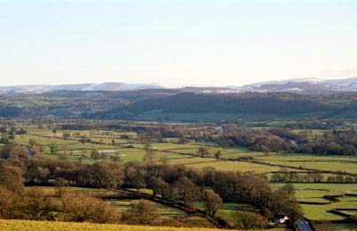
This area comprises the flood plain of the Tywi together with the lower,
gently sloping valley sides. Within this area the flood plain of the Tywi
rises some 20 m, from 40 m OD at the west end to 60 m OD at the east end,
over a distance of 7 km. The lower valley sides rise up to a maximum of
60 m to 70 m. Above these lower slopes valley sides rise steeply, particularly
on the northern side towards Llandovery, to over 150 m. This part of the
Tywi valley provides a natural route-corridor. The Romans utilised the
route for the Llandovery-Carmarthen road, and in more recent times turnpike
roads were constructed on both sides of the valley. The course of the
turnpike on the northern side is now followed by the A40(T), that on the
south side by the A4069. The railway that runs along the flood plain on
a low embankment also uses this route corridor. Where areas of deposition
and erosion are evident on the Tywi there is no strong field patterning,
and scrubby, rushy ground prevails. These areas are, however, fairly restricted
and most of the area is divided into reasonably regular, medium-sized
fields. Field boundaries are hedges without banks and earth banks topped
with hedges. The former are planted on the valley floor presumably to
facilitate flood-water drainage. Some hedges are accompanied by ditches.
Most hedges are well maintained, though a significant number are becoming
derelict. Wire fences supplement most hedges. Many hedges possess distinctive
hedgerow trees, and these, together with isolated trees and small copses
lend a parkland aspect to the area. This may be a planned effect, designed
to merge with the parks on the north side of the valley associated with
gentry houses. Settlements are confined to low terraces which lie slightly
above the flood plain and to the valley sides. A wide range of economic
and social classes are represented by the buildings of the area from the
gentry house of Ystrad, with an area of parkland, through to small roadside
cottages. However, the settlement pattern is dominated by farms dispersed
along a river terrace to the south of Llanwrda, on the lower slopes of
both sides of the river. Farmhouses are quite substantial and tend towards
the ‘polite’ with extensive, large semi-formal outbuildings,
mainly supplemented with modern agricultural buildings.
Recorded archaeology is confined to buildings and the ford sites.
There are many distinctive buildings but none are listed. They include the gentry house at Glan-Dulais, the 18th- and 19th-century Ystrad house and park, and Pentremeurig with 16th century origins. Farmhouses are generally quite substantial - more so than the simple two storey, three-bay structures common elsewhere - and generally of 18th- or 19th-century date, stone built and polite, rather than vernacular. 20th century brick-built farmhouses are also present. Farm buildings are also large and are often arranged in a semi-formal setting with the farmhouse. 19th century stone-built examples and 20th century brick outbuildings are represented, and most farms possess large assemblages of modern agricultural buildings
This is a fairly distinct character area, and contrasts with the character areas of enclosed farmland with smaller farmsteads that bound it to the north and south, with the urban areas of Llangadog and Llandovery, and with former parkland to the northeast.