|

205 CARREG-SAWDDE COMMON 
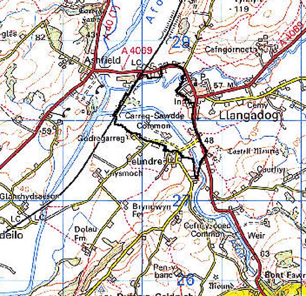
GRID REFERENCE: SN 702279
AREA IN HECTARES: 78.59
Historic Background
Carreg-Sawdde represents an area of remnant common within what may formerly have been a more extensive tract of unenclosed grazing. It lay within Perfedd commote of Cantref Bychan, which was, with the exception of Iscennen, invaded by the Anglo-Normans advancing from the east under Richard Fitz Pons who established a caput at Llandovery in 1110-16 (Rees n.d.); it was acquired soon after by the Clifford lords of Brecon as the Lordship of Llandovery. However, there were many episodes of Welsh rule, and the area retained native tenurial customs until the end of the Medieval period. The common appears to have become part of the patria of Llangadog when the area was acquired by the Bishops of St Davids in the later 13th century (Rees 1932), from which point the right of pasture appears to have belonged to the burgesses of Llangadog (Area 206). The common occupied more-or-less its present extent by at least 1839, when the tithe map of Llangadog parish recorded a landscape very similar to the present. There has been some limited subsequent encroachment particularly at the south-east end adjacent to Area 235 (Castell Meurig) and as 'islands' within the common, while some of the trackways depicted on early maps appear to have become disused.
Base map reproduced from the OS map with the permission
of Ordnance Survey on behalf of The Controller of Her Majesty's Stationery
Office, © Crown Copyright 2001.
All rights reserved. Unauthorised reproduction infringes Crown Copyright
and may lead to prosecution or civil proceedings. Licence Number: GD272221
Description and essential historic landscape components
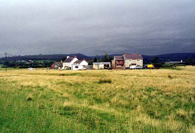
Carreg-Sawdde Common lies on the flood plain of the Afon Sawdde at approximately 45m. The A4069 (turnpike) road crosses part of the south-east side of the common. A B-road from Llangadog to Felindre crosses the common towards its southern end, and the Afon Sawdde over a 20th century bridge (occupying the site of an earlier crossing). The common is open, rough grazing land apart from a small 'island' of tightly-packed buildings in the centre, and a modern sewage treatment works. The buildings are encroachments on to the common and comprise late 19th century two-storey houses through to late 20th century bungalows.
Recorded archaeology is limited to a findspot of uncertain date.
There are no distinctive buildings
This open common contrasts to the nucleated settlement and associated fields of Felindre to the west, with Llangadog urban character area to the east, and with enclosed farmland and dispersed farms on other sides.