|

202 LLANDEILO 
GRID REFERENCE: SN 628221
AREA IN HECTARES: 131.30
Historic Background
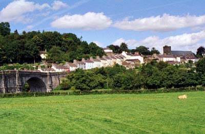
Llandeilo occupies a central position within the Tywi valley, once part of the lordship of Cantref Mawr which remained independent of Anglo-Norman rule until the establishment of the county of Carmarthen in 1284. However, settlement within the character area has earlier origins. The town stands astride the Llandovery (Alabum) -Carmarthen (Moridunum) Roman road, possibly at a junction with a further Roman road running south towards Loughor (Leucarum) suggesting that a bridge over the Tywi was present. A Roman fort midway between Carmarthen and Llandovery is to be expected in the area of the town and a possible site in the vicinity of Rhosmaen has been proposed (James 1992; Sambrook and Page 1995, 4). Settlement does appear to pre-date that at neighbouring Dinefwr (Area 195) in the form of the church of St Teilo (later the parish church of Llandeilo Fawr), supposed to have been established in the 6th century (Samuel 1868, 74), and mentioned in the pre-Conquest Lichfield Gospels (Ludlow 1998). By the 9th century Llandeilo Fawr was the most influential of the ecclesiastical communities in the district (Sambrook and Page 1995, 4), possessing two (formerly three) ECMs, and a spring in the large churchyard. It was appropriated to the Premonstratensian Abbey at Talley by Rhys Grûg in c.1215 (Price 1879, 166). The town is believed to have its origins within this small ecclesiastical community. It had certainly been established by 1213 when the 'town' was attacked and 'completely burned' (Jones 1952, 87), but its growth appears to have been encouraged by the Bishops of St Davids who acquired the town and patria in the late 13th century, and by 1306 it contained 30 burgesses and 11 other tenants (Soulsby 1983, 160). The town was granted a weekly market and three annual fairs (Willis-Bund 1902, 263-9), held in the large marketplace northwest of the church. A mill was also present and at least one subordinate chapel lay within the character area, but the Medieval town appears to have been confined to the area around the churchyard, the marketplace, Bridge Street, and the lower part of Rhosmaen Street. A bridge is mentioned in 1289 (Soulsby 1983, 161) but the present structure was erected in l848 by W Williams of Llandeilo replacing an earlier bridge downstream. Ffairfach developed as a settlement in the shadow of the town, south of the bridge, and was recorded as the site of an annual fair by George Owen in 1601 (Sambrook and Page 1995, 22). East of Ffairfach but within Area 202 lies the site of Tregyb, a former mansion established by the 16th century (Jones 1987, 186) on the site of a 14th century vill which may have had its own market (Rees 1932). A nearby 'maerdy' place-name, derived from a reeve or maer, may be associated with the monastic holding in Area 190 or the Tregyb estate (Sambrook and Page 1995, 17). Subsequent urban development was slow and probably did not occur until the 18th century. However, by 1841 the town had expanded to the north and west (Llandeilo Fawr tithe map) while the town was considered important enough to be the site for the County Midsummer Quarter Sessions (Soulsby 1983, 162). It was also a stage on the Mail Road which followed the course of the Roman road (and modern A40). It was turnpiked in 1763-71 (Lewis, 1971, 43) and was driven through the churchyard in the 1840s (Ludlow 1998). Rhosmaen grew as ribbon development either side of the road with, by the end of the 19th century, a chapel and industry including a tannery. The former LNWR main West Wales railway line, which was opened as the 'Vale of Towy Line' in 1858 (Gabb, 1977, 76) established a railway station in the town, encouraging growth to the north towards Rhosmaen. A further station was established in Ffairfach at the junction with the Llandeilo-Llanelli line, which had been laid down in the 1840s (Morgan 1958). Expansion to the west is effectively limited by Dynevor Park (Area 195) but the 20th century has seen council development north of the park and the establishment, near its entrance, of both a fire station and a police station.

Base map reproduced from the OS map with the permission
of Ordnance Survey on behalf of The Controller of Her Majesty's Stationery
Office, © Crown Copyright 2001.
All rights reserved. Unauthorised reproduction infringes Crown Copyright
and may lead to prosecution or civil proceedings. Licence Number: GD272221
Description and essential historic landscape components
The historic town is situated on the north bank of the River Tywi, occupying a river terrace which slopes downhill from west to east between 40 m and 80 m. It is dominated by the 16th century church tower which overlooks the bridge. Ffairfach lies on the south bank and the character area includes ribbon development either side of the A40(T) to the north. The town comprises an axial main street, Bridge/Rhosmaen Street, running northeast from the bridge, originally to bifurcate around the large churchyard. Rhosmaen Street formed part of the Carmarthen-Llandovery turnpike and later the A40(T). The subrectangular churchyard, which was the primary nucleus, is now bisected by this street but is still a large, open green space. Bridge Street leads uphill from the graceful, single-span bridge and is characterised by attractive colourwashed earlier 19th century dwellings of 2-3 storeys, behind and to the west of which rises the wooded hill of Penlan Park (Area 195). The marketplace northwest of the church is now occupied by infill; Carmarthen Street, leading uphill west from the marketplace, is occupied by a number of good quality buildings including the square, stone-built provision market of 1838. Rhosmaen Street largely features 19th-20th century development. In 1800 it was occupied by 'straw-thatched houses of the poorest description' (Soulsby 1983, 162) but now features the town's main Coaching Inn, the Cawdor Arms, from c.1845 and built around a courtyard, and a number of good-quality civic buildings from later in the 19th century - banks, former Post Office etc. New Road was constructed between Rhosmaen Street and Carmarthen Street in the later 19th century to avoid the constricted roads around the churchyard. A feature of the townscape are a number of alleys and informal courtyards, not properly accessible to wheeled traffic but featuring 19th century buildings, often from early in the century and of good quality. A number of later 19th century terraces are concentrated on the northern fringe of the town around the railway station. Both Ffairfach and Rhosmaen are linear, ribbon developments of the later 19th-20th century with their own chapels. Twentieth century development has largely occurred west of the historic core and north of Dynevor Park (Area 195) and is characterised by council-built housing. Llandeilo is free from satellite development and there is no retail or business developments outside the town, despite the completion of the northern bypass in 1994 which took east-west traffic away from the town centre; north-south traffic still passes through. Tregyb House was demolished in 1974 and the park is now largely occupied by the town Secondary School and grounds. However, the house platform and terraces survive - the former is the site of the Gorsedd stone circle from the 1996 National Eisteddfod - while the park retains much of its character including many distinctive trees.
Recorded archaeology comprises features from the Medieval - Modern periods which have been largely discussed but includes Roman findspots and the two ECMs from the 10th-11th centuries.
There are a large number of listed buildings - c.75 in this landscape area - which are mainly town houses and civic buildings. Also included are the church which was largely rebuilt in 1848-51 to the designs of Sir George Gilbert Scott, and the spring (both Grade II listed), the road bridge (Grade II* listed), the present rail bridge from 1898, the old provision market from 1838 and the Cawdor Arms (all Grade II listed), as well as several chapels.