|

201 CWM-IFOR - MANORDEILO 
GRID REFERENCE: SN 667276
AREA IN HECTARES: 1509.00
Historic Background
This is a large character area lying above the interface between the alluvium and the solid geology of the north side of the Tywi, and part of the main historic route corridor into West Wales. The Roman road from Carmarthen to Llandovery followed this interface. It forms the southeast edge of the character area (see Area 196) and its course has been more-or-less followed by the modern A40(T). The Roman road may perpetuate the line of an earlier routeway, or at least activity, as testified by stray finds of Bronze Age date found on or close to the road, including a gold hoard. The line of the Roman road was, however, abandoned during the Medieval and earlier Post-Medieval periods, until it was turnpiked in the 18th century. During the intervening period a routeway from Llandeilo to Llandovery, later with a toll-house, was established along the higher ground through the centre of this character area (Ludlow 1999, 24), when it lay within the southern half of the commote, and later hundred, of Maenordeilo (Rees 1932) which was held of the independent Welsh lordship of Cantref Mawr until the establishment of the county of Carmarthen in 1284. The relative homogeneity of the present landscape may represent a historical unity of land-use. The landscape had been enclosed, in the present pattern of irregular fields, by the time the tithe surveys were conducted in the second quarter of the 19th century, but the process may have been undertaken at an earlier date, possibly during the late Medieval period. Settlement on the floodplain itself has always been minimal but does occur on raised 'islands' within the alluvium, mainly in the form of isolated farms of which Glanrhyd-isaf may have early origins. The remains of an adjacent field system may be Medieval. On the higher ground, Post-Medieval building platforms, trackways etc. attest to former settlement around Banc-y-gwyn. The character area lay within the large parish of Llandeilo Fawr and has a strong ecclesiastical signature, perhaps representing the core of the pre-Conquest Patria of St Teilo. The many chapels-of-ease to the parish may have early origins and include several within this character area. One of these chapels was still visible in the early 19th-century when it became the site of a dwelling, Capel Isa, built on land originally belonging to the Abermarlais estate in Area 209 (Jones 1987, 21). The lower valley side is occupied by two, formerly three, more 'polite' houses and gardens, with a degree of emparking which has characterised the landscape. The most important is Glanbrydan, established during the later 18th century but extended, and laid out as a parkland landscape, between 1838 and 1887 with the construction of a lodge (Ludlow 1999, 26). Down Farm, is little more than a large farm whilst Dirleton near Llangadog Bridge has now largely been lost. The pattern of small farms within and around the area had been established by the early 19th-century, but there have been landscape changes including the loss of further farmsteads and the coalescing of fields near the valley floor, and the diversion of the turnpike road in the 1820s with the subsequent development of a village, with a church, at Cwm-Ifor (see Area 196). The nucleation at Manordeilo, too, is a creation of the 19th century and is not even named on the Ordnance Survey Original Surveyors' Drawings, Sheet 189, of 1812. Its greatest expansion has in fact occurred since 1964 (Ordnance Survey, 1:10000), and is still going on with new dwellings under construction at the northeast end.
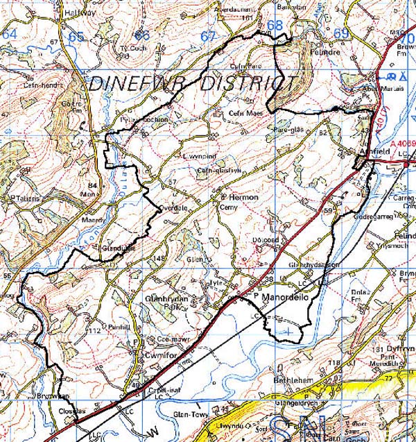
Base map reproduced from the OS map with the permission
of Ordnance Survey on behalf of The Controller of Her Majesty's Stationery
Office, © Crown Copyright 2001.
All rights reserved. Unauthorised reproduction infringes Crown Copyright
and may lead to prosecution or civil proceedings. Licence Number: GD272221
Description and essential historic landscape components
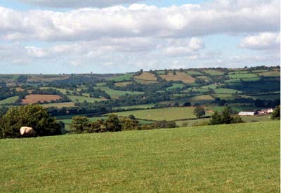
The Cwm-Ifor - Manordeilo character area occupies an area of rolling hills on the north side of the Tywi valley. From the valley floor at approximately 40 m the hills rise to a maximum of 160 m, though generally they lie between 50 m and 90 m. This is essentially a landscape of small irregular fields and dispersed farms. Land-use is almost entirely of improved pasture. Fields are divided by earth banks and hedges. Hedges are generally in good condition and well maintained, but there is some dereliction on low ridges north of Cwm-Ifor, close to Abermarlais (Area 209) at the eastern end of the area and on high ground to the north. Distinctive hedgerow trees are common, particularly in the areas of derelict hedges north of Cwm-Ifor. There are numerous copses and woodland stands, some possibly ancient, particularly on east and north-facing slopes of the Afon Dulais. The parkland at Glanbrydan and to a limited extent the old park of Dirleton merge and influence the surrounding agricultural landscape. The old established settlement pattern of dispersed farms consists mainly of stone-built houses of the 18th- and 19th-century. Although the date range of these surviving buildings is limited, a considerable economic and social range is present from gentry houses such as Glanbrydan House with its lodges and associated home farm, down to small dwellings in the vernacular tradition. Superimposed over the pattern of dispersed farms is a more recent linear and nucleated settlement pattern. Buildings of this pattern mostly date to the 20th century and tend to be concentrated along the A40 road, though the 19th century hamlet at Cwm-Ifor has been transformed into a small nucleated settlement by modern housing development.
Recorded archaeology mainly relates to the settlement already discussed, but includes an unknown cropmark, a possible round barrow and standing stone, as well as the gold hoard and stray finds. There are at least three Medieval chapel sites, a field system and a possible well, and Post-Medieval building platforms, leats, trackways and bridges around Banc-y-gwyn. The site of Dirleton House and park still contains landscape features.
Distinctive buildings include the Grade II listed Capel Isa, built in 1812-13 by Thomas Bedford of Llandeilo as a large, two-storeyed building, originally square in plan but extended west by one bay in the 19th century and now with a three-bayed southern facade. There is an associated, Grade II listed stable-range. The present Glanbrydan House and lodges are not listed, but the 'tower house' (former coach-house) is Grade II listed, probably built in 1885 to designs by S W Williams of Rhayader. Larger farms with concomitant larger farmhouses often in the Georgian tradition tend to be located on the lower slopes closer to the Tywi valley. These larger farms usually have a large assemblage of stone outbuildings in a formal arrangement. However the most common type of farm is a simple two-storey, three bay house in the vernacular tradition with a small group of outbuildings, sometimes compacted into a single range. Most farms have large, modern agricultural outbuildings associated with them. There are a number of early 19th-century cottages. St Paul's Church, Cwm-Ifor, is late 19th-century and on a new site but the chapel is from 1836. Further nonconformist chapels lie at Manordeilo and Hermon. An early 19th-century turnpike trust milestone on the A40(T) is Grade II listed, and an earlier toll-house lies on the old mail road.
This is not an easy area to define, as neighbouring areas possess similar characteristics. Only to the south against the flood plain of the Tywi is there good definition. Elsewhere there is a zone of change.