|

193 GOLDEN GROVE/GELLI AUR 
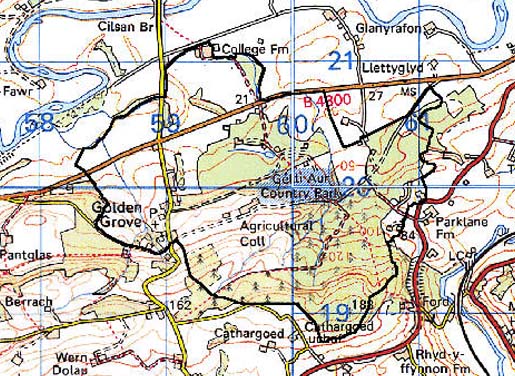
GRID REFERENCE: SN 597199
AREA IN HECTARES: 385.90
Historic Background
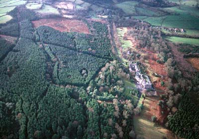
A small area on sloping ground to the south of the River Tywi. It is coterminous with the northern half of Llanfihangel Aberbythych parish and largely comprises Golden Grove Park, an estate landscape of the 17th- to 19th-century. It occupies the central part of Iscennen commote which, unlike the rest of Cantref Bychan within which it lay, remained nominally independent of Anglo-Norman rule until 1284 when it was acquired by John Giffard. In 1340 it became a member of the Duchy of Lancaster (Rees 1953, xv-xvi). The parish church of St Michael, Llanfihangel Aberbythych, has a circular churchyard and a possible early Michael dedication. Although there is no documentary evidence for a church here prior to the early 17th century, the tradition that it was originally located elsewhere is highly dubious (Ludlow 1998). A high-status house appears to have been present at Golden Grove from the 16th century under the Vaughans, later Earls of Carbery, and afterwards, under the Earls of Cawdor (Jones 1987, 84). There is no evidence for any previous settlement or dwelling of importance (Jones 1962, 259). The house was rebuilt in 1754-7 and again in 1826 after the early 18th century house had apparently been demolished. The former site, however, continued to be used as a walled kitchen garden and was modified several times until the present day. On a more elevated position and about a kilometre from the sites of the earlier mansions, the new house was designed by the architect Wyattville (Whittle 1999). The Vaughans were pioneers of agriculture and silviculture and, at its height, the Golden Grove estate comprised over 50,000 acres spread through southwest Wales (Jones 1962, 258). Under estate management, the village of Golden Grove/Gelli Aur was developed around St Michael's church, and later in the 20th century, council housing was erected to the north. Golden Grove house was occupied by the US Air Force during World War II and in 1952 a lease on the house and park was granted to Carmarthenshire County Council who used the site as an Agricultural College (Jones 1987, 84); the buildings are now a satellite for Carmarthen College of Technology and Art (Wildlife Illustration), whilst part of the grounds is designated as a country park.
Base map reproduced from the OS map with the permission
of Ordnance Survey on behalf of The Controller of Her Majesty's Stationery
Office, © Crown Copyright 2001.
All rights reserved. Unauthorised reproduction infringes Crown Copyright
and may lead to prosecution or civil proceedings. Licence Number: GD272221
Description and essential historic landscape components
The core of this area, which lies on gentle north-facing slopes between 20 m and 180 m on the south side of the Tywi valley, comprises the demesne of Gelli Aur. As much of the former parkland of Gelli Aur has now decayed and taken on a character similar to the surrounding landscape, this character area is somewhat larger than the former demesne. Tree planting, garden terraces and pleasure grounds of the 19th century, including an arboretum, survive, but much of the grounds and land outside the former parkland to the south of the mansion have been planted with conifers during the second half of the 20th century. To the south of the extant mansion, the site of the old mansion is marked by a walled garden, a lake and a canal. The demesne is surrounded by a mortared wall, but this is now in a poor state of repair. Included in this area is the village of Llanfihangel Aberbythych. This is essentially an estate village, and the mid 19th-century church, a school, dwellings and lodges built in a Victorian Tudor Gothic style, together with other estate buildings away from the village provide a distinctive architectural signature to this area. To the south of the old mansion the straightened length of the B4300 and the straight road that leads to Cilsan Bridge across the Tywi attest to former estate management. Outside the demesne farmland has been enclosed into small- to medium-sized fields by earth banks and hedges. Hedges contain distinctive hedgerow trees and these together with small stands of trees extend the parkland aspect of Gelli Aur beyond the former demesne. Modern development is limited to dispersed dwellings close to the B4300 and to a small estate of clapper board Council houses.
Recorded archaeology is dominated by estate features such as the park and gardens which include a possible deer park and rabbit warren. A possible holy well site lies within the curtilage, as does a Post-Medieval quarry.
Golden Grove house, a large mansion in 'Tudor-Gothic' style, erected in 1826-32, is Grade II* listed, and with the gardens is entered as ref. number PGW (Dy) 10 (CAM) in the Cadw/ICOMOS Register of Parks and Gardens of Special Historic Interest in Wales (Whittle 1999). The park also contains lodges and a cottage. A toll house lies beyond the park to the west, as does the village with its distinctive estate buildings. St Michael's church was entirely rebuilt in c.1850 to the designs of the architect (Sir) George Gilbert Scott and is currently unlisted.
With the demise of Gelli Aur estate this once distinct character area has become similar to bordering areas. However, the combination of a particular building signature, surviving garden and park elements and conifer plantations serve to mark it out from it neighbours.