|

188 THE NATIONAL BOTANICAL GARDEN OF WALES 
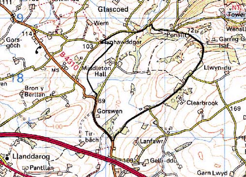
GRID REFERENCE: SN 526179
AREA IN HECTARES: 222.00
Historic Background
A landscape area occupied by the National Botanic Garden of Wales which is coterminous with the former Middleton Park, a landscape which was largely the creation of William Paxton between 1789 and 1824. However, a mansion had existed on the site since at least the 17th century and the area contains features that may relate to prehistoric and Medieval occupation of the site. Most of this history has been taken from Ludlow, 1995. Henry Middleton is said to have built the first mansion in the mid 17th-century and in 1670 the settlement, in whatever form, contained 17 hearths. A warren and fishpond may have been associated with this early phase. The estate passed to the Gwyn family in c.1740. The park lands may have been amassed to form a compact unit by 1789 when Paxton purchased the estate. Under Paxton the mansion was demolished and rebuilt on a different site by the architect Samuel Pepys Cockerell in 1793-5, and a formal parkland had been established by 1815. This was characterised by its extensive use of water features including a chain of lakes and cascades, conceived on a large scale by an unknown landscape designer, possibly William Emes or John Webb, and probably carried out by Paxton's engineer James Grier. A walled garden, stable block, servant's quarters etc. were added by both Cockerell and his successor. Paxton died in 1824 and the estate passed to Edward Adams. The formal parkland features were neglected and much of the land was let out to tenants, giving it a distinctly agricultural feel by the time the Llanarthne tithe map was drawn up in 1849. The water features, however, appear to have been maintained until the present century when the state was acquired by the Hughes family. The hall was gutted by fire in 1931, to be demolished in the 1950s under Carmarthen County council who has acquired the park in the late 1930s, and the parkland continued to deteriorate. Since 1996, however, it has been developed as the National Botanic Garden of Wales
Base map reproduced from the OS map with the permission
of Ordnance Survey on behalf of The Controller of Her Majesty's Stationery
Office, © Crown Copyright 2001.
All rights reserved. Unauthorised reproduction infringes Crown Copyright
and may lead to prosecution or civil proceedings. Licence Number: GD272221
Description and essential historic landscape components
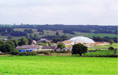
This historic landscape area consists of the former gardens and park land of Middleton Hall; these are currently being restored and transformed into The National Botanic Garden of Wales. The landscape forms a compact oval in plan, divided equally by a south-north flowing stream which joins the westward-flowing Afon Gwynon at the area's northern end, and rises to 120 m at its highest point. Pre-park landscape features include an area of ridge-and-furrow and possible lynchets. The former stream was dammed in 1800-1815 to form a series of ornamental lakes, while the latter was embellished by a series of bridges, waterfalls and cascades. A number of chalybeate springs occur in the park. Middleton Hall has now gone apart from the servant's block, while other buildings and yards survive. Elements of the garden and park remain, though in a dilapidated and/or much neglected condition, including the lakes which had silted-up but are being reinstated, other water features, and drives. The parkland is now mostly improved and unimproved pasture with a little rougher ground, with stands of deciduous trees, and its general open character is the only testimony to its former use. The park boundary is mainly in the form of a low earth bank, with a hedge, but to the north-east is a broken down mortared stone boundary wall. Internal subdivision is mostly by wire fence, with some earth banks and hedges. A massive glasshouse currently under construction, built on the site of the old formal gardens, will be the centrepiece of the new gardens.
With the exception of the pre-parkland features noted above, a ?prehistoric findspot and the earlier mansion site, which may be represented by an earthwork platform, recorded archaeology is mainly in the form of parkland features and buildings. These include the site of the hall which was a broadly neo-Palladian structure, formal gardens, a glasshouse site, an orchard and at least two bath-houses supplied by the chalybeate springs.
The servants' block, from the 1840s, survives but has been transformed virtually beyond recognition into dwellings. The stable block (Grade II listed), double-walled garden, ice-house, and home farm, from 1800-1850, also survive to various degrees and have been restored. There are also the water features which survive in the form of dams, a cascade, a waterfall and bridges, most of them dating from 1800-1815. Lodges survive, though they are now private dwellings