|

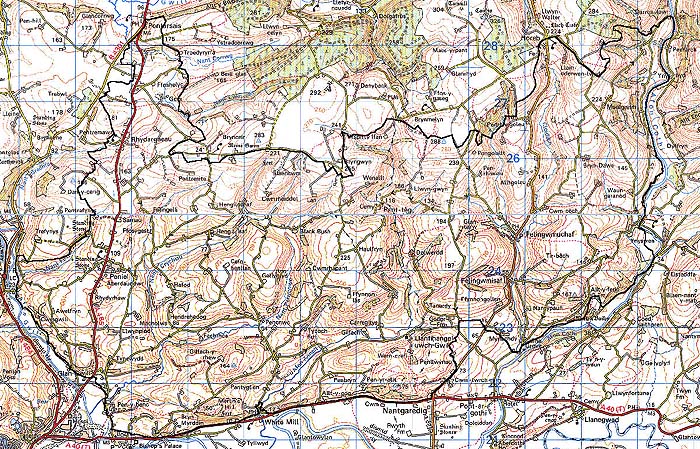
183 ABERGWILI - LLANEGWAD PARISH 
GRID REFERENCE: SN 477247
AREA IN HECTARES: 5017.00
Historic Background
A large area north of the River Tywi. To the south it is dominated by
three bluffs overlooking the river, the eastern of which was occupied
by the large hillfort at Merlin's Hill. This may have been the centre
of a large territory (taking in most of Area 183) and might have approached
oppidum status - it has been suggested that the population was forcibly
cleared to the new Roman town of Moridunum (Williams 1988, 11). However,
there is no demonstrable physical evidence for any Iron Age field systems
in the area. Much of the area's subsequent development was affected by
its association with the main Roman road into West Wales, which forms
the southern limit of the area (see below). During the historic period
most of the area lay within the southern half of the commote, and later
hundred, of Widigada (Rees 1932). This was acquired by King Henry I soon
after the establishment of the castle at Carmarthen (James 1980, 23) and
was held from the crown as the part of the 'Honour' of Carmarthen. The
eastern part of the area, east of the River Cothi, lay within the commote/hundred
of Cetheiniog, which was held of the independent Welsh lordship of Cantref
Mawr until 1284 when the two areas were united with the establishment
of the county of Carmarthen. The relative homogeneity of the present landscape
may represent a historical unity of land-use - much of the area lies above
200 m and may always have been pasture. The church and borough of Abergwili
was a possession of the Bishops of St Davids and the 'Bishop's mill' lies
within this area; there is no evidence, however, for extensive episcopal
agricultural holdings. The south-eastern part of the area belonged within
Maenor Frwnws, an extensive grange belonging to Talley Abbey which extended
into Area 191 (Richards 1974, 119). It may have formed part of the original
grant by Rhys ap Gruffydd during the 1180s-90s and is mentioned in 1324
and 1589 (ibid.). The later Manorial Roll of Talley, of 1633 (Owen 1894,
92-107), gives the location and extent of most of Talley's granges but
Maenor Frwnws was omitted, possibly due to its having been split up. Neither
its tenurial, agricultural or pastoral customs are known, but it is likely
that, in common with most other granges, land was let and farmed by tenants
who established the precursors to the modern farms. Within the curtilage
of the grange lies St Michael, Llanfihangel-uwch-Gwili ('Llanfihangel
Llechweilir') which, however, was always a chapel-of-ease to Abergwili
parish and therefore a possession of St Davids Cathedral (Ludlow 1998).
A possible Knights Hospitaller holding is reflected in the place-name
Yspyty Ifan but this has yet to be established. No gentry estates appear
to have developed from Talley land within this area and the nearby Wern-drefi
house, from the 17th century, appears not to occupy former monastic land
(Jones 1987, 196). There were, however, a number of early gentry houses
within the area including Castell Pigyn, which belonged to the bishop
in 1561 (Jones 1987, 26) but was later privately owned. Gilfach-y-berthog
is said to date from 1327 and was possibly the home of Llewelyn Foethus
who established a chapel near Allt-y-ferin, Cwmgwili was in existence
by c.1460, Hendre Hedog belonged to the Lloyds of Llansteffan in 1575,
Allt-y-gôg, Gelli-fergam, Hengil and Pen-y-banc Ucha had been established
by 1600, and Beili-glas, Esgair-holiw, Pant-yr-ystrad and Pen-y-banc Issa
by at least the 17th century (Jones 1987). None of these was the centre
of a large estate and there are no estate landscapes within this area.
Industry has left its mark in Felingwm where a number of mills, of varying
function, were powered by the fast-flowing Cothi, and a number of former
lead mines were sunk in the area of the bluffs overlooking the Tywi. Twentieth
century development has been minimal, but modern development has occurred
along the A485 road, resulting in linear development and small nucleations
at Peniel and Rhydargaeau.
Base map reproduced from the OS map with the permission
of Ordnance Survey on behalf of The Controller of Her Majesty's Stationery
Office, © Crown Copyright 2001.
All rights reserved. Unauthorised reproduction infringes Crown Copyright
and may lead to prosecution or civil proceedings. Licence Number: GD272221
Description and essential historic landscape components
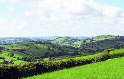
Despite its very large size, this historic landscape area is coherent, comprising as it does rolling hills of enclosed pasture and dispersed farms. From the junction of the valley floor of the River Tywi to the south at 15 m above sea level, this area rises steeply to over 100 m, and continues to rise in a series of rounded hills interspersed with deeply incised valleys to over 240 m. Valley sides are steep and often cloaked with ancient deciduous woodland. However, most of this area is enclosed under rich pasture, with the vast majority improved grazing and very little rough grazing and unimproved land. Fields are small- to medium-sized and irregular. Boundaries are universally of earth banks topped with hedges. Hedges are generally well maintained at lower levels, though gaps are opening in some examples. At higher altitudes there is a tendency for them to be neglected and here there is some dereliction. Wire fences supplement most boundaries. Distinctive hedgerow trees are present, but not common. The old established settlement pattern is predominantly one of dispersed farms, with clustering at White Mill and Felingwm-uchaf. Modern ribbon development has taken place along main roads. Within this area are three important routeways. The most important is the east-west corridor along the southern limits in the Tywi valley along the interface between the alluvium and the solid geology of the north side of the river. Here the A40(T) - which in 1999 was upgraded as part of the Carmarthen eastern bypass - is based on a turnpike route, which in turn follows the course of the Carmarthen to Llandovery Roman road. Running close to the western boundary of the area is the north-to-south A485 Carmarthen to Llandeilo road which also follows the general course of a Roman road. The B4310 runs north-to-south across the eastern section of the area.
Recorded archaeology from such a large landscape area takes in a range of sites from all periods. However, notable sites include the large hillfort at Merlin's Hill and the Roman road. Prehistoric and Medieval archaeology relates primarily to agricultural land-use but Post-Medieval features include chapels, mills and lead mine shafts.
St Michael, Llanfihangel-uwch-Gwili, a landmark church with Medieval origins and an unusual early 17th-century tower is Grade B listed. Few of the gentry houses retain early fabric but Cwmgwili, mentioned in c.1460, now mainly 18th century but with 16th- or 17th-century features, is Grade II listed. Gilfach-y-berthog was extensively remodelled in 1692 and is Grade II* listed, with Grade II listed stables and barn. The 18th- and 19th-century White Mill is Grade II listed. Gelli-fergam, mentioned in the late 16th-century is now a substantial double-piled house with a walled garden. Esgair-holiw retains no early features but is associated with a former water-mill. Traditionally farms are stone-built, two-storey, three-bay and generally of 19th century date and in the vernacular tradition, though there are examples in the more 'polite' Georgian style. Farms have one or two ranges of stone-built, 19th century outbuildings, very occasionally arranged semi-formally around a yard, together with modern agricultural buildings. Modern dwellings tend to be in small estates at Peniel and Rhydargaeau, in ribbon development alongside the A485, or as dispersed houses which are mostly situated alongside the main roads. This modern development is in a variety of styles and materials.
The boundary of this area to the south against Ystrad Tywi is very well defined at the foot of the valley floor. To the north there is similar good definition where high common land enclosed by Act of Parliament in the 19th century provides a distinctive landscape signature. The area to the southeast is very similar in character to this area, but generally of lower altitude - there is no clear-cut boundary between the two. Areas to the east and west have yet to be defined, but they contain many similar components to Abergwili-Llanegwad Parish historic character area.